Trail On foot Rybnica - Tarnobrzeska Droga św. Jakuba - Photo

Tous les sentiers balisés d’Europe GUIDE+

© OpenStreetMap contributors
Length
Length
21 km
Max alt
Max alt
210 m
Uphill gradient
Uphill gradient
161 m
Km-Effort
Km-Effort  
23 km
Min alt
Min alt
134 m
Downhill gradient
Downhill gradient
170 m
Boucle
Boucle
No
Signpost
Signpost
Creation date :
2022-02-16 16:28:39.849
Updated on :
2022-03-08 12:14:20.669

(0 Reviews)

On foot
On foot
5h10
Difficulty : Medium

Scan this QR Code to open this trail in the SityTrail application

FREE GPS app for hiking

Logo SityTrail SityTrail

IGN / Geographical institutes

Download SityTrail from the App Store Download SityTrail from Google Play

Logo SityTrail SityTrail World

The world is yours!

Download SityTrail from the App Store Download SityTrail from Google Play Download SityTrail on Huawei AppGallery

About

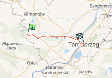
Trail On foot of 21 km to be discovered at Świętokrzyskie Voivodeship, Sandomierz County, Rybnica. This trail is proposed by SityTrail - itinéraires balisés pédestres.

Description

Na pytanie zadane dawnemu arcybiskupowi Paryża, kardynałowi Jean-Marie Lustigerowi, ile jest dróg do Pana Boga, odpowiedział: tyle ilu jest ludzi na świecie. Na pytanie, ile jest dróg do grobu Jakuba w Santiago de Compostela również trzeba odpowiedzieć, że zapewne tyle, ilu jest ludzi na świecie. Nie ma jednej, a często można wybrać alternatywne trasy. Otwarta…

Website: https://sandomierz.wordpress.com/2010/09/14/tarnobrzeska-droga-sw-jakuba/

Elevation profile

Photos

Positioning

Country:
Poland
Region :
Świętokrzyskie Voivodeship
Department/Province :
Sandomierz County
Municipality :
Rybnica
Location:
Unknown
Start:(UTM)
529982 ; 5605538 (34U) N.

Trails nearby

Trail On foot Pielaszów - Gołoszyce - Dwikozy - Photo
On foot
GUIDE+

On foot

Easy
Pielaszów, Świętokrzyskie Voivodeship, Sandomierz County, Poland
16.5 km | 18.3 km-effort
4h 8min
No


Close
My subscriptions