Trail On foot Mariazell - Mariazeller Land Rundwanderweg - Photo

Mariazeller Land Rundwanderweg

Tous les sentiers balisés d’Europe PRO

© OpenStreetMap contributors
Length
Length
13.4 km
Max alt
Max alt
883 m
Uphill gradient
Uphill gradient
258 m
Km-Effort
Km-Effort  
16.9 km
Min alt
Min alt
774 m
Downhill gradient
Downhill gradient
257 m
Boucle
Boucle
Yes
Signpost
Signpost
Creation date :
2022-02-16 16:26:43.286
Updated on :
2022-03-03 08:40:48.145

(0 Reviews)

On foot
On foot
3h49
Difficulty : Easy

Scan this QR Code to open this trail in the SityTrail application

FREE GPS app for hiking

Logo SityTrail SityTrail

IGN / Geographical institutes

Download SityTrail from the App Store Download SityTrail from Google Play

Logo SityTrail SityTrail World

The world is yours!

Download SityTrail from the App Store Download SityTrail from Google Play Download SityTrail on Huawei AppGallery

About

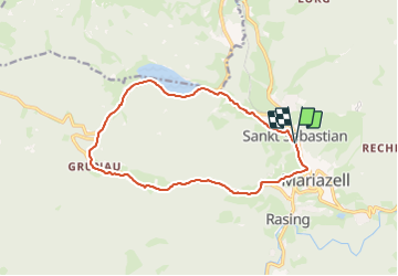
Trail On foot of 13.4 km to be discovered at Styria, Bezirk Bruck-Mürzzuschlag, Mariazell. This trail is proposed by SityTrail - itinéraires balisés pédestres.

Description

Symbol: zweiteilig waagrecht, weiß oben, grün unten, Aufschrift: Mariazeller Land Rundwanderweg


Website: https://www.mariazell.at/mein-urlaub/wandern/wanderwege-spaziergange/rundwanderweg/

Photos

Positioning

Country:
Austria
Region :
Styria
Department/Province :
Bezirk Bruck-Mürzzuschlag
Municipality :
Mariazell
Location:
Unknown
Start:(UTM)
523320 ; 5291837 (33T) N.

Trails nearby

Trail On foot Gemeinde Mitterbach am Erlaufsee - Erlaufsee - Brunnsteinalm - Photo
On foot
PRO

On foot

Easy
Gemeinde Mitterbach am Erlaufsee, Lower Austria, Bezirk Lilienfeld, Austria
5.9 km | 11.5 km-effort
2h 36min
No
Trail Cycle Mariazell - f-oostenrijk-traisental-radweg-mariazell-lilienfeld - Photo
Cycle
gpstracks

Cycle

Very easy
Mariazell, Styria, Bezirk Bruck-Mürzzuschlag, Austria
58 km | 70 km-effort
Unknown
No


Close
My subscriptions