![](/images/other/stat-length.png)
![Trail On foot Dienten am Hochkönig - Schwarzenbachtal-Hirtenkapelle - Photo](https://media.geolcdn.com/t/1900/400/0b915dfc-f400-4cff-ae8c-f65c2305edd4.jpeg&format=pjpeg&maxdim=2)
Schwarzenbachtal-Hirtenkapelle
SityTrail - itinéraires balisés pédestres
Tous les sentiers balisés d’Europe GUIDE+
![Length](/images/other/stat-length.png)
Length
6.1 km
![Max alt](https://static1.geolcdn.com/siteimages/upload/files/1508320355ic_sort_altitude_max_24dp.png)
Max alt
1378 m
![Uphill gradient](https://static1.geolcdn.com/siteimages/upload/files/1508320355ic_sort_den_pos_24dp.png)
Uphill gradient
454 m
![Km-Effort](/images/other/stat-length.png)
Km-Effort
10.9 km
![Min alt](https://static1.geolcdn.com/siteimages/upload/files/1508320355ic_sort_altitude_min_24dp.png)
Min alt
1001 m
![Downhill gradient](https://static1.geolcdn.com/siteimages/upload/files/1508320355ic_sort_den_neg_24dp.png)
Downhill gradient
92 m
![Boucle](https://static1.geolcdn.com/siteimages/upload/files/16400158638029165_repeat_loop_refresh_sync_direction_icon.png)
Boucle
No
Signpost
Creation date :
2022-02-16 16:24:11.87
Updated on :
2022-03-03 07:30:09.494
![On foot](https://static1.geolcdn.com/sitytour/trail-icons/100.png)
2h28
Difficulty : Easy
![Scan this QR Code to open this trail in the SityTrail application](https://capi.geolives.com/qq0zvz2zws4bq2lad0pu/sitytour/trails/3126953/qr.png?size=200)
FREE GPS app for hiking
About
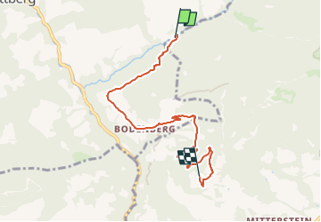
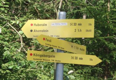
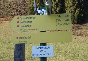
Trail On foot of 6.1 km to be discovered at Salzburg, Bezirk Zell am See, Dienten am Hochkönig. This trail is proposed by SityTrail - itinéraires balisés pédestres.
Description
Trail created by TVB Hochkönig.
Symbol: rot-weiss-rot
Positioning
Country:
Austria
Region :
Salzburg
Department/Province :
Bezirk Zell am See
Municipality :
Dienten am Hochkönig
Location:
Unknown
Start:(Dec)
Start:(UTM)
351649 ; 5245182 (33T) N.
Comments
Trails nearby
![Trail On foot Mühlbach am Hochkönig - Mühlbach-Pronebenalm-Karbachalm - Photo](https://media.geolcdn.com/t/375/260/3d7a7ddf-10fa-4d47-a362-cb5930ed8e60.jpeg&format=jpg&maxdim=2)
![On foot On foot](https://static1.geolcdn.com/sitytour/trail-icons/100.png)
Mühlbach-Pronebenalm-Karbachalm
On foot
Easy
Mühlbach am Hochkönig,
Salzburg,
Bezirk St. Johann im Pongau,
Austria
![](/images/other/stat-length.png)
12 km | 17.9 km-effort
4h 3min
![](https://static1.geolcdn.com/siteimages/upload/files/16400158638029165_repeat_loop_refresh_sync_direction_icon.png)
No
![Trail On foot Dienten am Hochkönig - Sonnberg-Königsbergalm - Photo](https://media.geolcdn.com/t/375/260/0dbab340-c11e-4f8b-80d8-87d045357c87.jpeg&format=jpg&maxdim=2)
![On foot On foot](https://static1.geolcdn.com/sitytour/trail-icons/100.png)
Sonnberg-Königsbergalm
On foot
Easy
Dienten am Hochkönig,
Salzburg,
Bezirk Zell am See,
Austria
![](/images/other/stat-length.png)
3.5 km | 6.9 km-effort
1h 33min
![](https://static1.geolcdn.com/siteimages/upload/files/16400158638029165_repeat_loop_refresh_sync_direction_icon.png)
No
![Trail On foot Dienten am Hochkönig - Fischerstüberl-Schwarzenbachtal - Photo](https://media.geolcdn.com/t/375/260/35d508a8-659d-4f5c-925e-8aaade171a04.jpeg&format=jpg&maxdim=2)
![On foot On foot](https://static1.geolcdn.com/sitytour/trail-icons/100.png)
Fischerstüberl-Schwarzenbachtal
On foot
Easy
Dienten am Hochkönig,
Salzburg,
Bezirk Zell am See,
Austria
![](/images/other/stat-length.png)
4.4 km | 6.6 km-effort
1h 30min
![](https://static1.geolcdn.com/siteimages/upload/files/16400158638029165_repeat_loop_refresh_sync_direction_icon.png)
No
![Trail On foot Dienten am Hochkönig - Fischerstüberl-Ahornstein - Photo](https://media.geolcdn.com/t/375/260/c85f6051-7326-4610-abf6-026adb3ddb59.jpeg&format=jpg&maxdim=2)
![On foot On foot](https://static1.geolcdn.com/sitytour/trail-icons/100.png)
Fischerstüberl-Ahornstein
On foot
Easy
Dienten am Hochkönig,
Salzburg,
Bezirk Zell am See,
Austria
![](/images/other/stat-length.png)
6.8 km | 15.5 km-effort
3h 31min
![](https://static1.geolcdn.com/siteimages/upload/files/16400158638029165_repeat_loop_refresh_sync_direction_icon.png)
No
![Trail On foot Dienten am Hochkönig - Feroli-Moaralm - Photo](https://media.geolcdn.com/t/375/260/4cc2a360-db3a-4551-abc6-5af8d6557030.jpeg&format=jpg&maxdim=2)
![On foot On foot](https://static1.geolcdn.com/sitytour/trail-icons/100.png)
Feroli-Moaralm
On foot
Easy
Dienten am Hochkönig,
Salzburg,
Bezirk Zell am See,
Austria
![](/images/other/stat-length.png)
9.1 km | 17 km-effort
3h 52min
![](https://static1.geolcdn.com/siteimages/upload/files/16400158638029165_repeat_loop_refresh_sync_direction_icon.png)
No
![Trail On foot Goldegg - Meiselsteinalm-Gamskögerl - Photo](https://media.geolcdn.com/t/375/260/0949b28c-cc23-4553-826d-f0e7d33b53bb.jpeg&format=jpg&maxdim=2)
![On foot On foot](https://static1.geolcdn.com/sitytour/trail-icons/100.png)
Meiselsteinalm-Gamskögerl
On foot
Easy
Goldegg,
Salzburg,
Bezirk St. Johann im Pongau,
Austria
![](/images/other/stat-length.png)
4.2 km | 9.1 km-effort
2h 3min
![](https://static1.geolcdn.com/siteimages/upload/files/16400158638029165_repeat_loop_refresh_sync_direction_icon.png)
No
![Trail On foot Goldegg - Meiselsteinalm - Photo](https://media.geolcdn.com/t/375/260/8ffc85f0-263e-48f3-9608-80690effc7ee.jpeg&format=jpg&maxdim=2)
![On foot On foot](https://static1.geolcdn.com/sitytour/trail-icons/100.png)
Meiselsteinalm
On foot
Easy
Goldegg,
Salzburg,
Bezirk St. Johann im Pongau,
Austria
![](/images/other/stat-length.png)
8.1 km | 13.9 km-effort
3h 10min
![](https://static1.geolcdn.com/siteimages/upload/files/16400158638029165_repeat_loop_refresh_sync_direction_icon.png)
No
![Trail On foot Goldegg - Goldegg-St. Veit über Urpass - Photo](https://media.geolcdn.com/t/375/260/8f51bacc-9048-4266-9bae-0a4a37b4fdcc.jpeg&format=jpg&maxdim=2)
![On foot On foot](https://static1.geolcdn.com/sitytour/trail-icons/100.png)
Goldegg-St. Veit über Urpass
On foot
Easy
Goldegg,
Salzburg,
Bezirk St. Johann im Pongau,
Austria
![](/images/other/stat-length.png)
5 km | 7.6 km-effort
1h 43min
![](https://static1.geolcdn.com/siteimages/upload/files/16400158638029165_repeat_loop_refresh_sync_direction_icon.png)
No
![Trail On foot Goldegg - Goldegg-Schwarzach über Schernberg - Photo](https://media.geolcdn.com/t/375/260/9d0ee89a-2181-4ffa-b97e-dd8b3b82671a.jpeg&format=jpg&maxdim=2)
![On foot On foot](https://static1.geolcdn.com/sitytour/trail-icons/100.png)
Goldegg-Schwarzach über Schernberg
On foot
Easy
Goldegg,
Salzburg,
Bezirk St. Johann im Pongau,
Austria
![](/images/other/stat-length.png)
4.5 km | 6.6 km-effort
1h 30min
![](https://static1.geolcdn.com/siteimages/upload/files/16400158638029165_repeat_loop_refresh_sync_direction_icon.png)
No