Trail On foot Szklary Górne - Szklary Górne - Lubin - Photo

Tous les sentiers balisés d’Europe PRO

© OpenStreetMap contributors
Length
Length
11.2 km
Max alt
Max alt
189 m
Uphill gradient
Uphill gradient
75 m
Km-Effort
Km-Effort  
12.3 km
Min alt
Min alt
129 m
Downhill gradient
Downhill gradient
93 m
Boucle
Boucle
No
Signpost
Signpost
Creation date :
2022-02-16 16:22:31.703
Updated on :
2022-03-08 11:29:26.58

(0 Reviews)

On foot
On foot
2h47
Difficulty : Easy

Scan this QR Code to open this trail in the SityTrail application

FREE GPS app for hiking

Logo SityTrail SityTrail

IGN / Geographical institutes

Download SityTrail from the App Store Download SityTrail from Google Play

Logo SityTrail SityTrail World

The world is yours!

Download SityTrail from the App Store Download SityTrail from Google Play Download SityTrail on Huawei AppGallery

About

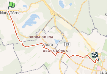
Trail On foot of 11.2 km to be discovered at Lower Silesian Voivodeship, Lubin County, Szklary Górne. This trail is proposed by SityTrail - itinéraires balisés pédestres.

Photos

Positioning

Country:
Poland
Region :
Lower Silesian Voivodeship
Department/Province :
Lubin County
Municipality :
Szklary Górne
Location:
Unknown
Start:(UTM)
575941 ; 5699525 (33U) N.

Trails nearby

Trail On foot  - Szlak leśny - Photo
On foot
PRO

On foot

Easy
, Lower Silesian Voivodeship, Lubin County, Poland
17.4 km | 19.9 km-effort
4h 30min
No
Trail On foot Krzeczyn Mały - Dookoła Lubina - Photo
On foot
PRO

On foot

Very difficult
Krzeczyn Mały, Lower Silesian Voivodeship, Lubin County, Poland
86 km | 99 km-effort
22h 23min
Yes
Trail On foot  - Szlak zabytków - Photo
On foot
PRO

On foot

Easy
, Lower Silesian Voivodeship, Lubin County, Poland
16.8 km | 18.4 km-effort
4h 11min
No
Trail On foot Michałów - Ścieżka dydaktyczna
On foot
PRO

On foot

Easy
Michałów, Lower Silesian Voivodeship, Polkowice County, Poland
4 km | 4.3 km-effort
58min
Yes


Close
My subscriptions