![](/images/other/stat-length.png)
![Trail On foot Gemeinde Kirchdorf in Tirol - Wanderweg 20 - Feldberg/Scheibenbichlalm/Kaisertal - Photo](https://media.geolcdn.com/t/1900/400/3da103bf-952f-47cd-bb86-575e2cc8ca8b.jpeg&format=pjpeg&maxdim=2)
Wanderweg 20 - Feldberg/Scheibenbichlalm/Kaisertal
SityTrail - itinéraires balisés pédestres
Tous les sentiers balisés d’Europe GUIDE+
![Length](/images/other/stat-length.png)
Length
7.4 km
![Max alt](https://static1.geolcdn.com/siteimages/upload/files/1508320355ic_sort_altitude_max_24dp.png)
Max alt
1791 m
![Uphill gradient](https://static1.geolcdn.com/siteimages/upload/files/1508320355ic_sort_den_pos_24dp.png)
Uphill gradient
1045 m
![Km-Effort](/images/other/stat-length.png)
Km-Effort
18 km
![Min alt](https://static1.geolcdn.com/siteimages/upload/files/1508320355ic_sort_altitude_min_24dp.png)
Min alt
767 m
![Downhill gradient](https://static1.geolcdn.com/siteimages/upload/files/1508320355ic_sort_den_neg_24dp.png)
Downhill gradient
35 m
![Boucle](https://static1.geolcdn.com/siteimages/upload/files/16400158638029165_repeat_loop_refresh_sync_direction_icon.png)
Boucle
No
Signpost
Creation date :
2022-02-16 16:21:39.282
Updated on :
2022-03-03 06:14:52.754
![On foot](https://static1.geolcdn.com/sitytour/trail-icons/100.png)
4h05
Difficulty : Easy
![Scan this QR Code to open this trail in the SityTrail application](https://capi.geolives.com/qq0zvz2zws4bq2lad0pu/sitytour/trails/3126734/qr.png?size=200)
FREE GPS app for hiking
About
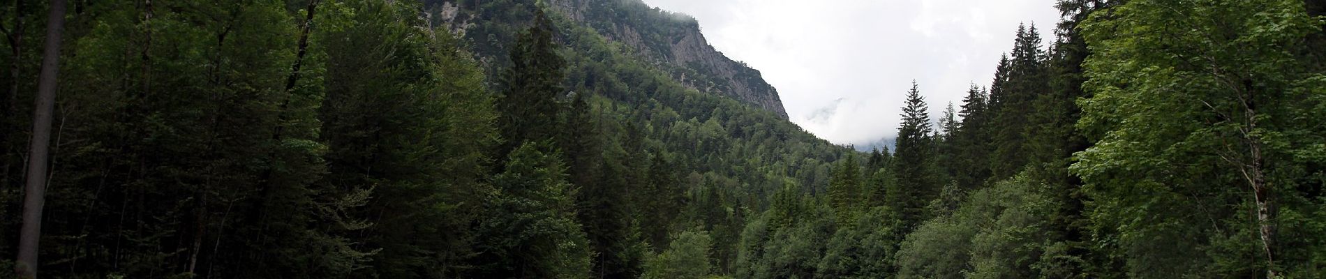
Trail On foot of 7.4 km to be discovered at Tyrol, Bezirk Kitzbühel, Gemeinde Kirchdorf in Tirol. This trail is proposed by SityTrail - itinéraires balisés pédestres.
Description
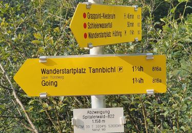
Trail created by TVB Kirchdorf.
Symbol: Rot/Weiß gestreift, Wegenummer 20 bei unterer Scheibenbichlalm
Positioning
Country:
Austria
Region :
Tyrol
Department/Province :
Bezirk Kitzbühel
Municipality :
Gemeinde Kirchdorf in Tirol
Location:
Unknown
Start:(Dec)
Start:(UTM)
302334 ; 5272949 (33T) N.
Comments
Trails nearby
![Trail On foot Gemeinde Kirchdorf in Tirol - Wanderweg 9 - Niederkaiser - Photo](https://media.geolcdn.com/t/375/260/f87f391c-0aba-406d-938f-5f3b1c015437.jpeg&format=jpg&maxdim=2)
![On foot On foot](https://static1.geolcdn.com/sitytour/trail-icons/100.png)
Wanderweg 9 - Niederkaiser
On foot
Easy
Gemeinde Kirchdorf in Tirol,
Tyrol,
Bezirk Kitzbühel,
Austria
![](/images/other/stat-length.png)
4.3 km | 8.1 km-effort
1h 51min
![](https://static1.geolcdn.com/siteimages/upload/files/16400158638029165_repeat_loop_refresh_sync_direction_icon.png)
No
![Trail On foot Gemeinde Ellmau - Wanderweg 14 - Wilder Kaiser - Photo](https://media.geolcdn.com/t/375/260/bab70f22-d8e2-49f4-93b1-d49ec6cea7db.jpeg&format=jpg&maxdim=2)
![On foot On foot](https://static1.geolcdn.com/sitytour/trail-icons/100.png)
Wanderweg 14 - Wilder Kaiser
On foot
Medium
Gemeinde Ellmau,
Tyrol,
Bezirk Kufstein,
Austria
![](/images/other/stat-length.png)
14.1 km | 22 km-effort
4h 59min
![](https://static1.geolcdn.com/siteimages/upload/files/16400158638029165_repeat_loop_refresh_sync_direction_icon.png)
Yes
![Trail On foot Gemeinde Going am Wilden Kaiser - Wanderweg 33 - Niederkaiser - Photo](https://media.geolcdn.com/t/375/260/f93090ce-0e16-439e-8b92-0ccc37951e89.jpeg&format=jpg&maxdim=2)
![On foot On foot](https://static1.geolcdn.com/sitytour/trail-icons/100.png)
Wanderweg 33 - Niederkaiser
On foot
Easy
Gemeinde Going am Wilden Kaiser,
Tyrol,
Bezirk Kitzbühel,
Austria
![](/images/other/stat-length.png)
3.2 km | 5 km-effort
1h 7min
![](https://static1.geolcdn.com/siteimages/upload/files/16400158638029165_repeat_loop_refresh_sync_direction_icon.png)
No
![Trail On foot Gemeinde Walchsee - Walchsee - Gwirchtalm - Hochalm - Feldalmsattel - Photo](https://media.geolcdn.com/t/375/260/015cb715-7db0-4604-9051-5822a1bdce81.jpeg&format=jpg&maxdim=2)
![On foot On foot](https://static1.geolcdn.com/sitytour/trail-icons/100.png)
Walchsee - Gwirchtalm - Hochalm - Feldalmsattel
On foot
Easy
Gemeinde Walchsee,
Tyrol,
Bezirk Kufstein,
Austria
![](/images/other/stat-length.png)
3.9 km | 8 km-effort
1h 48min
![](https://static1.geolcdn.com/siteimages/upload/files/16400158638029165_repeat_loop_refresh_sync_direction_icon.png)
No
![Trail On foot Gemeinde Going am Wilden Kaiser - Gildensteig - Photo](https://media.geolcdn.com/t/375/260/ext.jpg?maxdim=2&url=https%3A%2F%2Fstatic1.geolcdn.com%2Fsiteimages%2Fupload%2Ffiles%2F1545311037marcheuse_200dpi.jpg)
![On foot On foot](https://static1.geolcdn.com/sitytour/trail-icons/100.png)
Gildensteig
On foot
Easy
Gemeinde Going am Wilden Kaiser,
Tyrol,
Bezirk Kitzbühel,
Austria
![](/images/other/stat-length.png)
4 km | 14.3 km-effort
3h 14min
![](https://static1.geolcdn.com/siteimages/upload/files/16400158638029165_repeat_loop_refresh_sync_direction_icon.png)
No
![Trail Walking Gemeinde Kirchdorf in Tirol - grisenau gasteig - Photo](https://media.geolcdn.com/t/375/260/fc227cc1-116f-4a5d-a57b-7b21c8ef27eb.jpg&format=jpg&maxdim=2)
![Walking Walking](https://static1.geolcdn.com/sitytour/trail-icons/101.png)
grisenau gasteig
Walking
Very easy
Gemeinde Kirchdorf in Tirol,
Tyrol,
Bezirk Kitzbühel,
Austria
![](/images/other/stat-length.png)
13.5 km | 21 km-effort
4h 42min
![](https://static1.geolcdn.com/siteimages/upload/files/16400158638029165_repeat_loop_refresh_sync_direction_icon.png)
Yes