![](/images/other/stat-length.png)
![Trail On foot Gemeinde Rinn - Hasental-Trail - Photo](https://media.geolcdn.com/t/1900/400/ext.pjpeg?maxdim=2&url=https%3A%2F%2Fmedia.geolcdn.com%2Ff%2F2ef403ba-f96e-4e77-a8e7-6adba28f9e16.jpeg)
Hasental-Trail
SityTrail - itinéraires balisés pédestres
Tous les sentiers balisés d’Europe PRO
![Length](/images/other/stat-length.png)
Length
8.1 km
![Max alt](https://static1.geolcdn.com/siteimages/upload/files/1508320355ic_sort_altitude_max_24dp.png)
Max alt
910 m
![Uphill gradient](https://static1.geolcdn.com/siteimages/upload/files/1508320355ic_sort_den_pos_24dp.png)
Uphill gradient
229 m
![Km-Effort](/images/other/stat-length.png)
Km-Effort
11.2 km
![Min alt](https://static1.geolcdn.com/siteimages/upload/files/1508320355ic_sort_altitude_min_24dp.png)
Min alt
754 m
![Downhill gradient](https://static1.geolcdn.com/siteimages/upload/files/1508320355ic_sort_den_neg_24dp.png)
Downhill gradient
230 m
![Boucle](https://static1.geolcdn.com/siteimages/upload/files/16400158638029165_repeat_loop_refresh_sync_direction_icon.png)
Boucle
Yes
Signpost
Creation date :
2022-02-16 16:18:13.096
Updated on :
2022-03-03 04:59:08.082
![On foot](https://static1.geolcdn.com/sitytour/trail-icons/100.png)
2h32
Difficulty : Easy
![Scan this QR Code to open this trail in the SityTrail application](https://capi.geolives.com/qq0zvz2zws4bq2lad0pu/sitytour/trails/3126545/qr.png?size=200)
FREE GPS app for hiking
About
Trail On foot of 8.1 km to be discovered at Tyrol, Bezirk Innsbruck-Land, Gemeinde Rinn. This trail is proposed by SityTrail - itinéraires balisés pédestres.
Description
Website: https://www.innsbruck.info/wandern/wandern/wanderungen/touren/hasental-trail-38-1.html
Positioning
Country:
Austria
Region :
Tyrol
Department/Province :
Bezirk Innsbruck-Land
Municipality :
Gemeinde Rinn
Location:
Unknown
Start:(Dec)
Start:(UTM)
689079 ; 5236780 (32T) N.
Comments
Trails nearby
![Trail On foot Gemeinde Ampass - Rundwanderweg Ebenwald - Photo](https://media.geolcdn.com/t/375/260/ext.jpg?maxdim=2&url=https%3A%2F%2Fmedia.geolcdn.com%2Ff%2F663f064d-6b92-441b-ac0a-74247308b578.jpeg)
![On foot On foot](https://static1.geolcdn.com/sitytour/trail-icons/100.png)
Rundwanderweg Ebenwald
On foot
Easy
Gemeinde Ampass,
Tyrol,
Bezirk Innsbruck-Land,
Austria
![](/images/other/stat-length.png)
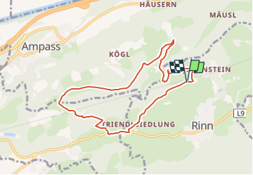
8.4 km | 13.1 km-effort
2h 58min
![](https://static1.geolcdn.com/siteimages/upload/files/16400158638029165_repeat_loop_refresh_sync_direction_icon.png)
Yes
![Trail On foot Gemeinde Ampass - Rundwanderweg Herztal - Photo](https://media.geolcdn.com/t/375/260/ext.jpg?maxdim=2&url=https%3A%2F%2Fmedia.geolcdn.com%2Ff%2F441c147d-ba1e-4054-afb1-3b436f27998e.jpeg)
![On foot On foot](https://static1.geolcdn.com/sitytour/trail-icons/100.png)
Rundwanderweg Herztal
On foot
Easy
Gemeinde Ampass,
Tyrol,
Bezirk Innsbruck-Land,
Austria
![](/images/other/stat-length.png)
4.1 km | 6.1 km-effort
1h 23min
![](https://static1.geolcdn.com/siteimages/upload/files/16400158638029165_repeat_loop_refresh_sync_direction_icon.png)
Yes
![Trail On foot Gemeinde Rinn - Rundwanderweg Poltental - Photo](https://media.geolcdn.com/t/375/260/ext.jpg?maxdim=2&url=https%3A%2F%2Fmedia.geolcdn.com%2Ff%2F51a02d20-5582-44b5-b69e-1765736a126e.jpeg)
![On foot On foot](https://static1.geolcdn.com/sitytour/trail-icons/100.png)
Rundwanderweg Poltental
On foot
Easy
Gemeinde Rinn,
Tyrol,
Bezirk Innsbruck-Land,
Austria
![](/images/other/stat-length.png)
6 km | 8.7 km-effort
1h 58min
![](https://static1.geolcdn.com/siteimages/upload/files/16400158638029165_repeat_loop_refresh_sync_direction_icon.png)
Yes
![Trail On foot Gemeinde Rinn - Rundwanderweg Hasental - Photo](https://media.geolcdn.com/t/375/260/ext.jpg?maxdim=2&url=https%3A%2F%2Fmedia.geolcdn.com%2Ff%2F27dfb8ee-3ee4-40ad-a10e-f6085849f734.jpeg)
![On foot On foot](https://static1.geolcdn.com/sitytour/trail-icons/100.png)
Rundwanderweg Hasental
On foot
Easy
Gemeinde Rinn,
Tyrol,
Bezirk Innsbruck-Land,
Austria
![](/images/other/stat-length.png)
3.6 km | 5.9 km-effort
1h 19min
![](https://static1.geolcdn.com/siteimages/upload/files/16400158638029165_repeat_loop_refresh_sync_direction_icon.png)
Yes
![Trail On foot Gemeinde Rinn - Grafen-Schleife - Photo](https://media.geolcdn.com/t/375/260/ext.jpg?maxdim=2&url=https%3A%2F%2Fmedia.geolcdn.com%2Ff%2F51a02d20-5582-44b5-b69e-1765736a126e.jpeg)
![On foot On foot](https://static1.geolcdn.com/sitytour/trail-icons/100.png)
Grafen-Schleife
On foot
Easy
Gemeinde Rinn,
Tyrol,
Bezirk Innsbruck-Land,
Austria
![](/images/other/stat-length.png)
5 km | 6.6 km-effort
1h 30min
![](https://static1.geolcdn.com/siteimages/upload/files/16400158638029165_repeat_loop_refresh_sync_direction_icon.png)
Yes
![Trail On foot Gemeinde Rinn - Marterl-Runde - Photo](https://media.geolcdn.com/t/375/260/ext.jpg?maxdim=2&url=https%3A%2F%2Fmedia.geolcdn.com%2Ff%2Fc199f871-f695-4628-b90d-b44001345d7d.jpeg)
![On foot On foot](https://static1.geolcdn.com/sitytour/trail-icons/100.png)
Marterl-Runde
On foot
Easy
Gemeinde Rinn,
Tyrol,
Bezirk Innsbruck-Land,
Austria
![](/images/other/stat-length.png)
3.7 km | 4.9 km-effort
1h 6min
![](https://static1.geolcdn.com/siteimages/upload/files/16400158638029165_repeat_loop_refresh_sync_direction_icon.png)
Yes
![Trail Touring skiing Gemeinde Tulfes - glungezerhutte - Photo](https://media.geolcdn.com/t/375/260/ext.jpg?maxdim=2&url=https%3A%2F%2Fmedia.geolcdn.com%2Ff%2Fb9cdfa21-4e7e-4df6-b782-58d5fc44612e.jpg)
![Touring skiing Touring skiing](https://static1.geolcdn.com/sitytour/trail-icons/503.png)
glungezerhutte
Touring skiing
Medium
Gemeinde Tulfes,
Tyrol,
Bezirk Innsbruck-Land,
Austria
![](/images/other/stat-length.png)
3 km | 8.3 km-effort
1h 16min
![](https://static1.geolcdn.com/siteimages/upload/files/16400158638029165_repeat_loop_refresh_sync_direction_icon.png)
No