![](/images/other/stat-length.png)
![Trail On foot Deutschfeistritz - Wanderweg 15 - Photo](https://media.geolcdn.com/t/1900/400/e42d2043-4db5-4d92-af7e-45864951716a.jpeg&format=pjpeg&maxdim=2)
Wanderweg 15
SityTrail - itinéraires balisés pédestres
Tous les sentiers balisés d’Europe GUIDE+
![Length](/images/other/stat-length.png)
![Max alt](https://static1.geolcdn.com/siteimages/upload/files/1508320355ic_sort_altitude_max_24dp.png)
![Uphill gradient](https://static1.geolcdn.com/siteimages/upload/files/1508320355ic_sort_den_pos_24dp.png)
![Km-Effort](/images/other/stat-length.png)
![Min alt](https://static1.geolcdn.com/siteimages/upload/files/1508320355ic_sort_altitude_min_24dp.png)
![Downhill gradient](https://static1.geolcdn.com/siteimages/upload/files/1508320355ic_sort_den_neg_24dp.png)
![Boucle](https://static1.geolcdn.com/siteimages/upload/files/16400158638029165_repeat_loop_refresh_sync_direction_icon.png)
![On foot](https://static1.geolcdn.com/sitytour/trail-icons/100.png)
3h49
Difficulty : Easy
![Scan this QR Code to open this trail in the SityTrail application](https://capi.geolives.com/qq0zvz2zws4bq2lad0pu/sitytour/trails/3126357/qr.png?size=200)
FREE GPS app for hiking
About
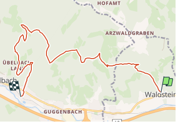
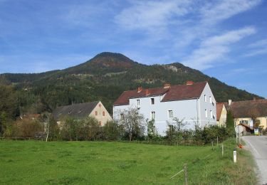
Trail On foot of 9.4 km to be discovered at Styria, Bezirk Graz-Umgebung, Deutschfeistritz. This trail is proposed by SityTrail - itinéraires balisés pédestres.
Description
streckenweise sehr schlecht markiert (manchmal nur rote punkte, manchmal nur schwarze '15'), Bereich Schankkogel: Markierung entspricht nicht Karteneinträgen -> hier Varianten enthalten
Symbol: rot-weiss-rot 15
Positioning
Comments
Trails nearby
![Trail On foot Deutschfeistritz - Wanderweg 17 - Photo](https://media.geolcdn.com/t/375/260/4b3161d2-9c2b-4b77-ab86-864db825788d.jpeg&format=jpg&maxdim=2)
![On foot On foot](https://static1.geolcdn.com/sitytour/trail-icons/100.png)
On foot
![](/images/other/stat-length.png)
![](https://static1.geolcdn.com/siteimages/upload/files/16400158638029165_repeat_loop_refresh_sync_direction_icon.png)
![Trail On foot Deutschfeistritz - Wanderweg 17 - Photo](https://media.geolcdn.com/t/375/260/6e4acb0e-cda2-445e-94f8-d6180fe49ddd.jpeg&format=jpg&maxdim=2)
![On foot On foot](https://static1.geolcdn.com/sitytour/trail-icons/100.png)
On foot
![](/images/other/stat-length.png)
![](https://static1.geolcdn.com/siteimages/upload/files/16400158638029165_repeat_loop_refresh_sync_direction_icon.png)
![Trail On foot Deutschfeistritz - Wanderweg 19b - Photo](https://media.geolcdn.com/t/375/260/6fb39518-5889-4f42-b7f8-e42c95af3ed0.jpeg&format=jpg&maxdim=2)
![On foot On foot](https://static1.geolcdn.com/sitytour/trail-icons/100.png)
On foot
![](/images/other/stat-length.png)
![](https://static1.geolcdn.com/siteimages/upload/files/16400158638029165_repeat_loop_refresh_sync_direction_icon.png)
![Trail On foot Frohnleiten - Wanderweg 10 Gschwendtrundweg - Photo](https://media.geolcdn.com/t/375/260/852a2dd9-81a5-4663-a44e-26ab01529b8e.jpeg&format=jpg&maxdim=2)
![On foot On foot](https://static1.geolcdn.com/sitytour/trail-icons/100.png)
On foot
![](/images/other/stat-length.png)
![](https://static1.geolcdn.com/siteimages/upload/files/16400158638029165_repeat_loop_refresh_sync_direction_icon.png)
![Trail On foot Frohnleiten - Wanderweg 11 - Photo](https://media.geolcdn.com/t/375/260/07d27a54-921d-4ab3-9e89-0757e46bdb47.jpeg&format=jpg&maxdim=2)
![On foot On foot](https://static1.geolcdn.com/sitytour/trail-icons/100.png)
On foot
![](/images/other/stat-length.png)
![](https://static1.geolcdn.com/siteimages/upload/files/16400158638029165_repeat_loop_refresh_sync_direction_icon.png)
![Trail On foot Deutschfeistritz - Wanderweg 18 - Photo](https://media.geolcdn.com/t/375/260/ext.jpg?maxdim=2&url=https%3A%2F%2Fstatic1.geolcdn.com%2Fsiteimages%2Fupload%2Ffiles%2F1545311037marcheuse_200dpi.jpg)
![On foot On foot](https://static1.geolcdn.com/sitytour/trail-icons/100.png)
On foot
![](/images/other/stat-length.png)
![](https://static1.geolcdn.com/siteimages/upload/files/16400158638029165_repeat_loop_refresh_sync_direction_icon.png)
![Trail On foot Peggau - Wanderweg 13 - Photo](https://media.geolcdn.com/t/375/260/ext.jpg?maxdim=2&url=https%3A%2F%2Fstatic1.geolcdn.com%2Fsiteimages%2Fupload%2Ffiles%2F1545311037marcheuse_200dpi.jpg)
![On foot On foot](https://static1.geolcdn.com/sitytour/trail-icons/100.png)
On foot
![](/images/other/stat-length.png)
![](https://static1.geolcdn.com/siteimages/upload/files/16400158638029165_repeat_loop_refresh_sync_direction_icon.png)