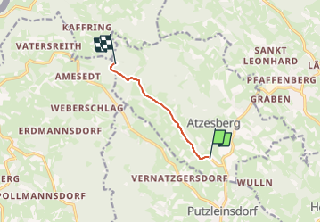
![](/images/other/stat-length.png)
![Trail On foot Atzesberg - Hanriederweg - Photo](https://media.geolcdn.com/t/1900/400/ext.pjpeg?maxdim=2&url=https%3A%2F%2Fstatic1.geolcdn.com%2Fsiteimages%2Fupload%2Ffiles%2F1545311037marcheuse_200dpi.jpg)
Hanriederweg
SityTrail - itinéraires balisés pédestres
Tous les sentiers balisés d’Europe GUIDE+
![Length](/images/other/stat-length.png)
![Max alt](https://static1.geolcdn.com/siteimages/upload/files/1508320355ic_sort_altitude_max_24dp.png)
![Uphill gradient](https://static1.geolcdn.com/siteimages/upload/files/1508320355ic_sort_den_pos_24dp.png)
![Km-Effort](/images/other/stat-length.png)
![Min alt](https://static1.geolcdn.com/siteimages/upload/files/1508320355ic_sort_altitude_min_24dp.png)
![Downhill gradient](https://static1.geolcdn.com/siteimages/upload/files/1508320355ic_sort_den_neg_24dp.png)
![Boucle](https://static1.geolcdn.com/siteimages/upload/files/16400158638029165_repeat_loop_refresh_sync_direction_icon.png)
![On foot](https://static1.geolcdn.com/sitytour/trail-icons/100.png)
1h43
Difficulty : Easy
![Scan this QR Code to open this trail in the SityTrail application](https://capi.geolives.com/qq0zvz2zws4bq2lad0pu/sitytour/trails/3125910/qr.png?size=200)
FREE GPS app for hiking
About
Trail On foot of 4.4 km to be discovered at Upper Austria, Bezirk Rohrbach, Atzesberg. This trail is proposed by SityTrail - itinéraires balisés pédestres.
Description
Hanriederweg in Kollerschlag. Schöne Wanderung mit herrlichen Ausblicken. Wandern im Böhmerwald, in der Ferienregion Böhmerwald im Dreiländereck Österreich, Deutschland und Tschechien, 15 km.
Website: https://www.boehmerwald.at/oesterreich/tour/430000307/15-km-hanriederweg.html
Positioning
Comments
Trails nearby
![Trail On foot Sarleinsbach - Lebensblickeweg - Photo](https://media.geolcdn.com/t/375/260/c2ab6ddc-4324-46f6-9585-fd0da08580f7.jpeg&format=jpg&maxdim=2)
![On foot On foot](https://static1.geolcdn.com/sitytour/trail-icons/100.png)
On foot
![](/images/other/stat-length.png)
![](https://static1.geolcdn.com/siteimages/upload/files/16400158638029165_repeat_loop_refresh_sync_direction_icon.png)
![Trail On foot Lembach im Mühlkreis - Leinenweberweg - Photo](https://media.geolcdn.com/t/375/260/f4205c2e-8789-4cca-b6b5-6da8a05a147e.jpeg&format=jpg&maxdim=2)
![On foot On foot](https://static1.geolcdn.com/sitytour/trail-icons/100.png)
On foot
![](/images/other/stat-length.png)
![](https://static1.geolcdn.com/siteimages/upload/files/16400158638029165_repeat_loop_refresh_sync_direction_icon.png)