Trail On foot Koszalin - Ścieżka Edukacyjna - Photo

Tous les sentiers balisés d’Europe PRO

© OpenStreetMap contributors
Length
Length
5.3 km
Max alt
Max alt
124 m
Uphill gradient
Uphill gradient
112 m
Km-Effort
Km-Effort  
6.8 km
Min alt
Min alt
77 m
Downhill gradient
Downhill gradient
107 m
Boucle
Boucle
Yes
Signpost
Signpost
Creation date :
2022-02-16 16:05:36.777
Updated on :
2022-03-08 10:56:35.709

(0 Reviews)

On foot
On foot
1h32
Difficulty : Easy

Scan this QR Code to open this trail in the SityTrail application

FREE GPS app for hiking

Logo SityTrail SityTrail

IGN / Geographical institutes

Download SityTrail from the App Store Download SityTrail from Google Play

Logo SityTrail SityTrail World

The world is yours!

Download SityTrail from the App Store Download SityTrail from Google Play Download SityTrail on Huawei AppGallery

About

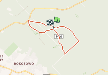
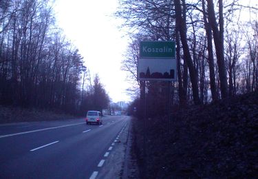
Trail On foot of 5.3 km to be discovered at West Pomeranian Voivodeship, Koszalin, Koszalin. This trail is proposed by SityTrail - itinéraires balisés pédestres.

Description

Symbol: dwa maszerujące ludziki; drogowskazy nie szlaki

Positioning

Country:
Poland
Region :
West Pomeranian Voivodeship
Department/Province :
Koszalin
Municipality :
Koszalin
Location:
Unknown
Start:(UTM)
581491 ; 6006889 (33U) N.

Trails nearby

Trail On foot Koszalin - Szlak Porwanego Księcia - Photo
On foot
PRO

On foot

Easy
Koszalin, West Pomeranian Voivodeship, Koszalin, Poland
10.8 km | 13 km-effort
2h 57min
No
Trail On foot Koszalin - Pętla Tatrzańska - Photo
On foot
PRO

On foot

Easy
Koszalin, West Pomeranian Voivodeship, Koszalin, Poland
10.8 km | 13.5 km-effort
3h 4min
No
Trail On foot Koszalin - Ścieżka przyrodniczo-edukacyjna
On foot
PRO

On foot

Easy
Koszalin, West Pomeranian Voivodeship, Koszalin, Poland
10.7 km | 13 km-effort
2h 57min
No
Trail On foot Koszalin - Szlak Kamieni Granicznych - Photo
On foot
PRO

On foot

Easy
Koszalin, West Pomeranian Voivodeship, Koszalin, Poland
14.5 km | 17.7 km-effort
4h 0min
No


Close
My subscriptions