![](/images/other/stat-length.png)
![Trail On foot Kefermarkt - Burgen- und Schlösserweg - Photo](https://media.geolcdn.com/t/1900/400/68b05141-0c23-4fe5-b237-d42b62a9e6fe.jpeg&format=pjpeg&maxdim=2)
Burgen- und Schlösserweg
SityTrail - itinéraires balisés pédestres
Tous les sentiers balisés d’Europe GUIDE+
![Length](/images/other/stat-length.png)
Length
16.8 km
![Max alt](https://static1.geolcdn.com/siteimages/upload/files/1508320355ic_sort_altitude_max_24dp.png)
Max alt
764 m
![Uphill gradient](https://static1.geolcdn.com/siteimages/upload/files/1508320355ic_sort_den_pos_24dp.png)
Uphill gradient
667 m
![Km-Effort](/images/other/stat-length.png)
Km-Effort
25 km
![Min alt](https://static1.geolcdn.com/siteimages/upload/files/1508320355ic_sort_altitude_min_24dp.png)
Min alt
501 m
![Downhill gradient](https://static1.geolcdn.com/siteimages/upload/files/1508320355ic_sort_den_neg_24dp.png)
Downhill gradient
461 m
![Boucle](https://static1.geolcdn.com/siteimages/upload/files/16400158638029165_repeat_loop_refresh_sync_direction_icon.png)
Boucle
No
Signpost
Creation date :
2022-02-16 16:05:29.398
Updated on :
2022-03-03 00:28:25.293
![On foot](https://static1.geolcdn.com/sitytour/trail-icons/100.png)
5h40
Difficulty : Medium
![Scan this QR Code to open this trail in the SityTrail application](https://capi.geolives.com/qq0zvz2zws4bq2lad0pu/sitytour/trails/3125865/qr.png?size=200)
FREE GPS app for hiking
About
Trail On foot of 16.8 km to be discovered at Upper Austria, Bezirk Freistadt, Kefermarkt. This trail is proposed by SityTrail - itinéraires balisés pédestres.
Description
Trail created by Gemeinde Gutau.
http://wiki.openstreetmap.org/wiki/WikiProject_Austria/Wanderwege
Symbol: Schild mit stilisierten Schlosstürmen in Schwarz auf orangem Grund
Positioning
Country:
Austria
Region :
Upper Austria
Department/Province :
Bezirk Freistadt
Municipality :
Kefermarkt
Location:
Unknown
Start:(Dec)
Start:(UTM)
467638 ; 5364910 (33U) N.
Comments
Trails nearby
![Trail On foot Lasberg - Mühlenweg - Photo](https://media.geolcdn.com/t/375/260/e818d116-b894-461c-8ced-d07ee935fca6.jpeg&format=jpg&maxdim=2)
![On foot On foot](https://static1.geolcdn.com/sitytour/trail-icons/100.png)
Mühlenweg
On foot
Easy
Lasberg,
Upper Austria,
Bezirk Freistadt,
Austria
![](/images/other/stat-length.png)
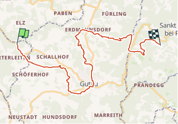
8.1 km | 11 km-effort
2h 30min
![](https://static1.geolcdn.com/siteimages/upload/files/16400158638029165_repeat_loop_refresh_sync_direction_icon.png)
Yes
![Trail On foot Lasberg - Elzer-Weg - Photo](https://media.geolcdn.com/t/375/260/4109331c-b27b-485c-b5b7-0b35754deafc.jpeg&format=jpg&maxdim=2)
![On foot On foot](https://static1.geolcdn.com/sitytour/trail-icons/100.png)
Elzer-Weg
On foot
Easy
Lasberg,
Upper Austria,
Bezirk Freistadt,
Austria
![](/images/other/stat-length.png)
3.6 km | 6.1 km-effort
1h 22min
![](https://static1.geolcdn.com/siteimages/upload/files/16400158638029165_repeat_loop_refresh_sync_direction_icon.png)
No
![Trail On foot Kefermarkt - Buchbergweg - Photo](https://media.geolcdn.com/t/375/260/78387aa7-1c3a-469e-88f6-c21fd54182d9.jpeg&format=jpg&maxdim=2)
![On foot On foot](https://static1.geolcdn.com/sitytour/trail-icons/100.png)
Buchbergweg
On foot
Easy
Kefermarkt,
Upper Austria,
Bezirk Freistadt,
Austria
![](/images/other/stat-length.png)
3.4 km | 6.1 km-effort
1h 23min
![](https://static1.geolcdn.com/siteimages/upload/files/16400158638029165_repeat_loop_refresh_sync_direction_icon.png)
No
![Trail On foot Lasberg - Vier-Berge-Weg - Photo](https://media.geolcdn.com/t/375/260/92dcbc28-8e43-4a92-890f-a960fb42af3f.jpeg&format=jpg&maxdim=2)
![On foot On foot](https://static1.geolcdn.com/sitytour/trail-icons/100.png)
Vier-Berge-Weg
On foot
Difficult
Lasberg,
Upper Austria,
Bezirk Freistadt,
Austria
![](/images/other/stat-length.png)
25 km | 38 km-effort
8h 32min
![](https://static1.geolcdn.com/siteimages/upload/files/16400158638029165_repeat_loop_refresh_sync_direction_icon.png)
Yes
![Trail On foot Gutau - Rundweg Gutau - Photo](https://media.geolcdn.com/t/375/260/5cba10fb-0063-4fb1-a15c-29938a1250d9.jpeg&format=jpg&maxdim=2)
![On foot On foot](https://static1.geolcdn.com/sitytour/trail-icons/100.png)
Rundweg Gutau
On foot
Easy
Gutau,
Upper Austria,
Bezirk Freistadt,
Austria
![](/images/other/stat-length.png)
11.5 km | 15.9 km-effort
3h 36min
![](https://static1.geolcdn.com/siteimages/upload/files/16400158638029165_repeat_loop_refresh_sync_direction_icon.png)
No
![Trail On foot Kefermarkt - Grüblweg - Photo](https://media.geolcdn.com/t/375/260/ext.jpg?maxdim=2&url=https%3A%2F%2Fstatic1.geolcdn.com%2Fsiteimages%2Fupload%2Ffiles%2F1545311037marcheuse_200dpi.jpg)
![On foot On foot](https://static1.geolcdn.com/sitytour/trail-icons/100.png)
Grüblweg
On foot
Easy
Kefermarkt,
Upper Austria,
Bezirk Freistadt,
Austria
![](/images/other/stat-length.png)
3.4 km | 4.4 km-effort
59min
![](https://static1.geolcdn.com/siteimages/upload/files/16400158638029165_repeat_loop_refresh_sync_direction_icon.png)
No