Trail On foot Valle Cannobina - S19 Falmenta - Alpe Fornà - Piè di Zeda - Photo

S19 Falmenta - Alpe Fornà - Piè di Zeda

Tous les sentiers balisés d’Europe GUIDE+

© OpenStreetMap contributors
Length
Length
7.7 km
Max alt
Max alt
1817 m
Uphill gradient
Uphill gradient
1191 m
Km-Effort
Km-Effort  
19.8 km
Min alt
Min alt
681 m
Downhill gradient
Downhill gradient
75 m
Boucle
Boucle
No
Signpost
Signpost
Creation date :
2022-02-15 19:08:20.164
Updated on :
2022-03-01 23:38:51.463

(0 Reviews)

On foot
On foot
4h30
Difficulty : Easy

Scan this QR Code to open this trail in the SityTrail application

FREE GPS app for hiking

Logo SityTrail SityTrail

IGN / Geographical institutes

Download SityTrail from the App Store Download SityTrail from Google Play

Logo SityTrail SityTrail World

The world is yours!

Download SityTrail from the App Store Download SityTrail from Google Play Download SityTrail on Huawei AppGallery

About

Trail On foot of 7.7 km to be discovered at Piemont, Verbano-Cusio-Ossola, Valle Cannobina. This trail is proposed by SityTrail - itinéraires balisés pédestres.

Description

Report maintained by path detectors CAI SOSEC Piemonte - MT RC

Symbol: white red flag

Elevation profile

Photos

Positioning

Country:
Italy
Region :
Piemont
Department/Province :
Verbano-Cusio-Ossola
Municipality :
Valle Cannobina
Location:
Unknown
Start:(UTM)
468135 ; 5102168 (32T) N.

Trails nearby

Trail On foot Valle Cannobina - S14 Orasso - Alpe Pluni - Photo
On foot
GUIDE+

On foot

Easy
Valle Cannobina, Piemont, Verbano-Cusio-Ossola, Italy
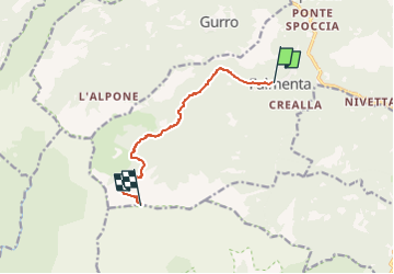
4.2 km | 12.8 km-effort
2h 54min
No
Trail On foot Valle Cannobina - S10 Cavaglio - Le Biuse - Monte Limidario - Photo
On foot
GUIDE+

On foot

Medium
Valle Cannobina, Piemont, Verbano-Cusio-Ossola, Italy
9.2 km | 26 km-effort
5h 54min
No
Trail On foot Cannobio - S01 Socraggiolo - Finero - Photo
On foot
GUIDE+

On foot

Difficult
Cannobio, Piemont, Verbano-Cusio-Ossola, Italy
15.6 km | 32 km-effort
7h 22min
No
Trail On foot Valle Cannobina - (SI E69) Falmenta - Cannobio - Photo
On foot
GUIDE+

On foot

Medium
Valle Cannobina, Piemont, Verbano-Cusio-Ossola, Italy
13.3 km | 21 km-effort
4h 46min
No
Trail On foot Valle Cannobina - S16 Cursolo - Alpe Pluni - Photo
On foot
GUIDE+

On foot

Easy
Valle Cannobina, Piemont, Verbano-Cusio-Ossola, Italy
3.4 km | 9.4 km-effort
2h 7min
No
Trail On foot Valle Cannobina - S08 Cavaglio - Monte Giove - Photo
On foot
GUIDE+

On foot

Easy
Valle Cannobina, Piemont, Verbano-Cusio-Ossola, Italy
4.3 km | 12.7 km-effort
2h 53min
No
Trail On foot Valle Cannobina - S12 Orasso - Bugnago - Spoccia - Photo
On foot
GUIDE+

On foot

Easy
Valle Cannobina, Piemont, Verbano-Cusio-Ossola, Italy
5.8 km | 11.1 km-effort
2h 30min
No
Trail On foot Gurro - S21 Gurro loc. Tresco, bivio S01 - La Piota - Photo
On foot
GUIDE+

On foot

Easy
Gurro, Piemont, Verbano-Cusio-Ossola, Italy
5.1 km | 14 km-effort
3h 10min
No
Trail On foot Valle Cannobina - S17 Falmenta - Cresta est Monte Vadà bivio R19 - Photo
On foot
GUIDE+

On foot

Easy
Valle Cannobina, Piemont, Verbano-Cusio-Ossola, Italy
6 km | 17.5 km-effort
3h 58min
No


Close
My subscriptions