![](/images/other/stat-length.png)
![Trail On foot Manzat - Aux Sources de la Morge - Photo](https://media.geolcdn.com/t/1900/400/5410179d-bc75-4fce-aa40-6165831bf324.jpeg&format=pjpeg&maxdim=2)
Aux Sources de la Morge
SityTrail - itinéraires balisés pédestres
Tous les sentiers balisés d’Europe GUIDE+
![Length](/images/other/stat-length.png)
Length
16.3 km
![Max alt](https://static1.geolcdn.com/siteimages/upload/files/1508320355ic_sort_altitude_max_24dp.png)
Max alt
902 m
![Uphill gradient](https://static1.geolcdn.com/siteimages/upload/files/1508320355ic_sort_den_pos_24dp.png)
Uphill gradient
474 m
![Km-Effort](/images/other/stat-length.png)
Km-Effort
23 km
![Min alt](https://static1.geolcdn.com/siteimages/upload/files/1508320355ic_sort_altitude_min_24dp.png)
Min alt
616 m
![Downhill gradient](https://static1.geolcdn.com/siteimages/upload/files/1508320355ic_sort_den_neg_24dp.png)
Downhill gradient
478 m
![Boucle](https://static1.geolcdn.com/siteimages/upload/files/16400158638029165_repeat_loop_refresh_sync_direction_icon.png)
Boucle
Yes
Signpost
Creation date :
2022-02-15 19:07:00.038
Updated on :
2022-03-02 22:52:23.449
![On foot](https://static1.geolcdn.com/sitytour/trail-icons/100.png)
5h08
Difficulty : Medium
![Scan this QR Code to open this trail in the SityTrail application](https://capi.geolives.com/qq0zvz2zws4bq2lad0pu/sitytour/trails/3124307/qr.png?size=200)
FREE GPS app for hiking
About
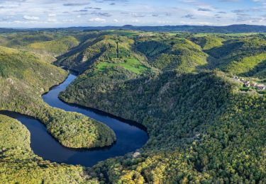
Trail On foot of 16.3 km to be discovered at Auvergne-Rhône-Alpes, Puy-de-Dôme, Manzat. This trail is proposed by SityTrail - itinéraires balisés pédestres.
Description
Trail created by CD63.
Positioning
Country:
France
Region :
Auvergne-Rhône-Alpes
Department/Province :
Puy-de-Dôme
Municipality :
Manzat
Location:
Unknown
Start:(Dec)
Start:(UTM)
493337 ; 5086642 (31T) N.
Comments
Trails nearby
![Trail On foot Chapdes-Beaufort - Le Chemin Fais'Art - Photo](https://media.geolcdn.com/t/375/260/6a67584d-6d2a-4686-9980-b00966620a6c.jpeg&format=jpg&maxdim=2)
![On foot On foot](https://static1.geolcdn.com/sitytour/trail-icons/100.png)
Le Chemin Fais'Art
On foot
Easy
Chapdes-Beaufort,
Auvergne-Rhône-Alpes,
Puy-de-Dôme,
France
![](/images/other/stat-length.png)
6.5 km | 8.6 km-effort
1h 57min
![](https://static1.geolcdn.com/siteimages/upload/files/16400158638029165_repeat_loop_refresh_sync_direction_icon.png)
Yes
![Trail On foot Queuille - Bois de Motaillas - Photo](https://media.geolcdn.com/t/375/260/078844af-a0a5-4551-8bac-d787e0bf10fc.jpeg&format=jpg&maxdim=2)
![On foot On foot](https://static1.geolcdn.com/sitytour/trail-icons/100.png)
Bois de Motaillas
On foot
Easy
Queuille,
Auvergne-Rhône-Alpes,
Puy-de-Dôme,
France
![](/images/other/stat-length.png)
4.6 km | 7.9 km-effort
1h 48min
![](https://static1.geolcdn.com/siteimages/upload/files/16400158638029165_repeat_loop_refresh_sync_direction_icon.png)
Yes
![Trail Walking Queuille - Queuille_Meandre_Sioule_1 - Photo](https://media.geolcdn.com/t/375/260/ad87324e-b040-4162-a113-54c4bbf0c5ae.jpeg&format=jpg&maxdim=2)
![Walking Walking](https://static1.geolcdn.com/sitytour/trail-icons/101.png)
Queuille_Meandre_Sioule_1
Walking
Easy
Queuille,
Auvergne-Rhône-Alpes,
Puy-de-Dôme,
France
![](/images/other/stat-length.png)
8.4 km | 11.4 km-effort
2h 30min
![](https://static1.geolcdn.com/siteimages/upload/files/16400158638029165_repeat_loop_refresh_sync_direction_icon.png)
No
![Trail Walking Chapdes-Beaufort - Le Mazal ,le chemin fais’art, la vierge de Beaufort - Photo](https://media.geolcdn.com/t/375/260/e753b7dd-2c61-4107-866d-ec27713cf357.jpg&format=jpg&maxdim=2)
![Walking Walking](https://static1.geolcdn.com/sitytour/trail-icons/101.png)
Le Mazal ,le chemin fais’art, la vierge de Beaufort
Walking
Medium
Chapdes-Beaufort,
Auvergne-Rhône-Alpes,
Puy-de-Dôme,
France
![](/images/other/stat-length.png)
21 km | 28 km-effort
5h 23min
![](https://static1.geolcdn.com/siteimages/upload/files/16400158638029165_repeat_loop_refresh_sync_direction_icon.png)
Yes
![Trail On foot Saint-Georges-de-Mons - Les Meandres de Queuillle - Photo](https://media.geolcdn.com/t/375/260/078844af-a0a5-4551-8bac-d787e0bf10fc.jpeg&format=jpg&maxdim=2)
![On foot On foot](https://static1.geolcdn.com/sitytour/trail-icons/100.png)
Les Meandres de Queuillle
On foot
Easy
Saint-Georges-de-Mons,
Auvergne-Rhône-Alpes,
Puy-de-Dôme,
France
![](/images/other/stat-length.png)
11.7 km | 16.7 km-effort
3h 47min
![](https://static1.geolcdn.com/siteimages/upload/files/16400158638029165_repeat_loop_refresh_sync_direction_icon.png)
Yes
![Trail On foot Manzat - La Roche de Sauterre - Photo](https://media.geolcdn.com/t/375/260/8dba4542-9ef0-4bdf-8b1f-a5675463ca16.jpeg&format=jpg&maxdim=2)
![On foot On foot](https://static1.geolcdn.com/sitytour/trail-icons/100.png)
La Roche de Sauterre
On foot
Easy
Manzat,
Auvergne-Rhône-Alpes,
Puy-de-Dôme,
France
![](/images/other/stat-length.png)
4.2 km | 5.8 km-effort
1h 18min
![](https://static1.geolcdn.com/siteimages/upload/files/16400158638029165_repeat_loop_refresh_sync_direction_icon.png)
Yes
![Trail Walking Charbonnières-les-Varennes - Le Puy de Paugnat - Photo](https://media.geolcdn.com/t/375/260/b631891c-a86d-4ad8-811c-e5b56ec82195.jpg&format=jpg&maxdim=2)
![Walking Walking](https://static1.geolcdn.com/sitytour/trail-icons/101.png)
Le Puy de Paugnat
Walking
Medium
Charbonnières-les-Varennes,
Auvergne-Rhône-Alpes,
Puy-de-Dôme,
France
![](/images/other/stat-length.png)
10.7 km | 13.9 km-effort
2h 40min
![](https://static1.geolcdn.com/siteimages/upload/files/16400158638029165_repeat_loop_refresh_sync_direction_icon.png)
Yes
![Trail Walking Chapdes-Beaufort - Chapdes_Chemin_Fais_Art - Photo](https://media.geolcdn.com/t/375/260/f84975b9-7ed1-4275-9bbc-b1be600b480e.jpg&format=jpg&maxdim=2)
![Walking Walking](https://static1.geolcdn.com/sitytour/trail-icons/101.png)
Chapdes_Chemin_Fais_Art
Walking
Easy
Chapdes-Beaufort,
Auvergne-Rhône-Alpes,
Puy-de-Dôme,
France
![](/images/other/stat-length.png)
6.9 km | 9.2 km-effort
2h 0min
![](https://static1.geolcdn.com/siteimages/upload/files/16400158638029165_repeat_loop_refresh_sync_direction_icon.png)
Yes
![Trail Walking Chapdes-Beaufort - Chapdes_Vierge_Beaufort - Photo](https://media.geolcdn.com/t/375/260/35b8fbd4-52ea-464d-9aaa-ed120d1657e8.jpg&format=jpg&maxdim=2)
![Walking Walking](https://static1.geolcdn.com/sitytour/trail-icons/101.png)
Chapdes_Vierge_Beaufort
Walking
Medium
Chapdes-Beaufort,
Auvergne-Rhône-Alpes,
Puy-de-Dôme,
France
![](/images/other/stat-length.png)
10.8 km | 14.9 km-effort
3h 15min
![](https://static1.geolcdn.com/siteimages/upload/files/16400158638029165_repeat_loop_refresh_sync_direction_icon.png)
Yes