![](/images/other/stat-length.png)
![Trail On foot Vieux-Habitants - Trois Crêtes par la Vallée de Beaugendre - Photo](https://media.geolcdn.com/t/1900/400/ext.pjpeg?maxdim=2&url=https%3A%2F%2Fstatic1.geolcdn.com%2Fsiteimages%2Fupload%2Ffiles%2F1545311037marcheuse_200dpi.jpg)
Trois Crêtes par la Vallée de Beaugendre
SityTrail - itinéraires balisés pédestres
Tous les sentiers balisés d’Europe GUIDE+
![Length](/images/other/stat-length.png)
Length
3.1 km
![Max alt](https://static1.geolcdn.com/siteimages/upload/files/1508320355ic_sort_altitude_max_24dp.png)
Max alt
904 m
![Uphill gradient](https://static1.geolcdn.com/siteimages/upload/files/1508320355ic_sort_den_pos_24dp.png)
Uphill gradient
60 m
![Km-Effort](/images/other/stat-length.png)
Km-Effort
5.6 km
![Min alt](https://static1.geolcdn.com/siteimages/upload/files/1508320355ic_sort_altitude_min_24dp.png)
Min alt
397 m
![Downhill gradient](https://static1.geolcdn.com/siteimages/upload/files/1508320355ic_sort_den_neg_24dp.png)
Downhill gradient
553 m
![Boucle](https://static1.geolcdn.com/siteimages/upload/files/16400158638029165_repeat_loop_refresh_sync_direction_icon.png)
Boucle
No
Signpost
Creation date :
2022-02-15 17:49:22.269
Updated on :
2022-03-02 19:58:06.539
![On foot](https://static1.geolcdn.com/sitytour/trail-icons/100.png)
1h15
Difficulty : Easy
![Scan this QR Code to open this trail in the SityTrail application](https://capi.geolives.com/qq0zvz2zws4bq2lad0pu/sitytour/trails/3122943/qr.png?size=200)
FREE GPS app for hiking
About
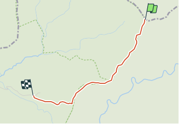
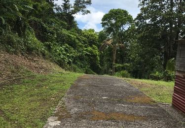
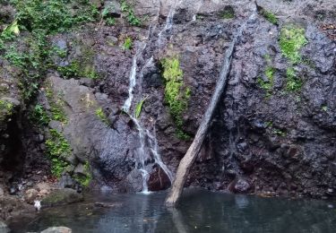
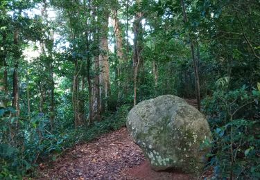
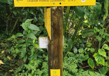
Trail On foot of 3.1 km to be discovered at Guadeloupe, Unknown, Vieux-Habitants. This trail is proposed by SityTrail - itinéraires balisés pédestres.
Description
Trail created by Parc National de la Guadeloupe.
Website: http://www.randoguadeloupe.gp/pedestre/trois-cretes-par-la-vallee-de-beaugendre/
Positioning
Country:
France
Region :
Guadeloupe
Department/Province :
Unknown
Municipality :
Vieux-Habitants
Location:
Unknown
Start:(Dec)
Start:(UTM)
637834 ; 1782311 (20Q) N.
Comments
Trails nearby
![Trail Walking Bouillante - Trou à Diable par la rivière Bourceau - Photo](https://media.geolcdn.com/t/375/260/cb844bd4-dbec-4a42-90d5-af2dc03f38f3.jpg&format=jpg&maxdim=2)
![Walking Walking](https://static1.geolcdn.com/sitytour/trail-icons/101.png)
Trou à Diable par la rivière Bourceau
Walking
Easy
Bouillante,
Guadeloupe,
Unknown,
France
![](/images/other/stat-length.png)
12 km | 18.4 km-effort
3h 22min
![](https://static1.geolcdn.com/siteimages/upload/files/16400158638029165_repeat_loop_refresh_sync_direction_icon.png)
No
![Trail Walking Vieux-Habitants - Cascade de Beaugendre - Photo](https://media.geolcdn.com/t/375/260/557f99cc-62e2-463d-96a8-15be0c843d04.jpg&format=jpg&maxdim=2)
![Walking Walking](https://static1.geolcdn.com/sitytour/trail-icons/101.png)
Cascade de Beaugendre
Walking
Very easy
(1)
Vieux-Habitants,
Guadeloupe,
Unknown,
France
![](/images/other/stat-length.png)
7 km | 11 km-effort
2h 31min
![](https://static1.geolcdn.com/siteimages/upload/files/16400158638029165_repeat_loop_refresh_sync_direction_icon.png)
Yes
![Trail Walking Bouillante - Trou à Diable - Photo](https://media.geolcdn.com/t/375/260/fa583ba2-214f-4694-a649-d86763bb0df5.jpg&format=jpg&maxdim=2)
![Walking Walking](https://static1.geolcdn.com/sitytour/trail-icons/101.png)
Trou à Diable
Walking
Easy
(1)
Bouillante,
Guadeloupe,
Unknown,
France
![](/images/other/stat-length.png)
3.8 km | 5.9 km-effort
1h 22min
![](https://static1.geolcdn.com/siteimages/upload/files/16400158638029165_repeat_loop_refresh_sync_direction_icon.png)
Yes
![Trail On foot Vieux-Habitants - Beaugendre-Village - Photo](https://media.geolcdn.com/t/375/260/f0dd5f5e-7417-4b73-8269-653df218f49a.jpg&format=jpg&maxdim=2)
![On foot On foot](https://static1.geolcdn.com/sitytour/trail-icons/100.png)
Beaugendre-Village
On foot
Medium
Vieux-Habitants,
Guadeloupe,
Unknown,
France
![](/images/other/stat-length.png)
12.3 km | 27 km-effort
6h 6min
![](https://static1.geolcdn.com/siteimages/upload/files/16400158638029165_repeat_loop_refresh_sync_direction_icon.png)
No
![Trail Other activity Vieux-Habitants - grand camp - Photo](https://media.geolcdn.com/t/375/260/ext.jpg?maxdim=2&url=https%3A%2F%2Fservices.sitytrail.com%2FGeolivesWS%2FDownloadMedia.ashx%3FTrailID%3D1004700%26Media%3D20180420130314.jpg)
![Other activity Other activity](https://static1.geolcdn.com/sitytour/trail-icons/900.png)
grand camp
Other activity
Very difficult
Vieux-Habitants,
Guadeloupe,
Unknown,
France
![](/images/other/stat-length.png)
25 km | 48 km-effort
13h 45min
![](https://static1.geolcdn.com/siteimages/upload/files/16400158638029165_repeat_loop_refresh_sync_direction_icon.png)
No
![Trail Walking Bouillante - Cascade rivière Espérance - Photo](https://media.geolcdn.com/t/375/260/912d895e-7f8a-4842-9d5c-7ca384895704.jpg&format=jpg&maxdim=2)
![Walking Walking](https://static1.geolcdn.com/sitytour/trail-icons/101.png)
Cascade rivière Espérance
Walking
Very easy
Bouillante,
Guadeloupe,
Unknown,
France
![](/images/other/stat-length.png)
1.5 km | 2.9 km-effort
47min
![](https://static1.geolcdn.com/siteimages/upload/files/16400158638029165_repeat_loop_refresh_sync_direction_icon.png)
Yes
![Trail Walking Bouillante - Crête des Bois - Photo](https://media.geolcdn.com/t/375/260/8f2ce386-98a5-41c2-8b18-7a0db1d6797f.jpg&format=jpg&maxdim=2)
![Walking Walking](https://static1.geolcdn.com/sitytour/trail-icons/101.png)
Crête des Bois
Walking
Medium
Bouillante,
Guadeloupe,
Unknown,
France
![](/images/other/stat-length.png)
3.9 km | 8.6 km-effort
1h 34min
![](https://static1.geolcdn.com/siteimages/upload/files/16400158638029165_repeat_loop_refresh_sync_direction_icon.png)
Yes
![Trail Walking Bouillante - Traces des 3 crêtes - Photo](https://media.geolcdn.com/t/375/260/56421d6a-c069-4456-a8e3-9aeedd521685.jpg&format=jpg&maxdim=2)
![Walking Walking](https://static1.geolcdn.com/sitytour/trail-icons/101.png)
Traces des 3 crêtes
Walking
Difficult
Bouillante,
Guadeloupe,
Unknown,
France
![](/images/other/stat-length.png)
9.4 km | 20 km-effort
6h 35min
![](https://static1.geolcdn.com/siteimages/upload/files/16400158638029165_repeat_loop_refresh_sync_direction_icon.png)
No
![Trail Nordic walking Bouillante - Piton bouillante 3 crêtes - Photo](https://media.geolcdn.com/t/375/260/ext.jpg?maxdim=2&url=https%3A%2F%2Fstatic1.geolcdn.com%2Fsiteimages%2Fupload%2Ffiles%2F1545311037marcheuse_200dpi.jpg)
![Nordic walking Nordic walking](https://static1.geolcdn.com/sitytour/trail-icons/102.png)
Piton bouillante 3 crêtes
Nordic walking
Very difficult
Bouillante,
Guadeloupe,
Unknown,
France
![](/images/other/stat-length.png)
10.6 km | 21 km-effort
7h 24min
![](https://static1.geolcdn.com/siteimages/upload/files/16400158638029165_repeat_loop_refresh_sync_direction_icon.png)
No