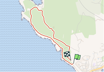
![](/images/other/stat-length.png)
![Trail On foot Martigues - Sentier botanique de la plaine de Carro - Photo](https://media.geolcdn.com/t/1900/400/6e507b0b-ffdb-4c7c-b8fe-ce4599d1b5df.jpeg&format=pjpeg&maxdim=2)
Sentier botanique de la plaine de Carro
SityTrail - itinéraires balisés pédestres
Tous les sentiers balisés d’Europe GUIDE+
![Length](/images/other/stat-length.png)
![Max alt](https://static1.geolcdn.com/siteimages/upload/files/1508320355ic_sort_altitude_max_24dp.png)
![Uphill gradient](https://static1.geolcdn.com/siteimages/upload/files/1508320355ic_sort_den_pos_24dp.png)
![Km-Effort](/images/other/stat-length.png)
![Min alt](https://static1.geolcdn.com/siteimages/upload/files/1508320355ic_sort_altitude_min_24dp.png)
![Downhill gradient](https://static1.geolcdn.com/siteimages/upload/files/1508320355ic_sort_den_neg_24dp.png)
![Boucle](https://static1.geolcdn.com/siteimages/upload/files/16400158638029165_repeat_loop_refresh_sync_direction_icon.png)
![On foot](https://static1.geolcdn.com/sitytour/trail-icons/100.png)
58m
Difficulty : Easy
![Scan this QR Code to open this trail in the SityTrail application](https://capi.geolives.com/qq0zvz2zws4bq2lad0pu/sitytour/trails/3122473/qr.png?size=200)
FREE GPS app for hiking
About
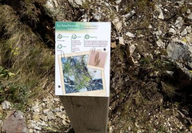
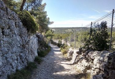
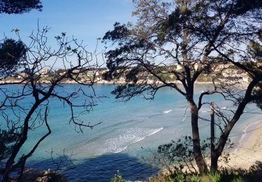
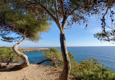
Trail On foot of 3.9 km to be discovered at Provence-Alpes-Côte d'Azur, Bouches-du-Rhône, Martigues. This trail is proposed by SityTrail - itinéraires balisés pédestres.
Description
Préparez votre séjour dans les Bouches-du Rhône. My Provence a sélectionné pour vous le meilleur de l'offre touristique du département.
Website: https://www.myprovence.fr/circuits/randonnees/martigues/146282-sentier-botanique-de-la-plaine-de-carro
Positioning
Comments
Trails nearby
![Walking Walking](https://static1.geolcdn.com/sitytour/trail-icons/101.png)
Walking
![](/images/other/stat-length.png)
![](https://static1.geolcdn.com/siteimages/upload/files/16400158638029165_repeat_loop_refresh_sync_direction_icon.png)
![Trail Walking Martigues - Cap couronne - Photo](https://media.geolcdn.com/t/375/260/a311f26f-67e9-4722-b5dc-a3c3bf8cdd1f.jpg&format=jpg&maxdim=2)
![Walking Walking](https://static1.geolcdn.com/sitytour/trail-icons/101.png)
Walking
![](/images/other/stat-length.png)
![](https://static1.geolcdn.com/siteimages/upload/files/16400158638029165_repeat_loop_refresh_sync_direction_icon.png)
![Trail On foot Martigues - Sentier du littoral Martégal - Photo](https://media.geolcdn.com/t/375/260/f31fb86f-0853-4030-a971-6f7cd6c75f73.jpeg&format=jpg&maxdim=2)
![On foot On foot](https://static1.geolcdn.com/sitytour/trail-icons/100.png)
On foot
![](/images/other/stat-length.png)
![](https://static1.geolcdn.com/siteimages/upload/files/16400158638029165_repeat_loop_refresh_sync_direction_icon.png)
![Trail On foot Martigues - Les carrières de pierre de La Couronne - Photo](https://media.geolcdn.com/t/375/260/26fea46b-0136-4e03-82e5-aa4d3d222ff5.jpeg&format=jpg&maxdim=2)
![On foot On foot](https://static1.geolcdn.com/sitytour/trail-icons/100.png)
On foot
![](/images/other/stat-length.png)
![](https://static1.geolcdn.com/siteimages/upload/files/16400158638029165_repeat_loop_refresh_sync_direction_icon.png)
![Trail On foot Martigues - Boucle de Boumandariel - Photo](https://media.geolcdn.com/t/375/260/952ba8e0-5d66-42a5-803d-b742aff43050.jpeg&format=jpg&maxdim=2)
![On foot On foot](https://static1.geolcdn.com/sitytour/trail-icons/100.png)
On foot
![](/images/other/stat-length.png)
![](https://static1.geolcdn.com/siteimages/upload/files/16400158638029165_repeat_loop_refresh_sync_direction_icon.png)
![Trail On foot Martigues - Le Cap Couronne - Photo](https://media.geolcdn.com/t/375/260/2e60c5c0-e67b-4759-bf81-6d72ec0d7ebf.jpeg&format=jpg&maxdim=2)
![On foot On foot](https://static1.geolcdn.com/sitytour/trail-icons/100.png)
On foot
![](/images/other/stat-length.png)
![](https://static1.geolcdn.com/siteimages/upload/files/16400158638029165_repeat_loop_refresh_sync_direction_icon.png)
![Trail On foot Martigues - Mer et colline Valestéloué - Photo](https://media.geolcdn.com/t/375/260/21e84c92-a2fb-4448-a2ca-dfd7aed22fbc.jpeg&format=jpg&maxdim=2)
![On foot On foot](https://static1.geolcdn.com/sitytour/trail-icons/100.png)
On foot
![](/images/other/stat-length.png)
![](https://static1.geolcdn.com/siteimages/upload/files/16400158638029165_repeat_loop_refresh_sync_direction_icon.png)
![Trail Walking Martigues - Anse du Verdon- Carro-Ste Croix - Photo](https://media.geolcdn.com/t/375/260/b6a8c09e-d5e6-42ab-874c-3fd9a828030d.jpg&format=jpg&maxdim=2)
![Walking Walking](https://static1.geolcdn.com/sitytour/trail-icons/101.png)
Walking
![](/images/other/stat-length.png)
![](https://static1.geolcdn.com/siteimages/upload/files/16400158638029165_repeat_loop_refresh_sync_direction_icon.png)
![Trail Walking Martigues - Cap Couronne - Photo](https://media.geolcdn.com/t/375/260/f24bbda7-bec8-4767-80d7-37c4c3ad00bd.jpg&format=jpg&maxdim=2)
![Walking Walking](https://static1.geolcdn.com/sitytour/trail-icons/101.png)
Walking
![](/images/other/stat-length.png)
![](https://static1.geolcdn.com/siteimages/upload/files/16400158638029165_repeat_loop_refresh_sync_direction_icon.png)