Trail On foot Verghereto - IT-169 - Photo

Tous les sentiers balisés d’Europe GUIDE+

© OpenStreetMap contributors
Length
Length
7.7 km
Max alt
Max alt
1122 m
Uphill gradient
Uphill gradient
325 m
Km-Effort
Km-Effort  
12.3 km
Min alt
Min alt
749 m
Downhill gradient
Downhill gradient
403 m
Boucle
Boucle
No
Signpost
Signpost
Creation date :
2022-02-15 17:08:11.723
Updated on :
2022-03-01 19:54:39.25

(0 Reviews)

On foot
On foot
2h48
Difficulty : Easy

Scan this QR Code to open this trail in the SityTrail application

FREE GPS app for hiking

Logo SityTrail SityTrail

IGN / Geographical institutes

Download SityTrail from the App Store Download SityTrail from Google Play

Logo SityTrail SityTrail World

The world is yours!

Download SityTrail from the App Store Download SityTrail from Google Play Download SityTrail on Huawei AppGallery

About

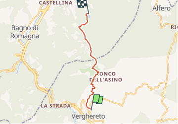
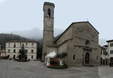
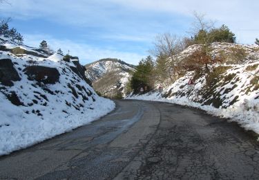
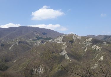
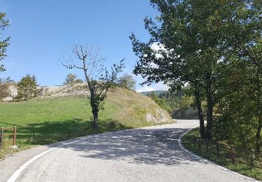
Trail On foot of 7.7 km to be discovered at Emilia-Romagna, Forlì-Cesena, Verghereto. This trail is proposed by SityTrail - itinéraires balisés pédestres.

Description

Trail created by Comune di Bagno di Romagna.

Symbol: 169 on white red flags

Elevation profile

Photos

Positioning

Country:
Italy
Region :
Emilia-Romagna
Department/Province :
Forlì-Cesena
Municipality :
Verghereto
Location:
Unknown
Start:(UTM)
259139 ; 4853551 (33T) N.

Trails nearby

Trail On foot Bagno di Romagna - IT-167B - Photo
On foot
GUIDE+

On foot

Easy
Bagno di Romagna, Emilia-Romagna, Forlì-Cesena, Italy
3.1 km | 5.9 km-effort
1h 20min
No
Trail On foot Bagno di Romagna - IT-161A - Photo
On foot
GUIDE+

On foot

Easy
Bagno di Romagna, Emilia-Romagna, Forlì-Cesena, Italy
4.1 km | 7.1 km-effort
1h 37min
No
Trail On foot Bagno di Romagna - IT-BT11 - Photo
On foot
GUIDE+

On foot

Easy
Bagno di Romagna, Emilia-Romagna, Forlì-Cesena, Italy
4 km | 8.6 km-effort
1h 56min
No
Trail On foot Verghereto - IT-141 - Photo
On foot
GUIDE+

On foot

Easy
Verghereto, Emilia-Romagna, Forlì-Cesena, Italy
4.6 km | 7.5 km-effort
1h 42min
No
Trail On foot Bagno di Romagna - Un viaggio nel tempo e nello spazio nell’Alto Savio - Photo
On foot
GUIDE+

On foot

Easy
Bagno di Romagna, Emilia-Romagna, Forlì-Cesena, Italy
7.1 km | 13.2 km-effort
2h 59min
No
Trail On foot Bagno di Romagna - Sul Monte Carpano da Bagno di Romagna - Photo
On foot
GUIDE+

On foot

Easy
Bagno di Romagna, Emilia-Romagna, Forlì-Cesena, Italy
10.8 km | 18.7 km-effort
4h 14min
Yes
Trail On foot Verghereto - IT-153 - Photo
On foot
GUIDE+

On foot

Easy
Verghereto, Emilia-Romagna, Forlì-Cesena, Italy
5.2 km | 7.4 km-effort
1h 40min
No
Trail On foot Verghereto - IT-102 - Photo
On foot
GUIDE+

On foot

Easy
Verghereto, Emilia-Romagna, Forlì-Cesena, Italy
4.2 km | 6.5 km-effort
1h 28min
No
Trail On foot Verghereto - (SI L04N) Verghereto - Badia Prataglia - Photo
On foot
GUIDE+

On foot

Medium
Verghereto, Emilia-Romagna, Forlì-Cesena, Italy
16.6 km | 28 km-effort
6h 24min
No


Close
My subscriptions