![](/images/other/stat-length.png)
![Trail On foot San Donato Val di Comino - Grotta Fondillo - Forca d'acero - Photo](https://media.geolcdn.com/t/1900/400/1a421610-3733-4a74-9caf-7e1374b5263b.jpeg&format=pjpeg&maxdim=2)
Grotta Fondillo - Forca d'acero
SityTrail - itinéraires balisés pédestres
Tous les sentiers balisés d’Europe GUIDE+
![Length](/images/other/stat-length.png)
Length
6.8 km
![Max alt](https://static1.geolcdn.com/siteimages/upload/files/1508320355ic_sort_altitude_max_24dp.png)
Max alt
1638 m
![Uphill gradient](https://static1.geolcdn.com/siteimages/upload/files/1508320355ic_sort_den_pos_24dp.png)
Uphill gradient
119 m
![Km-Effort](/images/other/stat-length.png)
Km-Effort
9.7 km
![Min alt](https://static1.geolcdn.com/siteimages/upload/files/1508320355ic_sort_altitude_min_24dp.png)
Min alt
1098 m
![Downhill gradient](https://static1.geolcdn.com/siteimages/upload/files/1508320355ic_sort_den_neg_24dp.png)
Downhill gradient
539 m
![Boucle](https://static1.geolcdn.com/siteimages/upload/files/16400158638029165_repeat_loop_refresh_sync_direction_icon.png)
Boucle
No
Signpost
Creation date :
2022-02-15 17:05:23.447
Updated on :
2022-03-01 19:47:20.135
![On foot](https://static1.geolcdn.com/sitytour/trail-icons/100.png)
2h12
Difficulty : Easy
![Scan this QR Code to open this trail in the SityTrail application](https://capi.geolives.com/qq0zvz2zws4bq2lad0pu/sitytour/trails/3122156/qr.png?size=200)
FREE GPS app for hiking
About
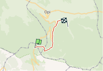
Trail On foot of 6.8 km to be discovered at Lazio, Frosinone, San Donato Val di Comino. This trail is proposed by SityTrail - itinéraires balisés pédestres.
Description
Symbol: F4 on white red flags
Positioning
Country:
Italy
Region :
Lazio
Department/Province :
Frosinone
Municipality :
San Donato Val di Comino
Location:
Unknown
Start:(Dec)
Start:(UTM)
401449 ; 4622509 (33T) N.
Comments
Trails nearby
![Trail On foot Opi - Acqua Sfranatara - Fonte San Cataldo - Photo](https://media.geolcdn.com/t/375/260/bd6b7374-b4fd-4418-8c89-b21e676fbe9d.jpeg&format=jpg&maxdim=2)
![On foot On foot](https://static1.geolcdn.com/sitytour/trail-icons/100.png)
Acqua Sfranatara - Fonte San Cataldo
On foot
Easy
Opi,
Abruzzo,
L'Aquila,
Italy
![](/images/other/stat-length.png)
8 km | 16.4 km-effort
3h 43min
![](https://static1.geolcdn.com/siteimages/upload/files/16400158638029165_repeat_loop_refresh_sync_direction_icon.png)
No
![Trail On foot Opi - Val Fondillo - Madonna Del Canneto - Photo](https://media.geolcdn.com/t/375/260/86102070-e5f8-4fd2-b9ab-d7d98a69cf57.jpeg&format=jpg&maxdim=2)
![On foot On foot](https://static1.geolcdn.com/sitytour/trail-icons/100.png)
Val Fondillo - Madonna Del Canneto
On foot
Medium
Opi,
Abruzzo,
L'Aquila,
Italy
![](/images/other/stat-length.png)
16 km | 25 km-effort
5h 35min
![](https://static1.geolcdn.com/siteimages/upload/files/16400158638029165_repeat_loop_refresh_sync_direction_icon.png)
No
![Trail On foot Opi - Grotta Fondillo - Monte Amaro - Photo](https://media.geolcdn.com/t/375/260/4039aa4b-6922-49fb-9723-94dca66e2869.jpeg&format=jpg&maxdim=2)
![On foot On foot](https://static1.geolcdn.com/sitytour/trail-icons/100.png)
Grotta Fondillo - Monte Amaro
On foot
Easy
Opi,
Abruzzo,
L'Aquila,
Italy
![](/images/other/stat-length.png)
3.2 km | 10.5 km-effort
2h 23min
![](https://static1.geolcdn.com/siteimages/upload/files/16400158638029165_repeat_loop_refresh_sync_direction_icon.png)
No
![Trail On foot Opi - Ponte Forcone - Monte Marsicano - Photo](https://media.geolcdn.com/t/375/260/4039aa4b-6922-49fb-9723-94dca66e2869.jpeg&format=jpg&maxdim=2)
![On foot On foot](https://static1.geolcdn.com/sitytour/trail-icons/100.png)
Ponte Forcone - Monte Marsicano
On foot
Easy
Opi,
Abruzzo,
L'Aquila,
Italy
![](/images/other/stat-length.png)
4.9 km | 16.2 km-effort
3h 40min
![](https://static1.geolcdn.com/siteimages/upload/files/16400158638029165_repeat_loop_refresh_sync_direction_icon.png)
No
![Trail On foot Opi - Le Casette - Monte Marsicano - Photo](https://media.geolcdn.com/t/375/260/4039aa4b-6922-49fb-9723-94dca66e2869.jpeg&format=jpg&maxdim=2)
![On foot On foot](https://static1.geolcdn.com/sitytour/trail-icons/100.png)
Le Casette - Monte Marsicano
On foot
Easy
Opi,
Abruzzo,
L'Aquila,
Italy
![](/images/other/stat-length.png)
5.7 km | 17 km-effort
3h 51min
![](https://static1.geolcdn.com/siteimages/upload/files/16400158638029165_repeat_loop_refresh_sync_direction_icon.png)
No
![Trail On foot Pescasseroli - Bocca del Petroso - SR509 di Forca D'Acero - Photo](https://media.geolcdn.com/t/375/260/8b335111-2316-44c1-84d8-5fd33b0994d9.jpeg&format=jpg&maxdim=2)
![On foot On foot](https://static1.geolcdn.com/sitytour/trail-icons/100.png)
Bocca del Petroso - SR509 di Forca D'Acero
On foot
Easy
Pescasseroli,
Abruzzo,
L'Aquila,
Italy
![](/images/other/stat-length.png)
11.2 km | 15.9 km-effort
3h 36min
![](https://static1.geolcdn.com/siteimages/upload/files/16400158638029165_repeat_loop_refresh_sync_direction_icon.png)
No
![Trail Walking Opi - monte Amaro Opi 9,5 km - Photo](https://media.geolcdn.com/t/375/260/ext.jpg?maxdim=2&url=https%3A%2F%2Fservices.sitytrail.com%2FGeolivesWS%2FDownloadMedia.ashx%3FTrailID%3D1003602%26Media%3D20180713125454.jpg)
![Walking Walking](https://static1.geolcdn.com/sitytour/trail-icons/101.png)
monte Amaro Opi 9,5 km
Walking
Medium
Opi,
Abruzzo,
L'Aquila,
Italy
![](/images/other/stat-length.png)
9.4 km | 19.5 km-effort
6h 55min
![](https://static1.geolcdn.com/siteimages/upload/files/16400158638029165_repeat_loop_refresh_sync_direction_icon.png)
Yes
![Trail Walking Opi - Anello val fondillo monte nicola valle fredda - Photo](https://media.geolcdn.com/t/375/260/00696b39-62ef-403f-9c0c-f9b710471e56.jpg&format=jpg&maxdim=2)
![Walking Walking](https://static1.geolcdn.com/sitytour/trail-icons/101.png)
Anello val fondillo monte nicola valle fredda
Walking
Opi,
Abruzzo,
L'Aquila,
Italy
![](/images/other/stat-length.png)
17.3 km | 28 km-effort
4h 34min
![](https://static1.geolcdn.com/siteimages/upload/files/16400158638029165_repeat_loop_refresh_sync_direction_icon.png)
Yes
![Trail On foot San Donato Val di Comino - Forca d'Acero - Valico Inguagnera - Photo](https://media.geolcdn.com/t/375/260/ext.jpg?maxdim=2&url=https%3A%2F%2Fstatic1.geolcdn.com%2Fsiteimages%2Fupload%2Ffiles%2F1545311037marcheuse_200dpi.jpg)
![On foot On foot](https://static1.geolcdn.com/sitytour/trail-icons/100.png)
Forca d'Acero - Valico Inguagnera
On foot
Easy
San Donato Val di Comino,
Lazio,
Frosinone,
Italy
![](/images/other/stat-length.png)
4.2 km | 8 km-effort
1h 49min
![](https://static1.geolcdn.com/siteimages/upload/files/16400158638029165_repeat_loop_refresh_sync_direction_icon.png)
No