![](/images/other/stat-length.png)
![Trail On foot Besançon - Le Cul des Prés - Photo](https://media.geolcdn.com/t/1900/400/045b13cf-68b2-486a-9167-14a694bb7739.jpeg&format=pjpeg&maxdim=2)
Le Cul des Prés
SityTrail - itinéraires balisés pédestres
Tous les sentiers balisés d’Europe GUIDE+
![Length](/images/other/stat-length.png)
Length
10.2 km
![Max alt](https://static1.geolcdn.com/siteimages/upload/files/1508320355ic_sort_altitude_max_24dp.png)
Max alt
376 m
![Uphill gradient](https://static1.geolcdn.com/siteimages/upload/files/1508320355ic_sort_den_pos_24dp.png)
Uphill gradient
190 m
![Km-Effort](/images/other/stat-length.png)
Km-Effort
12.7 km
![Min alt](https://static1.geolcdn.com/siteimages/upload/files/1508320355ic_sort_altitude_min_24dp.png)
Min alt
308 m
![Downhill gradient](https://static1.geolcdn.com/siteimages/upload/files/1508320355ic_sort_den_neg_24dp.png)
Downhill gradient
188 m
![Boucle](https://static1.geolcdn.com/siteimages/upload/files/16400158638029165_repeat_loop_refresh_sync_direction_icon.png)
Boucle
Yes
Signpost
Creation date :
2022-02-15 16:28:41.452
Updated on :
2022-03-02 18:37:05.014
![On foot](https://static1.geolcdn.com/sitytour/trail-icons/100.png)
2h53
Difficulty : Easy
![Scan this QR Code to open this trail in the SityTrail application](https://capi.geolives.com/qq0zvz2zws4bq2lad0pu/sitytour/trails/3121704/qr.png?size=200)
FREE GPS app for hiking
About
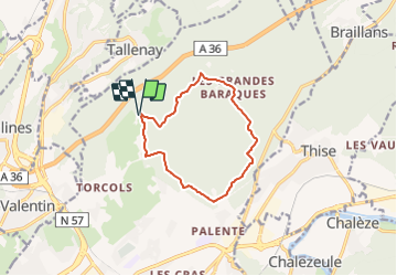
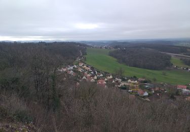
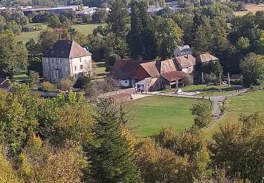
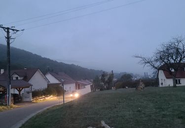
Trail On foot of 10.2 km to be discovered at Bourgogne-Franche-Comté, Doubs, Besançon. This trail is proposed by SityTrail - itinéraires balisés pédestres.
Description
Trail created by Ville de Besançon.
Website: http://www.grandes-heures-nature.fr/activites/les-randonnees-pedestres/
Positioning
Country:
France
Region :
Bourgogne-Franche-Comté
Department/Province :
Doubs
Municipality :
Besançon
Location:
Unknown
Start:(Dec)
Start:(UTM)
274927 ; 5241824 (32T) N.
Comments
Trails nearby
![Trail Walking Besançon - Colline de Besançon 29-08-2020 - Photo](https://media.geolcdn.com/t/375/260/1e155548-d400-46d3-8b28-207c9933a379.jpg&format=jpg&maxdim=2)
![Walking Walking](https://static1.geolcdn.com/sitytour/trail-icons/101.png)
Colline de Besançon 29-08-2020
Walking
Medium
(1)
Besançon,
Bourgogne-Franche-Comté,
Doubs,
France
![](/images/other/stat-length.png)
13.4 km | 17.7 km-effort
2h 46min
![](https://static1.geolcdn.com/siteimages/upload/files/16400158638029165_repeat_loop_refresh_sync_direction_icon.png)
Yes
![Trail On foot Thise - Sentier du Coutelot - Photo](https://media.geolcdn.com/t/375/260/afb256b5-7789-4ded-ae1d-d84139dab379.jpeg&format=jpg&maxdim=2)
![On foot On foot](https://static1.geolcdn.com/sitytour/trail-icons/100.png)
Sentier du Coutelot
On foot
Easy
Thise,
Bourgogne-Franche-Comté,
Doubs,
France
![](/images/other/stat-length.png)
9.1 km | 12.4 km-effort
2h 49min
![](https://static1.geolcdn.com/siteimages/upload/files/16400158638029165_repeat_loop_refresh_sync_direction_icon.png)
Yes
![Trail On foot Besançon - Dame Blanche et Vieux Tilleul - Photo](https://media.geolcdn.com/t/375/260/a831d8ab-a72b-4417-bd94-e54f01ff5dc4.jpeg&format=jpg&maxdim=2)
![On foot On foot](https://static1.geolcdn.com/sitytour/trail-icons/100.png)
Dame Blanche et Vieux Tilleul
On foot
Medium
Besançon,
Bourgogne-Franche-Comté,
Doubs,
France
![](/images/other/stat-length.png)
14.6 km | 20 km-effort
4h 36min
![](https://static1.geolcdn.com/siteimages/upload/files/16400158638029165_repeat_loop_refresh_sync_direction_icon.png)
Yes
![Trail Other activity Besançon - centre ville - Photo](https://media.geolcdn.com/t/375/260/ext.jpg?maxdim=2&url=https%3A%2F%2Fstatic1.geolcdn.com%2Fsiteimages%2Fupload%2Ffiles%2F1545311037marcheuse_200dpi.jpg)
![Other activity Other activity](https://static1.geolcdn.com/sitytour/trail-icons/900.png)
centre ville
Other activity
Very easy
(1)
Besançon,
Bourgogne-Franche-Comté,
Doubs,
France
![](/images/other/stat-length.png)
4.2 km | 4.9 km-effort
13min
![](https://static1.geolcdn.com/siteimages/upload/files/16400158638029165_repeat_loop_refresh_sync_direction_icon.png)
No
![Trail Mountain bike École-Valentin - marchaux dame blanche chatillon - Photo](https://media.geolcdn.com/t/375/260/ext.jpg?maxdim=2&url=https%3A%2F%2Fstatic1.geolcdn.com%2Fsiteimages%2Fupload%2Ffiles%2F1524743154velo.jpg)
![Mountain bike Mountain bike](https://static1.geolcdn.com/sitytour/trail-icons/202.png)
marchaux dame blanche chatillon
Mountain bike
Very easy
(2)
École-Valentin,
Bourgogne-Franche-Comté,
Doubs,
France
![](/images/other/stat-length.png)
35 km | 44 km-effort
Unknown
![](https://static1.geolcdn.com/siteimages/upload/files/16400158638029165_repeat_loop_refresh_sync_direction_icon.png)
Yes
![Trail Walking Devecey - devecey - Photo](https://media.geolcdn.com/t/375/260/e2eb8cdb-b528-42ec-8ea9-1c3aaa4eef69.jpg&format=jpg&maxdim=2)
![Walking Walking](https://static1.geolcdn.com/sitytour/trail-icons/101.png)
devecey
Walking
Easy
Devecey,
Bourgogne-Franche-Comté,
Doubs,
France
![](/images/other/stat-length.png)
12.3 km | 17.8 km-effort
5h 0min
![](https://static1.geolcdn.com/siteimages/upload/files/16400158638029165_repeat_loop_refresh_sync_direction_icon.png)
Yes
![Trail Walking Thise - Thise et sa Dame blanche - Photo](https://media.geolcdn.com/t/375/260/e57870fc-695b-4fa2-949a-ebb6a1ab9ba8.jpg&format=jpg&maxdim=2)
![Walking Walking](https://static1.geolcdn.com/sitytour/trail-icons/101.png)
Thise et sa Dame blanche
Walking
Very difficult
Thise,
Bourgogne-Franche-Comté,
Doubs,
France
![](/images/other/stat-length.png)
16.2 km | 23 km-effort
5h 7min
![](https://static1.geolcdn.com/siteimages/upload/files/16400158638029165_repeat_loop_refresh_sync_direction_icon.png)
Yes
![Trail Walking Devecey - 2022-10-11_18h19m13_SityTrail - 3419858 - devecey-baumes-version-2 - Photo](https://media.geolcdn.com/t/375/260/dc58287e-b527-4c6a-a894-f12edad59016.jpeg&format=jpg&maxdim=2)
![Walking Walking](https://static1.geolcdn.com/sitytour/trail-icons/101.png)
2022-10-11_18h19m13_SityTrail - 3419858 - devecey-baumes-version-2
Walking
Very difficult
Devecey,
Bourgogne-Franche-Comté,
Doubs,
France
![](/images/other/stat-length.png)
37 km | 46 km-effort
10h 26min
![](https://static1.geolcdn.com/siteimages/upload/files/16400158638029165_repeat_loop_refresh_sync_direction_icon.png)
No
![Trail On foot Thise - Sentier des Dolines - Photo](https://media.geolcdn.com/t/375/260/afb256b5-7789-4ded-ae1d-d84139dab379.jpeg&format=jpg&maxdim=2)
![On foot On foot](https://static1.geolcdn.com/sitytour/trail-icons/100.png)
Sentier des Dolines
On foot
Easy
Thise,
Bourgogne-Franche-Comté,
Doubs,
France
![](/images/other/stat-length.png)
8.3 km | 10.8 km-effort
2h 27min
![](https://static1.geolcdn.com/siteimages/upload/files/16400158638029165_repeat_loop_refresh_sync_direction_icon.png)
No