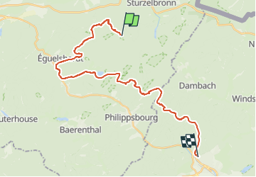
![](/images/other/stat-length.png)
![Trail On foot Sturzelbronn - Blue cross - Photo](https://media.geolcdn.com/t/1900/400/fff2d3ea-92b0-447d-8719-9088e8932805.jpeg&format=pjpeg&maxdim=2)
Blue cross
SityTrail - itinéraires balisés pédestres
Tous les sentiers balisés d’Europe GUIDE+
![Length](/images/other/stat-length.png)
![Max alt](https://static1.geolcdn.com/siteimages/upload/files/1508320355ic_sort_altitude_max_24dp.png)
![Uphill gradient](https://static1.geolcdn.com/siteimages/upload/files/1508320355ic_sort_den_pos_24dp.png)
![Km-Effort](/images/other/stat-length.png)
![Min alt](https://static1.geolcdn.com/siteimages/upload/files/1508320355ic_sort_altitude_min_24dp.png)
![Downhill gradient](https://static1.geolcdn.com/siteimages/upload/files/1508320355ic_sort_den_neg_24dp.png)
![Boucle](https://static1.geolcdn.com/siteimages/upload/files/16400158638029165_repeat_loop_refresh_sync_direction_icon.png)
![On foot](https://static1.geolcdn.com/sitytour/trail-icons/100.png)
8h29
Difficulty : Difficult
![Scan this QR Code to open this trail in the SityTrail application](https://capi.geolives.com/qq0zvz2zws4bq2lad0pu/sitytour/trails/3120780/qr.png?size=200)
FREE GPS app for hiking
About
Trail On foot of 27 km to be discovered at Grand Est, Moselle, Sturzelbronn. This trail is proposed by SityTrail - itinéraires balisés pédestres.
Description
Trail created by Club vosgien.
Symbol: blue cross
Website: https://ignrando.fr/fr/parcours/28082-3713et-bitche-20-croix-bleue-erbsenweiher-biesenberg-eguelshardt-hanau-falkenstein-molloch-col-riesthal-liese-les-acacias-niederbronn
Positioning
Comments
Trails nearby
![Trail Walking Éguelshardt - Notre Dame des Bois - Photo](https://media.geolcdn.com/t/375/260/3cf87b27-a59c-4ea6-a7bf-d652826f7266.jpg&format=jpg&maxdim=2)
![Walking Walking](https://static1.geolcdn.com/sitytour/trail-icons/101.png)
Walking
![](/images/other/stat-length.png)
![](https://static1.geolcdn.com/siteimages/upload/files/16400158638029165_repeat_loop_refresh_sync_direction_icon.png)
![Trail Walking Philippsbourg - Les 3 châteaux : Falkenstein, Rothenbourg, Waldeck - Photo](https://media.geolcdn.com/t/375/260/ext.jpg?maxdim=2&url=https%3A%2F%2Fservices.sitytrail.com%2FGeolivesWS%2FDownloadMedia.ashx%3FTrailID%3D118668%26Media%3D12831_5.jpg)
![Walking Walking](https://static1.geolcdn.com/sitytour/trail-icons/101.png)
Walking
![](/images/other/stat-length.png)
![](https://static1.geolcdn.com/siteimages/upload/files/16400158638029165_repeat_loop_refresh_sync_direction_icon.png)
![Trail On foot Sturzelbronn - Autour des moines de Sturzelbronn - Photo](https://media.geolcdn.com/t/375/260/caf7594f-14b2-48e2-8398-22008e31622f.jpeg&format=jpg&maxdim=2)
![On foot On foot](https://static1.geolcdn.com/sitytour/trail-icons/100.png)
On foot
![](/images/other/stat-length.png)
![](https://static1.geolcdn.com/siteimages/upload/files/16400158638029165_repeat_loop_refresh_sync_direction_icon.png)
![Trail On foot Sturzelbronn - Scenic cross-border trail No. 3 - Photo](https://media.geolcdn.com/t/375/260/9a7ba633-a867-49a1-a146-4bd2e867222a.jpeg&format=jpg&maxdim=2)
![On foot On foot](https://static1.geolcdn.com/sitytour/trail-icons/100.png)
On foot
![](/images/other/stat-length.png)
![](https://static1.geolcdn.com/siteimages/upload/files/16400158638029165_repeat_loop_refresh_sync_direction_icon.png)
![Trail On foot Philippsbourg - Blue dot - Photo](https://media.geolcdn.com/t/375/260/405334b8-fc9f-4697-8248-e0a1e7aa1239.jpeg&format=jpg&maxdim=2)
![On foot On foot](https://static1.geolcdn.com/sitytour/trail-icons/100.png)
![Trail On foot Philippsbourg - Yellow triangle - Photo](https://media.geolcdn.com/t/375/260/06ca872b-8d67-47d3-9a5d-7e9e4cc69f4c.jpeg&format=jpg&maxdim=2)
![On foot On foot](https://static1.geolcdn.com/sitytour/trail-icons/100.png)
On foot
![](/images/other/stat-length.png)
![](https://static1.geolcdn.com/siteimages/upload/files/16400158638029165_repeat_loop_refresh_sync_direction_icon.png)
![Trail On foot Philippsbourg - Blue triangle - Photo](https://media.geolcdn.com/t/375/260/7c4d1ef6-26c5-437b-8677-c479e1587290.jpeg&format=jpg&maxdim=2)
![On foot On foot](https://static1.geolcdn.com/sitytour/trail-icons/100.png)
On foot
![](/images/other/stat-length.png)
![](https://static1.geolcdn.com/siteimages/upload/files/16400158638029165_repeat_loop_refresh_sync_direction_icon.png)
![Trail On foot Baerenthal - Red ring - Photo](https://media.geolcdn.com/t/375/260/e09c10a5-8126-4ac4-b4b4-67480b4cfb80.jpeg&format=jpg&maxdim=2)
![On foot On foot](https://static1.geolcdn.com/sitytour/trail-icons/100.png)
![Trail On foot Baerenthal - Green ring - Photo](https://media.geolcdn.com/t/375/260/fb6c4c02-028c-4510-88f6-35680457b23b.jpeg&format=jpg&maxdim=2)
![On foot On foot](https://static1.geolcdn.com/sitytour/trail-icons/100.png)