![](/images/other/stat-length.png)
![Trail On foot Pula - Pantaleo-Is Cannoneris (202) - Photo](https://media.geolcdn.com/t/1900/400/ext.pjpeg?maxdim=2&url=https%3A%2F%2Fstatic1.geolcdn.com%2Fsiteimages%2Fupload%2Ffiles%2F1545311037marcheuse_200dpi.jpg)
Pantaleo-Is Cannoneris (202)
SityTrail - itinéraires balisés pédestres
Tous les sentiers balisés d’Europe GUIDE+
![Length](/images/other/stat-length.png)
Length
14 km
![Max alt](https://static1.geolcdn.com/siteimages/upload/files/1508320355ic_sort_altitude_max_24dp.png)
Max alt
834 m
![Uphill gradient](https://static1.geolcdn.com/siteimages/upload/files/1508320355ic_sort_den_pos_24dp.png)
Uphill gradient
577 m
![Km-Effort](/images/other/stat-length.png)
Km-Effort
24 km
![Min alt](https://static1.geolcdn.com/siteimages/upload/files/1508320355ic_sort_altitude_min_24dp.png)
Min alt
231 m
![Downhill gradient](https://static1.geolcdn.com/siteimages/upload/files/1508320355ic_sort_den_neg_24dp.png)
Downhill gradient
1159 m
![Boucle](https://static1.geolcdn.com/siteimages/upload/files/16400158638029165_repeat_loop_refresh_sync_direction_icon.png)
Boucle
No
Signpost
Creation date :
2022-02-15 15:11:23.804
Updated on :
2022-03-01 15:43:50.572
![On foot](https://static1.geolcdn.com/sitytour/trail-icons/100.png)
5h22
Difficulty : Medium
![Scan this QR Code to open this trail in the SityTrail application](https://capi.geolives.com/qq0zvz2zws4bq2lad0pu/sitytour/trails/3120738/qr.png?size=200)
FREE GPS app for hiking
About
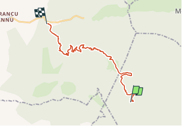
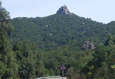
Trail On foot of 14 km to be discovered at Sardinia, Cagliari, Pula. This trail is proposed by SityTrail - itinéraires balisés pédestres.
Description
Trail created by Ente Foreste della Sardegna.
ATTENZIONE: PERCORSO IN MANUTENZIONE (alcuni tratti potrebbero risultare chiusi dalla vegetazione o percorribili con difficiltà).
Positioning
Country:
Italy
Region :
Sardinia
Department/Province :
Cagliari
Municipality :
Pula
Location:
Unknown
Start:(Dec)
Start:(UTM)
486977 ; 4322104 (32S) N.
Comments
Trails nearby
![Trail On foot Santadi - Pantaleo-Guardia is Murteras a S'arcu e' S'Arena (216) - Photo](https://media.geolcdn.com/t/375/260/1f994cce-6765-4660-a7fb-7b6583756990.jpeg&format=jpg&maxdim=2)
![On foot On foot](https://static1.geolcdn.com/sitytour/trail-icons/100.png)
Pantaleo-Guardia is Murteras a S'arcu e' S'Arena (216)
On foot
Easy
Santadi,
Sardinia,
Sud Sardegna,
Italy
![](/images/other/stat-length.png)
6.4 km | 12 km-effort
2h 42min
![](https://static1.geolcdn.com/siteimages/upload/files/16400158638029165_repeat_loop_refresh_sync_direction_icon.png)
No
![Trail On foot Santadi - Pantaleo – sorgente Is Arrus (215) - Photo](https://media.geolcdn.com/t/375/260/1f994cce-6765-4660-a7fb-7b6583756990.jpeg&format=jpg&maxdim=2)
![On foot On foot](https://static1.geolcdn.com/sitytour/trail-icons/100.png)
Pantaleo – sorgente Is Arrus (215)
On foot
Easy
Santadi,
Sardinia,
Sud Sardegna,
Italy
![](/images/other/stat-length.png)
5.2 km | 6.8 km-effort
1h 32min
![](https://static1.geolcdn.com/siteimages/upload/files/16400158638029165_repeat_loop_refresh_sync_direction_icon.png)
No
![Trail On foot Santadi - Monte Nieddu - Is Allineddus (210) - Photo](https://media.geolcdn.com/t/375/260/c6b9c93d-4452-4a04-b5b6-d0203d4043b0.jpeg&format=jpg&maxdim=2)
![On foot On foot](https://static1.geolcdn.com/sitytour/trail-icons/100.png)
Monte Nieddu - Is Allineddus (210)
On foot
Easy
Santadi,
Sardinia,
Sud Sardegna,
Italy
![](/images/other/stat-length.png)
8.7 km | 13.7 km-effort
3h 6min
![](https://static1.geolcdn.com/siteimages/upload/files/16400158638029165_repeat_loop_refresh_sync_direction_icon.png)
No
![Trail On foot Santadi - Tuppa Granella - Monte Nieddu (207) - Photo](https://media.geolcdn.com/t/375/260/c6b9c93d-4452-4a04-b5b6-d0203d4043b0.jpeg&format=jpg&maxdim=2)
![On foot On foot](https://static1.geolcdn.com/sitytour/trail-icons/100.png)
Tuppa Granella - Monte Nieddu (207)
On foot
Easy
Santadi,
Sardinia,
Sud Sardegna,
Italy
![](/images/other/stat-length.png)
12.2 km | 17.1 km-effort
3h 53min
![](https://static1.geolcdn.com/siteimages/upload/files/16400158638029165_repeat_loop_refresh_sync_direction_icon.png)
No
![Trail On foot Pula - Is Cannoneris-Monte Nieddu (201) - Photo](https://media.geolcdn.com/t/375/260/ext.jpg?maxdim=2&url=https%3A%2F%2Fstatic1.geolcdn.com%2Fsiteimages%2Fupload%2Ffiles%2F1545311037marcheuse_200dpi.jpg)
![On foot On foot](https://static1.geolcdn.com/sitytour/trail-icons/100.png)
Is Cannoneris-Monte Nieddu (201)
On foot
Medium
Pula,
Sardinia,
Cagliari,
Italy
![](/images/other/stat-length.png)
17.5 km | 25 km-effort
5h 40min
![](https://static1.geolcdn.com/siteimages/upload/files/16400158638029165_repeat_loop_refresh_sync_direction_icon.png)
No
![Trail On foot Pula - Is Cannoneris-Sa Galanza (212) - Photo](https://media.geolcdn.com/t/375/260/ext.jpg?maxdim=2&url=https%3A%2F%2Fstatic1.geolcdn.com%2Fsiteimages%2Fupload%2Ffiles%2F1545311037marcheuse_200dpi.jpg)
![On foot On foot](https://static1.geolcdn.com/sitytour/trail-icons/100.png)
Is Cannoneris-Sa Galanza (212)
On foot
Medium
Pula,
Sardinia,
Cagliari,
Italy
![](/images/other/stat-length.png)
19.6 km | 29 km-effort
6h 29min
![](https://static1.geolcdn.com/siteimages/upload/files/16400158638029165_repeat_loop_refresh_sync_direction_icon.png)
No