![](/images/other/stat-length.png)
![Trail On foot Collazzone - Collepepe-Miniera - Photo](https://media.geolcdn.com/t/1900/400/824624c1-d83b-493b-8602-8159e0ff647f.jpeg&format=pjpeg&maxdim=2)
Collepepe-Miniera
SityTrail - itinéraires balisés pédestres
Tous les sentiers balisés d’Europe GUIDE+
![Length](/images/other/stat-length.png)
Length
7.3 km
![Max alt](https://static1.geolcdn.com/siteimages/upload/files/1508320355ic_sort_altitude_max_24dp.png)
Max alt
350 m
![Uphill gradient](https://static1.geolcdn.com/siteimages/upload/files/1508320355ic_sort_den_pos_24dp.png)
Uphill gradient
226 m
![Km-Effort](/images/other/stat-length.png)
Km-Effort
10.4 km
![Min alt](https://static1.geolcdn.com/siteimages/upload/files/1508320355ic_sort_altitude_min_24dp.png)
Min alt
168 m
![Downhill gradient](https://static1.geolcdn.com/siteimages/upload/files/1508320355ic_sort_den_neg_24dp.png)
Downhill gradient
246 m
![Boucle](https://static1.geolcdn.com/siteimages/upload/files/16400158638029165_repeat_loop_refresh_sync_direction_icon.png)
Boucle
No
Signpost
Creation date :
2022-02-15 14:34:18.563
Updated on :
2022-03-01 14:41:24.225
![On foot](https://static1.geolcdn.com/sitytour/trail-icons/100.png)
2h21
Difficulty : Easy
![Scan this QR Code to open this trail in the SityTrail application](https://capi.geolives.com/qq0zvz2zws4bq2lad0pu/sitytour/trails/3120046/qr.png?size=200)
FREE GPS app for hiking
About
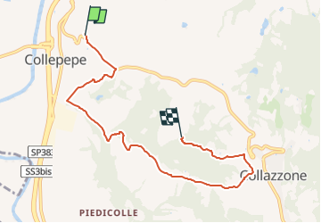
Trail On foot of 7.3 km to be discovered at Umbria, Perugia, Collazzone. This trail is proposed by SityTrail - itinéraires balisés pédestres.
Description
Trail created by Comune di Collazzone.
number of itinerary being updated Umbria Excursion Network
Symbol: 930 on white red flag
Website: http://www.comune.collazzone.pg.it/index.php/sentieri-naturalistici
Positioning
Country:
Italy
Region :
Umbria
Department/Province :
Perugia
Municipality :
Collazzone
Location:
Unknown
Start:(Dec)
Start:(UTM)
287717 ; 4755251 (33T) N.
Comments
Trails nearby
![Trail On foot Collazzone - Anello di Collazzone - Photo](https://media.geolcdn.com/t/375/260/bc74a1a8-86f5-42e2-a1b6-d8597857bdbf.jpeg&format=jpg&maxdim=2)
![On foot On foot](https://static1.geolcdn.com/sitytour/trail-icons/100.png)
Anello di Collazzone
On foot
Medium
Collazzone,
Umbria,
Perugia,
Italy
![](/images/other/stat-length.png)
15.8 km | 25 km-effort
5h 41min
![](https://static1.geolcdn.com/siteimages/upload/files/16400158638029165_repeat_loop_refresh_sync_direction_icon.png)
Yes
![Trail On foot Collazzone - Collazzone-Molino delle Botte - Photo](https://media.geolcdn.com/t/375/260/4cf1d3cb-f0bc-4d1f-872a-c0201a927ae8.jpeg&format=jpg&maxdim=2)
![On foot On foot](https://static1.geolcdn.com/sitytour/trail-icons/100.png)
Collazzone-Molino delle Botte
On foot
Easy
Collazzone,
Umbria,
Perugia,
Italy
![](/images/other/stat-length.png)
8.1 km | 13 km-effort
2h 56min
![](https://static1.geolcdn.com/siteimages/upload/files/16400158638029165_repeat_loop_refresh_sync_direction_icon.png)
Yes
![Trail On foot Deruta - Castelleone - Perugia Vecchia - Photo](https://media.geolcdn.com/t/375/260/ext.jpg?maxdim=2&url=https%3A%2F%2Fstatic1.geolcdn.com%2Fsiteimages%2Fupload%2Ffiles%2F1545311037marcheuse_200dpi.jpg)
![On foot On foot](https://static1.geolcdn.com/sitytour/trail-icons/100.png)
Castelleone - Perugia Vecchia
On foot
Easy
Deruta,
Umbria,
Perugia,
Italy
![](/images/other/stat-length.png)
9.6 km | 14.2 km-effort
3h 13min
![](https://static1.geolcdn.com/siteimages/upload/files/16400158638029165_repeat_loop_refresh_sync_direction_icon.png)
Yes