![](/images/other/stat-length.png)
![Trail On foot Anglards-de-Salers - Anglards de Salers - Photo](https://media.geolcdn.com/t/1900/400/ext.pjpeg?maxdim=2&url=https%3A%2F%2Fstatic1.geolcdn.com%2Fsiteimages%2Fupload%2Ffiles%2F1545311037marcheuse_200dpi.jpg)
Anglards de Salers
SityTrail - itinéraires balisés pédestres
Tous les sentiers balisés d’Europe GUIDE+
![Length](/images/other/stat-length.png)
Length
3.6 km
![Max alt](https://static1.geolcdn.com/siteimages/upload/files/1508320355ic_sort_altitude_max_24dp.png)
Max alt
861 m
![Uphill gradient](https://static1.geolcdn.com/siteimages/upload/files/1508320355ic_sort_den_pos_24dp.png)
Uphill gradient
53 m
![Km-Effort](/images/other/stat-length.png)
Km-Effort
4.3 km
![Min alt](https://static1.geolcdn.com/siteimages/upload/files/1508320355ic_sort_altitude_min_24dp.png)
Min alt
808 m
![Downhill gradient](https://static1.geolcdn.com/siteimages/upload/files/1508320355ic_sort_den_neg_24dp.png)
Downhill gradient
50 m
![Boucle](https://static1.geolcdn.com/siteimages/upload/files/16400158638029165_repeat_loop_refresh_sync_direction_icon.png)
Boucle
Yes
Signpost
Creation date :
2022-02-15 14:26:10.775
Updated on :
2022-03-02 16:04:33.6
![On foot](https://static1.geolcdn.com/sitytour/trail-icons/100.png)
58m
Difficulty : Easy
![Scan this QR Code to open this trail in the SityTrail application](https://capi.geolives.com/qq0zvz2zws4bq2lad0pu/sitytour/trails/3119877/qr.png?size=200)
FREE GPS app for hiking
About
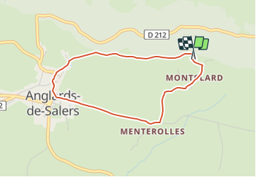
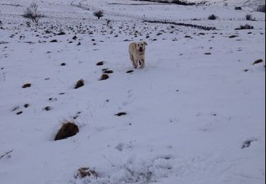
Trail On foot of 3.6 km to be discovered at Auvergne-Rhône-Alpes, Cantal, Anglards-de-Salers. This trail is proposed by SityTrail - itinéraires balisés pédestres.
Description
Trail created by Pays de Salers.
Symbol: bleu
Positioning
Country:
France
Region :
Auvergne-Rhône-Alpes
Department/Province :
Cantal
Municipality :
Anglards-de-Salers
Location:
Unknown
Start:(Dec)
Start:(UTM)
457347 ; 5006116 (31T) N.
Comments
Trails nearby
![Trail On foot Anglards-de-Salers - Sur la route des transhumances - Photo](https://media.geolcdn.com/t/375/260/aee6fb60-5794-4edc-9366-95f26f44ce67.jpeg&format=jpg&maxdim=2)
![On foot On foot](https://static1.geolcdn.com/sitytour/trail-icons/100.png)
Sur la route des transhumances
On foot
Medium
Anglards-de-Salers,
Auvergne-Rhône-Alpes,
Cantal,
France
![](/images/other/stat-length.png)
19.1 km | 27 km-effort
6h 11min
![](https://static1.geolcdn.com/siteimages/upload/files/16400158638029165_repeat_loop_refresh_sync_direction_icon.png)
No
![Trail On foot Anglards-de-Salers - Sur la route des transhumances étape 1 - Photo](https://media.geolcdn.com/t/375/260/aee6fb60-5794-4edc-9366-95f26f44ce67.jpeg&format=jpg&maxdim=2)
![On foot On foot](https://static1.geolcdn.com/sitytour/trail-icons/100.png)
Sur la route des transhumances étape 1
On foot
Medium
Anglards-de-Salers,
Auvergne-Rhône-Alpes,
Cantal,
France
![](/images/other/stat-length.png)
21 km | 30 km-effort
6h 42min
![](https://static1.geolcdn.com/siteimages/upload/files/16400158638029165_repeat_loop_refresh_sync_direction_icon.png)
No
![Trail Cycle Anglards-de-Salers - falgoux - Photo](https://media.geolcdn.com/t/375/260/ext.jpg?maxdim=2&url=https%3A%2F%2Fstatic1.geolcdn.com%2Fsiteimages%2Fupload%2Ffiles%2F1524743154velo.jpg)
![Cycle Cycle](https://static1.geolcdn.com/sitytour/trail-icons/200.png)
falgoux
Cycle
Very easy
(1)
Anglards-de-Salers,
Auvergne-Rhône-Alpes,
Cantal,
France
![](/images/other/stat-length.png)
50 km | 66 km-effort
2h 39min
![](https://static1.geolcdn.com/siteimages/upload/files/16400158638029165_repeat_loop_refresh_sync_direction_icon.png)
Yes
![Trail Walking Anglards-de-Salers - chemin des estives - Photo](https://media.geolcdn.com/t/375/260/57218aee-b8a5-4272-ade5-c9167cc7afcf.jpg&format=jpg&maxdim=2)
![Walking Walking](https://static1.geolcdn.com/sitytour/trail-icons/101.png)
chemin des estives
Walking
Very difficult
Anglards-de-Salers,
Auvergne-Rhône-Alpes,
Cantal,
France
![](/images/other/stat-length.png)
14.9 km | 19.4 km-effort
3h 6min
![](https://static1.geolcdn.com/siteimages/upload/files/16400158638029165_repeat_loop_refresh_sync_direction_icon.png)
No
![Trail Walking Anglards-de-Salers - Chemin des estives - Photo](https://media.geolcdn.com/t/375/260/8109f75b-fa3c-472c-95da-892e60f4c12d.jpg&format=jpg&maxdim=2)
![Walking Walking](https://static1.geolcdn.com/sitytour/trail-icons/101.png)
Chemin des estives
Walking
Very easy
Anglards-de-Salers,
Auvergne-Rhône-Alpes,
Cantal,
France
![](/images/other/stat-length.png)
9.2 km | 11.5 km-effort
2h 32min
![](https://static1.geolcdn.com/siteimages/upload/files/16400158638029165_repeat_loop_refresh_sync_direction_icon.png)
No
![Trail On foot Anglards-de-Salers - Promenade des estives - Photo](https://media.geolcdn.com/t/375/260/ext.jpg?maxdim=2&url=https%3A%2F%2Fstatic1.geolcdn.com%2Fsiteimages%2Fupload%2Ffiles%2F1545311037marcheuse_200dpi.jpg)
![On foot On foot](https://static1.geolcdn.com/sitytour/trail-icons/100.png)
Promenade des estives
On foot
Easy
Anglards-de-Salers,
Auvergne-Rhône-Alpes,
Cantal,
France
![](/images/other/stat-length.png)
4.7 km | 6.4 km-effort
1h 27min
![](https://static1.geolcdn.com/siteimages/upload/files/16400158638029165_repeat_loop_refresh_sync_direction_icon.png)
No
![Trail On foot Anglards-de-Salers - Anglards-de-Salers - Photo](https://media.geolcdn.com/t/375/260/ext.jpg?maxdim=2&url=https%3A%2F%2Fstatic1.geolcdn.com%2Fsiteimages%2Fupload%2Ffiles%2F1545311037marcheuse_200dpi.jpg)
![On foot On foot](https://static1.geolcdn.com/sitytour/trail-icons/100.png)
Anglards-de-Salers
On foot
Easy
Anglards-de-Salers,
Auvergne-Rhône-Alpes,
Cantal,
France
![](/images/other/stat-length.png)
3.6 km | 4.3 km-effort
58min
![](https://static1.geolcdn.com/siteimages/upload/files/16400158638029165_repeat_loop_refresh_sync_direction_icon.png)
Yes
![Trail Other activity Anglards-de-Salers - anglards fevrier2014 - Photo](https://media.geolcdn.com/t/375/260/ext.jpg?maxdim=2&url=https%3A%2F%2Fservices.sitytrail.com%2FGeolivesWS%2FDownloadMedia.ashx%3FTrailID%3D252721%26Media%3D20140226160941.jpg)
![Other activity Other activity](https://static1.geolcdn.com/sitytour/trail-icons/900.png)
anglards fevrier2014
Other activity
Very easy
Anglards-de-Salers,
Auvergne-Rhône-Alpes,
Cantal,
France
![](/images/other/stat-length.png)
8.3 km | 10.5 km-effort
2h 12min
![](https://static1.geolcdn.com/siteimages/upload/files/16400158638029165_repeat_loop_refresh_sync_direction_icon.png)
Yes
![Trail Walking Anglards-de-Salers - les Aldieres- Bacheluze - Photo](https://media.geolcdn.com/t/375/260/ext.jpg?maxdim=2&url=https%3A%2F%2Fstatic1.geolcdn.com%2Fsiteimages%2Fupload%2Ffiles%2F1553511878bg_sport_marche.png)
![Walking Walking](https://static1.geolcdn.com/sitytour/trail-icons/101.png)
les Aldieres- Bacheluze
Walking
Medium
Anglards-de-Salers,
Auvergne-Rhône-Alpes,
Cantal,
France
![](/images/other/stat-length.png)
5.8 km | 9.7 km-effort
2h 9min
![](https://static1.geolcdn.com/siteimages/upload/files/16400158638029165_repeat_loop_refresh_sync_direction_icon.png)
Yes