Trail On foot Gardone Riviera - Sentiero Cristoforo Campanardi - Photo

Sentiero Cristoforo Campanardi

Tous les sentiers balisés d’Europe GUIDE+

© OpenStreetMap contributors
Length
Length
4.2 km
Max alt
Max alt
806 m
Uphill gradient
Uphill gradient
9 m
Km-Effort
Km-Effort  
6.1 km
Min alt
Min alt
256 m
Downhill gradient
Downhill gradient
553 m
Boucle
Boucle
No
Signpost
Signpost
Creation date :
2022-02-15 14:25:15.997
Updated on :
2022-03-01 14:15:44.516

(0 Reviews)

On foot
On foot
1h23
Difficulty : Easy

Scan this QR Code to open this trail in the SityTrail application

FREE GPS app for hiking

Logo SityTrail SityTrail

IGN / Geographical institutes

Download SityTrail from the App Store Download SityTrail from Google Play

Logo SityTrail SityTrail World

The world is yours!

Download SityTrail from the App Store Download SityTrail from Google Play Download SityTrail on Huawei AppGallery

About

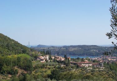
Trail On foot of 4.2 km to be discovered at Lombardy, Brescia, Gardone Riviera. This trail is proposed by SityTrail - itinéraires balisés pédestres.

Description

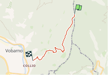
Trail created by A.N.P.I. sez. di Vobarno.

Symbol: blue flag with yellow writing ANPI

Elevation profile

Positioning

Country:
Italy
Region :
Lombardy
Department/Province :
Brescia
Municipality :
Gardone Riviera
Location:
Unknown
Start:(UTM)
619527 ; 5057213 (32T) N.

Trails nearby

Trail On foot Salò - Gardone Riviera (Barbarano) - Passo Spino - Photo
On foot
GUIDE+

On foot

Medium
Salò, Lombardy, Brescia, Italy
10.5 km | 22 km-effort
4h 58min
No
Trail On foot Gardone Riviera - San Michele - Colomber, Passo Spino, Rifugio G. Pirlo - Photo
On foot
GUIDE+

On foot

Easy
Gardone Riviera, Lombardy, Brescia, Italy
6.1 km | 13.8 km-effort
3h 8min
No
Trail On foot Gardone Riviera - Supiane (BVG), passo del Buelino, San Michele - Photo
On foot
GUIDE+

On foot

Easy
Gardone Riviera, Lombardy, Brescia, Italy
5.9 km | 11.8 km-effort
2h 40min
No
Trail On foot Gardone Riviera - San Michele - Gaino - Photo
On foot
GUIDE+

On foot

Easy
Gardone Riviera, Lombardy, Brescia, Italy
10.1 km | 15.6 km-effort
3h 32min
No
Trail On foot Vobarno - IT-500 - Photo
On foot
GUIDE+

On foot

Easy
Vobarno, Lombardy, Brescia, Italy
7.2 km | 13.8 km-effort
3h 7min
No
Trail On foot Roè Volciano - Renzano - Passo della Stacca - Photo
On foot
GUIDE+

On foot

Easy
Roè Volciano, Lombardy, Brescia, Italy
3.4 km | 6.7 km-effort
1h 31min
No
Trail On foot Roè Volciano - Percorso delle Chiese - Roè Volciano - Photo
On foot
GUIDE+

On foot

Easy
Roè Volciano, Lombardy, Brescia, Italy
4.6 km | 6.9 km-effort
1h 33min
No
Trail On foot Toscolano Maderno - Cresta sud Pizzocolo - Photo
On foot
GUIDE+

On foot

Easy
Toscolano Maderno, Lombardy, Brescia, Italy
3.5 km | 12.2 km-effort
2h 46min
No
Trail On foot Toscolano Maderno - Magnico - Sant'Urbano - Doss de le Prade - Photo
On foot
GUIDE+

On foot

Easy
Toscolano Maderno, Lombardy, Brescia, Italy
6.4 km | 10.1 km-effort
2h 17min
No


Close
My subscriptions