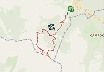
![](/images/other/stat-length.png)
![Trail On foot Minucciano - Sentiero dei meno mille - Photo](https://media.geolcdn.com/t/1900/400/ext.pjpeg?maxdim=2&url=https%3A%2F%2Fstatic1.geolcdn.com%2Fsiteimages%2Fupload%2Ffiles%2F1545311037marcheuse_200dpi.jpg)
Sentiero dei meno mille
SityTrail - itinéraires balisés pédestres
Tous les sentiers balisés d’Europe PRO
![Length](/images/other/stat-length.png)
Length
6.9 km
![Max alt](https://static1.geolcdn.com/siteimages/upload/files/1508320355ic_sort_altitude_max_24dp.png)
Max alt
1730 m
![Uphill gradient](https://static1.geolcdn.com/siteimages/upload/files/1508320355ic_sort_den_pos_24dp.png)
Uphill gradient
721 m
![Km-Effort](/images/other/stat-length.png)
Km-Effort
15.8 km
![Min alt](https://static1.geolcdn.com/siteimages/upload/files/1508320355ic_sort_altitude_min_24dp.png)
Min alt
1006 m
![Downhill gradient](https://static1.geolcdn.com/siteimages/upload/files/1508320355ic_sort_den_neg_24dp.png)
Downhill gradient
510 m
![Boucle](https://static1.geolcdn.com/siteimages/upload/files/16400158638029165_repeat_loop_refresh_sync_direction_icon.png)
Boucle
No
Signpost
Creation date :
2022-02-15 14:19:42.879
Updated on :
2022-03-01 14:06:08.092
![On foot](https://static1.geolcdn.com/sitytour/trail-icons/100.png)
3h35
Difficulty : Easy
![Scan this QR Code to open this trail in the SityTrail application](https://capi.geolives.com/qq0zvz2zws4bq2lad0pu/sitytour/trails/3119786/qr.png?size=200)
FREE GPS app for hiking
About
Trail On foot of 6.9 km to be discovered at Tuscany, Lucca, Minucciano. This trail is proposed by SityTrail - itinéraires balisés pédestres.
Description
Trail created by Gruppo Speleologico Fiorentino CAI – Speleoclub Garfagnana CAI – Unione Speleologica Pratese.
Website: https://www.sentieromenomille.it/it/
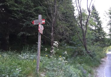
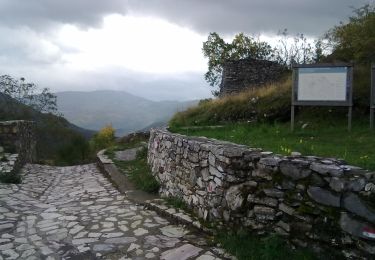
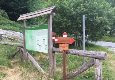
Positioning
Country:
Italy
Region :
Tuscany
Department/Province :
Lucca
Municipality :
Minucciano
Location:
Unknown
Start:(Dec)
Start:(UTM)
598909 ; 4886995 (32T) N.
Comments
Trails nearby
![Trail On foot Minucciano - IT-37 - Photo](https://media.geolcdn.com/t/375/260/ext.jpg?maxdim=2&url=https%3A%2F%2Fmedia.geolcdn.com%2Ff%2F55dcc5c5-cff9-49fc-9beb-705f8ddff19f.jpeg)
![On foot On foot](https://static1.geolcdn.com/sitytour/trail-icons/100.png)
![Trail On foot Vagli Sotto - IT-177 - Photo](https://media.geolcdn.com/t/375/260/ext.jpg?maxdim=2&url=https%3A%2F%2Fmedia.geolcdn.com%2Ff%2F4f02ead0-fce7-44ec-9b61-cb976b45530f.jpeg)
![On foot On foot](https://static1.geolcdn.com/sitytour/trail-icons/100.png)
![Trail On foot Minucciano - Sentiero attrezzato](https://media.geolcdn.com/t/375/260/ext.jpg?maxdim=2&url=https%3A%2F%2Fmedia.geolcdn.com%2Ff%2F0879e73d-4fe0-4994-a604-1d66de009c75.jpeg)
![On foot On foot](https://static1.geolcdn.com/sitytour/trail-icons/100.png)
Sentiero attrezzato "Mario Piotti"
On foot
Easy
Minucciano,
Tuscany,
Lucca,
Italy
![](/images/other/stat-length.png)
3.1 km | 6.8 km-effort
1h 33min
![](https://static1.geolcdn.com/siteimages/upload/files/16400158638029165_repeat_loop_refresh_sync_direction_icon.png)
No
![Trail On foot Casola in Lunigiana - IT-181 - Photo](https://media.geolcdn.com/t/375/260/ext.jpg?maxdim=2&url=https%3A%2F%2Fmedia.geolcdn.com%2Ff%2F0879e73d-4fe0-4994-a604-1d66de009c75.jpeg)
![On foot On foot](https://static1.geolcdn.com/sitytour/trail-icons/100.png)
IT-181
On foot
Easy
Casola in Lunigiana,
Tuscany,
Massa-Carrara,
Italy
![](/images/other/stat-length.png)
5.2 km | 13.4 km-effort
3h 3min
![](https://static1.geolcdn.com/siteimages/upload/files/16400158638029165_repeat_loop_refresh_sync_direction_icon.png)
No
![Trail On foot Minucciano - IT-179 - Photo](https://media.geolcdn.com/t/375/260/ext.jpg?maxdim=2&url=https%3A%2F%2Fmedia.geolcdn.com%2Ff%2Ffbcbd227-8b0b-4609-bec1-44c21ea0b4c8.jpeg)
![On foot On foot](https://static1.geolcdn.com/sitytour/trail-icons/100.png)
![Trail On foot Massa - Via Vandelli - Photo](https://media.geolcdn.com/t/375/260/ext.jpg?maxdim=2&url=https%3A%2F%2Fmedia.geolcdn.com%2Ff%2Ff3d89b01-31a5-4341-b9c1-6c956f0e4a4d.jpeg)
![On foot On foot](https://static1.geolcdn.com/sitytour/trail-icons/100.png)
![Trail On foot Minucciano - Garfagnana Trekking - Tappa 5 - Photo](https://media.geolcdn.com/t/375/260/ext.jpg?maxdim=2&url=https%3A%2F%2Fmedia.geolcdn.com%2Ff%2Fe32f080c-3022-4451-ba14-d58f20b248de.jpeg)
![On foot On foot](https://static1.geolcdn.com/sitytour/trail-icons/100.png)
Garfagnana Trekking - Tappa 5
On foot
Medium
Minucciano,
Tuscany,
Lucca,
Italy
![](/images/other/stat-length.png)
15.5 km | 22 km-effort
5h 2min
![](https://static1.geolcdn.com/siteimages/upload/files/16400158638029165_repeat_loop_refresh_sync_direction_icon.png)
No
![Trail On foot Vagli Sotto - Garfagnana Trekking - Tappa 4 - Photo](https://media.geolcdn.com/t/375/260/ext.jpg?maxdim=2&url=https%3A%2F%2Fmedia.geolcdn.com%2Ff%2F8a76feed-628b-4640-b6ee-ada0c7fb7030.jpeg)
![On foot On foot](https://static1.geolcdn.com/sitytour/trail-icons/100.png)
Garfagnana Trekking - Tappa 4
On foot
Medium
Vagli Sotto,
Tuscany,
Lucca,
Italy
![](/images/other/stat-length.png)
10.1 km | 23 km-effort
5h 10min
![](https://static1.geolcdn.com/siteimages/upload/files/16400158638029165_repeat_loop_refresh_sync_direction_icon.png)
No
![Trail On foot Vagli Sotto - Garfagnana Trekking - Tappa 3 - Photo](https://media.geolcdn.com/t/375/260/ext.jpg?maxdim=2&url=https%3A%2F%2Fmedia.geolcdn.com%2Ff%2F928de389-9e7d-43b3-8486-3586737a4282.jpeg)
![On foot On foot](https://static1.geolcdn.com/sitytour/trail-icons/100.png)
Garfagnana Trekking - Tappa 3
On foot
Medium
Vagli Sotto,
Tuscany,
Lucca,
Italy
![](/images/other/stat-length.png)
16.1 km | 27 km-effort
6h 8min
![](https://static1.geolcdn.com/siteimages/upload/files/16400158638029165_repeat_loop_refresh_sync_direction_icon.png)
No