Trail On foot Fénis - Veulla - Colle Medzove - Photo

Veulla - Colle Medzove

Tous les sentiers balisés d’Europe PRO

© OpenStreetMap contributors
Length
Length
12.5 km
Max alt
Max alt
2616 m
Uphill gradient
Uphill gradient
69 m
Km-Effort
Km-Effort  
17.8 km
Min alt
Min alt
1292 m
Downhill gradient
Downhill gradient
1390 m
Boucle
Boucle
No
Signpost
Signpost
Creation date :
2022-02-15 09:44:17.525
Updated on :
2022-03-01 07:13:15.008

(0 Reviews)

On foot
On foot
4h03
Difficulty : Easy

Scan this QR Code to open this trail in the SityTrail application

FREE GPS app for hiking

Logo SityTrail SityTrail

IGN / Geographical institutes

Download SityTrail from the App Store Download SityTrail from Google Play

Logo SityTrail SityTrail World

The world is yours!

Download SityTrail from the App Store Download SityTrail from Google Play Download SityTrail on Huawei AppGallery

About

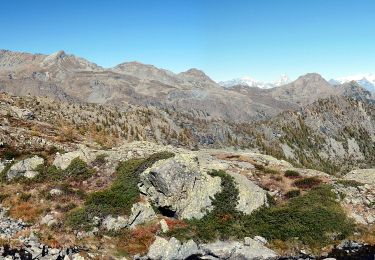
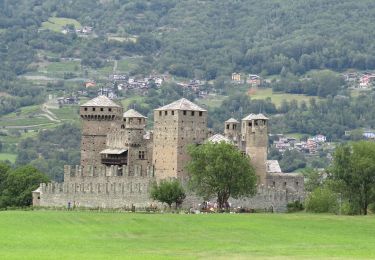
Trail On foot of 12.5 km to be discovered at Aosta Valley, Unknown, Fénis. This trail is proposed by SityTrail - itinéraires balisés pédestres.

Description

Symbol: 5C on yellow dot in black circle, or yellow line

Photos

Positioning

Country:
Italy
Region :
Aosta Valley
Department/Province :
Unknown
Municipality :
Fénis
Location:
Unknown
Start:(UTM)
386448 ; 5055181 (32T) N.

Trails nearby

Trail On foot Champorcher - Alta Via n. 2 della Valle d'Aosta - Tappa 12 - Photo
On foot
PRO

On foot

Easy
Champorcher, Aosta Valley, Unknown, Italy
8.8 km | 11.9 km-effort
2h 42min
No
Trail On foot Fénis - Itinerario 4 Clavalité Col de Mezove - Photo
On foot
PRO

On foot

Easy
Fénis, Aosta Valley, Unknown, Italy
4.8 km | 7.4 km-effort
1h 41min
No
Trail On foot Cogne - Alta Via n. 2 della Valle d'Aosta - Tappa 11 - Photo
On foot
PRO

On foot

Easy
Cogne, Aosta Valley, Unknown, Italy
7.5 km | 12.5 km-effort
2h 50min
No
Trail On foot Champorcher - Sentiero 5C - Cuneu-Col Fussy - Photo
On foot
PRO

On foot

Easy
Champorcher, Aosta Valley, Unknown, Italy
3.2 km | 5.7 km-effort
1h 18min
No
Trail On foot Champdepraz - Sentiero Ru de Chevrère et Montjovet - Photo
On foot
PRO

On foot

Easy
Champdepraz, Aosta Valley, Unknown, Italy
5.6 km | 7.3 km-effort
1h 40min
No
Trail On foot Fénis - Sentiero 6 - GrandAlpe-Col Fenis - Photo
On foot
PRO

On foot

Easy
Fénis, Aosta Valley, Unknown, Italy
3.5 km | 10.6 km-effort
2h 24min
No
Trail On foot Fénis - Sentiero 5 - Etzely-Col de LìEtzely - Photo
On foot
PRO

On foot

Medium
Fénis, Aosta Valley, Unknown, Italy
9.5 km | 22 km-effort
4h 53min
No
Trail On foot Fénis - Sentiero 8 - Maisonasse(1.545)-Chardonney-Praz Premier(2.036) - EE - 3h00' - disl. 865 - Photo
On foot
PRO

On foot

Easy
Fénis, Aosta Valley, Unknown, Italy
4.8 km | 13.4 km-effort
3h 2min
No
Trail Walking Champorcher - Alta via val d’Aoste2 etape8 (Champorcher-Crest) - Photo
Walking
philvidal

Walking

Very difficult
Champorcher, Aosta Valley, Unknown, Italy
18.7 km | 39 km-effort
6h 9min
No


Close
My subscriptions