![](/images/other/stat-length.png)
![Trail Other activity Quincampoix - un chemin une école. Quincampoix 10-06-14 - Photo](https://media.geolcdn.com/t/1900/400/ext.pjpeg?maxdim=2&url=https%3A%2F%2Fstatic1.geolcdn.com%2Fsiteimages%2Fupload%2Ffiles%2F1545311037marcheuse_200dpi.jpg)
un chemin une école. Quincampoix 10-06-14
haddock
User
![Length](/images/other/stat-length.png)
Length
11.8 km
![Max alt](https://static1.geolcdn.com/siteimages/upload/files/1508320355ic_sort_altitude_max_24dp.png)
Max alt
182 m
![Uphill gradient](https://static1.geolcdn.com/siteimages/upload/files/1508320355ic_sort_den_pos_24dp.png)
Uphill gradient
94 m
![Km-Effort](/images/other/stat-length.png)
Km-Effort
13.1 km
![Min alt](https://static1.geolcdn.com/siteimages/upload/files/1508320355ic_sort_altitude_min_24dp.png)
Min alt
142 m
![Downhill gradient](https://static1.geolcdn.com/siteimages/upload/files/1508320355ic_sort_den_neg_24dp.png)
Downhill gradient
95 m
![Boucle](https://static1.geolcdn.com/siteimages/upload/files/16400158638029165_repeat_loop_refresh_sync_direction_icon.png)
Boucle
Yes
Creation date :
2014-12-10 00:00:00.0
Updated on :
2014-12-10 00:00:00.0
![Other activity](https://static1.geolcdn.com/sitytour/trail-icons/900.png)
4h50
Difficulty : Easy
![Scan this QR Code to open this trail in the SityTrail application](https://capi.geolives.com/qq0zvz2zws4bq2lad0pu/sitytour/trails/311718/qr.png?size=200)
FREE GPS app for hiking
About
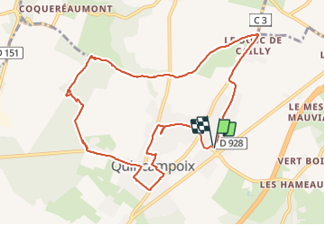
Trail Other activity of 11.8 km to be discovered at Normandy, Seine-Maritime, Quincampoix. This trail is proposed by haddock.
Description
distance réelle effectuée 11km (allers retours mare au loup à déduire 800m environ)
durée 290 mn en tout(à déduire temps pauses, repas,explications carte, boussole etc...)
Positioning
Country:
France
Region :
Normandy
Department/Province :
Seine-Maritime
Municipality :
Quincampoix
Location:
Unknown
Start:(Dec)
Start:(UTM)
368743 ; 5487203 (31U) N.
Comments
Trails nearby
![Trail Walking Quincampoix - 076-29-Quincampoix 10km -496-626 - Photo](https://media.geolcdn.com/t/375/260/77288098-4062-4eec-991a-4ccce3a169cf.jpg&format=jpg&maxdim=2)
![Walking Walking](https://static1.geolcdn.com/sitytour/trail-icons/101.png)
076-29-Quincampoix 10km -496-626
Walking
Easy
(1)
Quincampoix,
Normandy,
Seine-Maritime,
France
![](/images/other/stat-length.png)
9.9 km | 11.2 km-effort
2h 28min
![](https://static1.geolcdn.com/siteimages/upload/files/16400158638029165_repeat_loop_refresh_sync_direction_icon.png)
Yes
![Walking Walking](https://static1.geolcdn.com/sitytour/trail-icons/101.png)
20240504-Le Grand Tendos
Walking
Medium
Fontaine-le-Bourg,
Normandy,
Seine-Maritime,
France
![](/images/other/stat-length.png)
12.9 km | 16.3 km-effort
3h 50min
![](https://static1.geolcdn.com/siteimages/upload/files/16400158638029165_repeat_loop_refresh_sync_direction_icon.png)
Yes
![Walking Walking](https://static1.geolcdn.com/sitytour/trail-icons/101.png)
20240120-Preaux
Walking
Difficult
(1)
Préaux,
Normandy,
Seine-Maritime,
France
![](/images/other/stat-length.png)
12.7 km | 13.8 km-effort
3h 8min
![](https://static1.geolcdn.com/siteimages/upload/files/16400158638029165_repeat_loop_refresh_sync_direction_icon.png)
Yes
![Walking Walking](https://static1.geolcdn.com/sitytour/trail-icons/101.png)
20231123-St Geotges sur Fontaine
Walking
Medium
Saint-Georges-sur-Fontaine,
Normandy,
Seine-Maritime,
France
![](/images/other/stat-length.png)
11 km | 12.8 km-effort
3h 4min
![](https://static1.geolcdn.com/siteimages/upload/files/16400158638029165_repeat_loop_refresh_sync_direction_icon.png)
Yes
![Walking Walking](https://static1.geolcdn.com/sitytour/trail-icons/101.png)
20221015-St Geirges sur Fontaine
Walking
Medium
Saint-Georges-sur-Fontaine,
Normandy,
Seine-Maritime,
France
![](/images/other/stat-length.png)
11.1 km | 12.9 km-effort
3h 3min
![](https://static1.geolcdn.com/siteimages/upload/files/16400158638029165_repeat_loop_refresh_sync_direction_icon.png)
Yes
![Walking Walking](https://static1.geolcdn.com/sitytour/trail-icons/101.png)
20210817-Preaux
Walking
Medium
Préaux,
Normandy,
Seine-Maritime,
France
![](/images/other/stat-length.png)
13 km | 16.2 km-effort
3h 42min
![](https://static1.geolcdn.com/siteimages/upload/files/16400158638029165_repeat_loop_refresh_sync_direction_icon.png)
Yes
![Walking Walking](https://static1.geolcdn.com/sitytour/trail-icons/101.png)
20210805-fontaine-le-bourg
Walking
Very easy
Fontaine-le-Bourg,
Normandy,
Seine-Maritime,
France
![](/images/other/stat-length.png)
21 km | 26 km-effort
Unknown
![](https://static1.geolcdn.com/siteimages/upload/files/16400158638029165_repeat_loop_refresh_sync_direction_icon.png)
Yes
![Trail Walking Saint-Georges-sur-Fontaine - 20150207 St Georges sur fontaine - Photo](https://media.geolcdn.com/t/375/260/ext.jpg?maxdim=2&url=https%3A%2F%2Fservices.sitytrail.com%2FGeolivesWS%2FDownloadMedia.ashx%3FTrailID%3D384193%26Media%3Dfix__20150207162004.jpg)
![Walking Walking](https://static1.geolcdn.com/sitytour/trail-icons/101.png)
20150207 St Georges sur fontaine
Walking
Easy
(1)
Saint-Georges-sur-Fontaine,
Normandy,
Seine-Maritime,
France
![](/images/other/stat-length.png)
13.1 km | 15.1 km-effort
3h 19min
![](https://static1.geolcdn.com/siteimages/upload/files/16400158638029165_repeat_loop_refresh_sync_direction_icon.png)
Yes
![Trail Walking Isneauville - Randoguide - Photo](https://media.geolcdn.com/t/375/260/ext.jpg?maxdim=2&url=https%3A%2F%2Fstatic1.geolcdn.com%2Fsiteimages%2Fupload%2Ffiles%2F1553511878bg_sport_marche.png)
![Walking Walking](https://static1.geolcdn.com/sitytour/trail-icons/101.png)
Randoguide
Walking
Very easy
(1)
Isneauville,
Normandy,
Seine-Maritime,
France
![](/images/other/stat-length.png)
16.1 km | 19.2 km-effort
2h 52min
![](https://static1.geolcdn.com/siteimages/upload/files/16400158638029165_repeat_loop_refresh_sync_direction_icon.png)
Yes