![](/images/other/stat-length.png)
![Trail On foot Bresimo - (SI C05) Bagni di Bresimo - Bevia - Castello di Altaguarda - Bassetta Giovèl - Malga Stablei - Mocenigo di Rumo - Photo](https://media.geolcdn.com/t/1900/400/339bb4d8-d30f-465b-ab67-66bdedc31166.jpeg&format=pjpeg&maxdim=2)
(SI C05) Bagni di Bresimo - Bevia - Castello di Altaguarda - Bassetta Giovèl - Malga Stablei - Mocenigo di Rumo
SityTrail - itinéraires balisés pédestres
Tous les sentiers balisés d’Europe GUIDE+
![Length](/images/other/stat-length.png)
Length
12 km
![Max alt](https://static1.geolcdn.com/siteimages/upload/files/1508320355ic_sort_altitude_max_24dp.png)
Max alt
1801 m
![Uphill gradient](https://static1.geolcdn.com/siteimages/upload/files/1508320355ic_sort_den_pos_24dp.png)
Uphill gradient
926 m
![Km-Effort](/images/other/stat-length.png)
Km-Effort
24 km
![Min alt](https://static1.geolcdn.com/siteimages/upload/files/1508320355ic_sort_altitude_min_24dp.png)
Min alt
1008 m
![Downhill gradient](https://static1.geolcdn.com/siteimages/upload/files/1508320355ic_sort_den_neg_24dp.png)
Downhill gradient
938 m
![Boucle](https://static1.geolcdn.com/siteimages/upload/files/16400158638029165_repeat_loop_refresh_sync_direction_icon.png)
Boucle
No
Signpost
Creation date :
2022-02-15 06:28:11.481
Updated on :
2022-03-01 05:24:55.711
![On foot](https://static1.geolcdn.com/sitytour/trail-icons/100.png)
5h32
Difficulty : Medium
![Scan this QR Code to open this trail in the SityTrail application](https://capi.geolives.com/qq0zvz2zws4bq2lad0pu/sitytour/trails/3116643/qr.png?size=200)
FREE GPS app for hiking
About
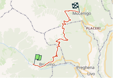
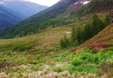
Trail On foot of 12 km to be discovered at Trentino-Alto Adige/Südtirol, Provincia di Trento, Bresimo. This trail is proposed by SityTrail - itinéraires balisés pédestres.
Description
Sentiero Italia CAI 2019
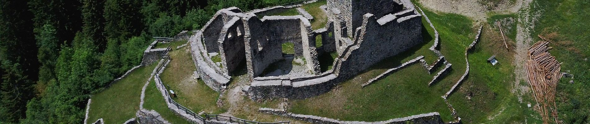
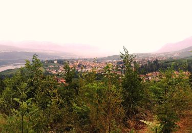
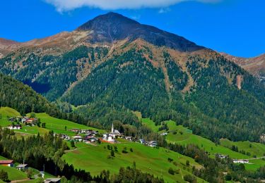
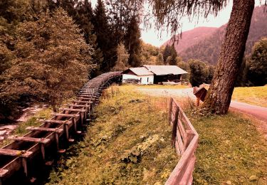
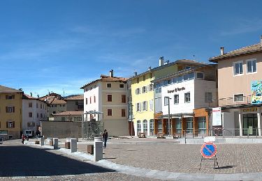
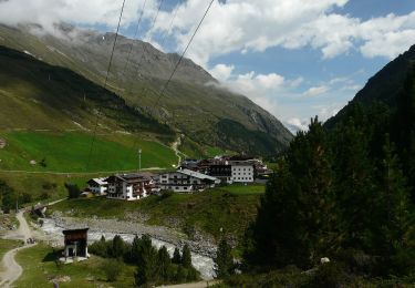
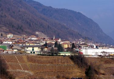
Positioning
Country:
Italy
Region :
Trentino-Alto Adige/Südtirol
Department/Province :
Provincia di Trento
Municipality :
Bresimo
Location:
Unknown
Start:(Dec)
Start:(UTM)
650386 ; 5141653 (32T) N.
Comments
Trails nearby
![Trail On foot Cles - Senter dei Gropi - Photo](https://media.geolcdn.com/t/375/260/b70e4cca-0616-42f0-a792-fc884739f869.jpeg&format=jpg&maxdim=2)
![On foot On foot](https://static1.geolcdn.com/sitytour/trail-icons/100.png)
Senter dei Gropi
On foot
Easy
Cles,
Trentino-Alto Adige/Südtirol,
Provincia di Trento,
Italy
![](/images/other/stat-length.png)
5.7 km | 8.2 km-effort
1h 51min
![](https://static1.geolcdn.com/siteimages/upload/files/16400158638029165_repeat_loop_refresh_sync_direction_icon.png)
No
![Trail On foot Rumo - IT-O147 - Photo](https://media.geolcdn.com/t/375/260/0bb98eef-a0a7-4d3d-a7bf-7ba3389ff19a.jpeg&format=jpg&maxdim=2)
![On foot On foot](https://static1.geolcdn.com/sitytour/trail-icons/100.png)
IT-O147
On foot
Easy
Rumo,
Trentino-Alto Adige/Südtirol,
Provincia di Trento,
Italy
![](/images/other/stat-length.png)
11.8 km | 18.6 km-effort
4h 13min
![](https://static1.geolcdn.com/siteimages/upload/files/16400158638029165_repeat_loop_refresh_sync_direction_icon.png)
No
![Trail On foot Rumo - IT-O149 - Photo](https://media.geolcdn.com/t/375/260/8cc2321c-8caa-402c-9ce0-f7f8c6caf0a2.jpeg&format=jpg&maxdim=2)
![On foot On foot](https://static1.geolcdn.com/sitytour/trail-icons/100.png)
IT-O149
On foot
Medium
Rumo,
Trentino-Alto Adige/Südtirol,
Provincia di Trento,
Italy
![](/images/other/stat-length.png)
12.1 km | 21 km-effort
4h 39min
![](https://static1.geolcdn.com/siteimages/upload/files/16400158638029165_repeat_loop_refresh_sync_direction_icon.png)
No
![Trail On foot Rumo - IT-O131 - Photo](https://media.geolcdn.com/t/375/260/8cc2321c-8caa-402c-9ce0-f7f8c6caf0a2.jpeg&format=jpg&maxdim=2)
![On foot On foot](https://static1.geolcdn.com/sitytour/trail-icons/100.png)
IT-O131
On foot
Medium
Rumo,
Trentino-Alto Adige/Südtirol,
Provincia di Trento,
Italy
![](/images/other/stat-length.png)
9.9 km | 22 km-effort
5h 0min
![](https://static1.geolcdn.com/siteimages/upload/files/16400158638029165_repeat_loop_refresh_sync_direction_icon.png)
No
![Trail On foot Rumo - (SI C06) Mocenigo di Rumo - Passo Fresna - Provés - Malga di Lauregno - Pedra del Gal - Prà della Regola - Castelfondo - Ponte Alto - Fondo - Photo](https://media.geolcdn.com/t/375/260/be52b690-f522-4dd7-8820-f2405c2d8bfe.jpeg&format=jpg&maxdim=2)
![On foot On foot](https://static1.geolcdn.com/sitytour/trail-icons/100.png)
(SI C06) Mocenigo di Rumo - Passo Fresna - Provés - Malga di Lauregno - Pedra...
On foot
Difficult
Rumo,
Trentino-Alto Adige/Südtirol,
Provincia di Trento,
Italy
![](/images/other/stat-length.png)
23 km | 38 km-effort
8h 42min
![](https://static1.geolcdn.com/siteimages/upload/files/16400158638029165_repeat_loop_refresh_sync_direction_icon.png)
No
![Trail On foot Bresimo - IT-O115 - Photo](https://media.geolcdn.com/t/375/260/6d45cdfe-7f71-4472-958d-a9906f240459.jpeg&format=jpg&maxdim=2)
![On foot On foot](https://static1.geolcdn.com/sitytour/trail-icons/100.png)
IT-O115
On foot
Easy
Bresimo,
Trentino-Alto Adige/Südtirol,
Provincia di Trento,
Italy
![](/images/other/stat-length.png)
7.7 km | 17.7 km-effort
4h 0min
![](https://static1.geolcdn.com/siteimages/upload/files/16400158638029165_repeat_loop_refresh_sync_direction_icon.png)
No
![Trail On foot Malé - IT-O117A - Photo](https://media.geolcdn.com/t/375/260/08b8ff52-58c7-4edd-85ad-446e41e262c2.jpeg&format=jpg&maxdim=2)
![On foot On foot](https://static1.geolcdn.com/sitytour/trail-icons/100.png)
IT-O117A
On foot
Easy
Malé,
Trentino-Alto Adige/Südtirol,
Provincia di Trento,
Italy
![](/images/other/stat-length.png)
6.3 km | 11.7 km-effort
2h 39min
![](https://static1.geolcdn.com/siteimages/upload/files/16400158638029165_repeat_loop_refresh_sync_direction_icon.png)
No
![Trail On foot Malé - IT-O118 - Photo](https://media.geolcdn.com/t/375/260/285320f4-87b8-42a6-be3e-1aa0631d38a9.jpeg&format=jpg&maxdim=2)
![On foot On foot](https://static1.geolcdn.com/sitytour/trail-icons/100.png)
IT-O118
On foot
Easy
Malé,
Trentino-Alto Adige/Südtirol,
Provincia di Trento,
Italy
![](/images/other/stat-length.png)
6 km | 12.4 km-effort
2h 49min
![](https://static1.geolcdn.com/siteimages/upload/files/16400158638029165_repeat_loop_refresh_sync_direction_icon.png)
No
![Trail On foot Rumo - IT-O113A - Photo](https://media.geolcdn.com/t/375/260/ext.jpg?maxdim=2&url=https%3A%2F%2Fstatic1.geolcdn.com%2Fsiteimages%2Fupload%2Ffiles%2F1545311037marcheuse_200dpi.jpg)
![On foot On foot](https://static1.geolcdn.com/sitytour/trail-icons/100.png)
IT-O113A
On foot
Medium
Rumo,
Trentino-Alto Adige/Südtirol,
Provincia di Trento,
Italy
![](/images/other/stat-length.png)
7.4 km | 23 km-effort
5h 17min
![](https://static1.geolcdn.com/siteimages/upload/files/16400158638029165_repeat_loop_refresh_sync_direction_icon.png)
No