![](/images/other/stat-length.png)
![Trail On foot Château-Thébaud - Entre Bourg et Maine - Photo](https://media.geolcdn.com/t/1900/400/72eac1be-c58f-4bcc-8fc8-5ad9afa12823.jpeg&format=pjpeg&maxdim=2)
Entre Bourg et Maine
SityTrail - itinéraires balisés pédestres
Tous les sentiers balisés d’Europe GUIDE+
![Length](/images/other/stat-length.png)
Length
5.9 km
![Max alt](https://static1.geolcdn.com/siteimages/upload/files/1508320355ic_sort_altitude_max_24dp.png)
Max alt
42 m
![Uphill gradient](https://static1.geolcdn.com/siteimages/upload/files/1508320355ic_sort_den_pos_24dp.png)
Uphill gradient
87 m
![Km-Effort](/images/other/stat-length.png)
Km-Effort
7 km
![Min alt](https://static1.geolcdn.com/siteimages/upload/files/1508320355ic_sort_altitude_min_24dp.png)
Min alt
8 m
![Downhill gradient](https://static1.geolcdn.com/siteimages/upload/files/1508320355ic_sort_den_neg_24dp.png)
Downhill gradient
87 m
![Boucle](https://static1.geolcdn.com/siteimages/upload/files/16400158638029165_repeat_loop_refresh_sync_direction_icon.png)
Boucle
No
Signpost
Creation date :
2022-02-15 05:44:24.91
Updated on :
2022-03-02 14:28:56.802
![On foot](https://static1.geolcdn.com/sitytour/trail-icons/100.png)
1h35
Difficulty : Easy
![Scan this QR Code to open this trail in the SityTrail application](https://capi.geolives.com/qq0zvz2zws4bq2lad0pu/sitytour/trails/3116102/qr.png?size=200)
FREE GPS app for hiking
About
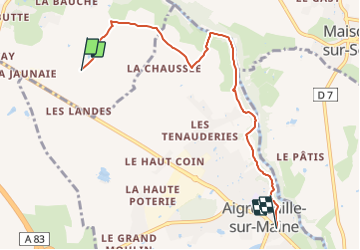
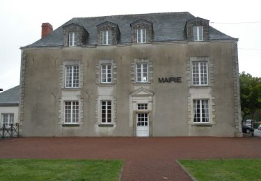
Trail On foot of 5.9 km to be discovered at Pays de la Loire, Loire-Atlantique, Château-Thébaud. This trail is proposed by SityTrail - itinéraires balisés pédestres.
Description
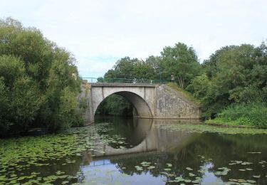
La Maine et ses moulins
Website: https://www.levignobledenantes-tourisme.com/circuit-et-randonnee/boucle-circuit-entre-bourg-et-maine/
Positioning
Country:
France
Region :
Pays de la Loire
Department/Province :
Loire-Atlantique
Municipality :
Château-Thébaud
Location:
Unknown
Start:(Dec)
Start:(UTM)
619079 ; 5216764 (30T) N.
Comments
Trails nearby
![Trail On foot Remouillé - Entre Maine et Gorgeat - Photo](https://media.geolcdn.com/t/375/260/ab5c9464-d5a3-4598-8f50-947285b98d8f.jpeg&format=jpg&maxdim=2)
![On foot On foot](https://static1.geolcdn.com/sitytour/trail-icons/100.png)
Entre Maine et Gorgeat
On foot
Easy
Remouillé,
Pays de la Loire,
Loire-Atlantique,
France
![](/images/other/stat-length.png)
9.4 km | 10.4 km-effort
2h 21min
![](https://static1.geolcdn.com/siteimages/upload/files/16400158638029165_repeat_loop_refresh_sync_direction_icon.png)
Yes
![Trail On foot Château-Thébaud - Le Bois Joly - Photo](https://media.geolcdn.com/t/375/260/506cee01-1922-4b2b-b122-5c1af244be27.jpeg&format=jpg&maxdim=2)
![On foot On foot](https://static1.geolcdn.com/sitytour/trail-icons/100.png)
Le Bois Joly
On foot
Easy
Château-Thébaud,
Pays de la Loire,
Loire-Atlantique,
France
![](/images/other/stat-length.png)
6.9 km | 8.2 km-effort
1h 51min
![](https://static1.geolcdn.com/siteimages/upload/files/16400158638029165_repeat_loop_refresh_sync_direction_icon.png)
Yes
![Trail On foot Maisdon-sur-Sèvre - Soif de Nature - Photo](https://media.geolcdn.com/t/375/260/96221bb9-f267-458a-8e16-f477ffe0731a.jpeg&format=jpg&maxdim=2)
![On foot On foot](https://static1.geolcdn.com/sitytour/trail-icons/100.png)
Soif de Nature
On foot
Easy
Maisdon-sur-Sèvre,
Pays de la Loire,
Loire-Atlantique,
France
![](/images/other/stat-length.png)
14.7 km | 17.1 km-effort
3h 53min
![](https://static1.geolcdn.com/siteimages/upload/files/16400158638029165_repeat_loop_refresh_sync_direction_icon.png)
Yes
![Trail Walking Château-Thébaud - Château Thébaud_Le bois joli - Photo](https://media.geolcdn.com/t/375/260/ext.jpg?maxdim=2&url=https%3A%2F%2Fstatic1.geolcdn.com%2Fsiteimages%2Fupload%2Ffiles%2F1553511878bg_sport_marche.png)
![Walking Walking](https://static1.geolcdn.com/sitytour/trail-icons/101.png)
Château Thébaud_Le bois joli
Walking
Medium
(2)
Château-Thébaud,
Pays de la Loire,
Loire-Atlantique,
France
![](/images/other/stat-length.png)
6.8 km | 8.1 km-effort
1h 46min
![](https://static1.geolcdn.com/siteimages/upload/files/16400158638029165_repeat_loop_refresh_sync_direction_icon.png)
Yes
![Trail Walking Maisdon-sur-Sèvre - Maisdon_Route de la soif - Photo](https://media.geolcdn.com/t/375/260/ext.jpg?maxdim=2&url=https%3A%2F%2Fstatic1.geolcdn.com%2Fsiteimages%2Fupload%2Ffiles%2F1553511878bg_sport_marche.png)
![Walking Walking](https://static1.geolcdn.com/sitytour/trail-icons/101.png)
Maisdon_Route de la soif
Walking
Medium
(1)
Maisdon-sur-Sèvre,
Pays de la Loire,
Loire-Atlantique,
France
![](/images/other/stat-length.png)
13.8 km | 16.1 km-effort
3h 30min
![](https://static1.geolcdn.com/siteimages/upload/files/16400158638029165_repeat_loop_refresh_sync_direction_icon.png)
Yes
![Trail On foot Saint-Lumine-de-Clisson - Circuit des Coteaux Luminais - Photo](https://media.geolcdn.com/t/375/260/31002f39-b83b-4748-839a-c7392ced8026.jpeg&format=jpg&maxdim=2)
![On foot On foot](https://static1.geolcdn.com/sitytour/trail-icons/100.png)
Circuit des Coteaux Luminais
On foot
Easy
Saint-Lumine-de-Clisson,
Pays de la Loire,
Loire-Atlantique,
France
![](/images/other/stat-length.png)
4.6 km | 5.3 km-effort
1h 12min
![](https://static1.geolcdn.com/siteimages/upload/files/16400158638029165_repeat_loop_refresh_sync_direction_icon.png)
Yes
![Trail Walking Aigrefeuille-sur-Maine - Aigrefeuille sur Maine - Photo](https://media.geolcdn.com/t/375/260/ext.jpg?maxdim=2&url=https%3A%2F%2Fstatic1.geolcdn.com%2Fsiteimages%2Fupload%2Ffiles%2F1553511878bg_sport_marche.png)
![Walking Walking](https://static1.geolcdn.com/sitytour/trail-icons/101.png)
Aigrefeuille sur Maine
Walking
Easy
(1)
Aigrefeuille-sur-Maine,
Pays de la Loire,
Loire-Atlantique,
France
![](/images/other/stat-length.png)
10.1 km | 11.4 km-effort
2h 36min
![](https://static1.geolcdn.com/siteimages/upload/files/16400158638029165_repeat_loop_refresh_sync_direction_icon.png)
Yes
![Trail On foot Montbert - Circuit Passerelle - Photo](https://media.geolcdn.com/t/375/260/942b88c9-86ce-47e9-98c8-b2453147c3a3.jpeg&format=jpg&maxdim=2)
![On foot On foot](https://static1.geolcdn.com/sitytour/trail-icons/100.png)
Circuit Passerelle
On foot
Easy
Montbert,
Pays de la Loire,
Loire-Atlantique,
France
![](/images/other/stat-length.png)
13.9 km | 15.1 km-effort
3h 26min
![](https://static1.geolcdn.com/siteimages/upload/files/16400158638029165_repeat_loop_refresh_sync_direction_icon.png)
Yes
![Trail On foot Montbert - Circuit La Foye - Photo](https://media.geolcdn.com/t/375/260/7457a98f-86c1-4e47-b824-f797a1e41dbe.jpeg&format=jpg&maxdim=2)
![On foot On foot](https://static1.geolcdn.com/sitytour/trail-icons/100.png)
Circuit La Foye
On foot
Easy
Montbert,
Pays de la Loire,
Loire-Atlantique,
France
![](/images/other/stat-length.png)
11.3 km | 12.2 km-effort
2h 46min
![](https://static1.geolcdn.com/siteimages/upload/files/16400158638029165_repeat_loop_refresh_sync_direction_icon.png)
Yes