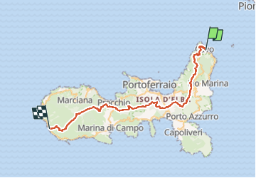
![](/images/other/stat-length.png)
![Trail On foot Rio - GTE - Photo](https://media.geolcdn.com/t/1900/400/ccff2cad-46b8-4ddf-9e94-3729985da97b.jpeg&format=pjpeg&maxdim=2)
GTE
SityTrail - itinéraires balisés pédestres
Tous les sentiers balisés d’Europe GUIDE+
![Length](/images/other/stat-length.png)
Length
48 km
![Max alt](https://static1.geolcdn.com/siteimages/upload/files/1508320355ic_sort_altitude_max_24dp.png)
Max alt
839 m
![Uphill gradient](https://static1.geolcdn.com/siteimages/upload/files/1508320355ic_sort_den_pos_24dp.png)
Uphill gradient
2276 m
![Km-Effort](/images/other/stat-length.png)
Km-Effort
78 km
![Min alt](https://static1.geolcdn.com/siteimages/upload/files/1508320355ic_sort_altitude_min_24dp.png)
Min alt
0 m
![Downhill gradient](https://static1.geolcdn.com/siteimages/upload/files/1508320355ic_sort_den_neg_24dp.png)
Downhill gradient
2256 m
![Boucle](https://static1.geolcdn.com/siteimages/upload/files/16400158638029165_repeat_loop_refresh_sync_direction_icon.png)
Boucle
No
Signpost
Creation date :
2022-02-15 04:23:16.591
Updated on :
2022-03-01 01:21:24.693
![On foot](https://static1.geolcdn.com/sitytour/trail-icons/100.png)
17h43
Difficulty : Very difficult
![Scan this QR Code to open this trail in the SityTrail application](https://capi.geolives.com/qq0zvz2zws4bq2lad0pu/sitytour/trails/3114908/qr.png?size=200)
FREE GPS app for hiking
About
Trail On foot of 48 km to be discovered at Tuscany, Livorno, Rio. This trail is proposed by SityTrail - itinéraires balisés pédestres.
Description
Symbol: GTE on white red flag
Website: https://www.caielba.it/gte-grande-traversata-elbana/
Positioning
Country:
Italy
Region :
Tuscany
Department/Province :
Livorno
Municipality :
Rio
Location:
Unknown
Start:(Dec)
Start:(UTM)
616088 ; 4746216 (32T) N.
Comments
Trails nearby
![Trail On foot Rio - GTE Stage 1 - Photo](https://media.geolcdn.com/t/375/260/7b8d7546-e9bf-494e-9b18-284be6d86cab.jpeg&format=jpg&maxdim=2)
![On foot On foot](https://static1.geolcdn.com/sitytour/trail-icons/100.png)
![Trail Walking Rio - Ile Elbe Nisportino 17.10.22 - Photo](https://media.geolcdn.com/t/375/260/ee77b41d-b4ce-42db-8ee3-22cb521b6203.jpg&format=jpg&maxdim=2)
![Walking Walking](https://static1.geolcdn.com/sitytour/trail-icons/101.png)
Ile Elbe Nisportino 17.10.22
Walking
Medium
Rio,
Tuscany,
Livorno,
Italy
![](/images/other/stat-length.png)
7.8 km | 13.6 km-effort
2h 45min
![](https://static1.geolcdn.com/siteimages/upload/files/16400158638029165_repeat_loop_refresh_sync_direction_icon.png)
Yes
![Trail Walking Rio - Cavo - Photo](https://media.geolcdn.com/t/375/260/1b6989a5-657f-4355-bead-6f4e586d861d.jpg&format=jpg&maxdim=2)
![Walking Walking](https://static1.geolcdn.com/sitytour/trail-icons/101.png)
![Trail Walking Rio - Île d’Elbe - Nisportino - Photo](https://media.geolcdn.com/t/375/260/9d8370fe-d0da-4ffb-a0b5-905dd0ce4717.jpg&format=jpg&maxdim=2)
![Walking Walking](https://static1.geolcdn.com/sitytour/trail-icons/101.png)
Île d’Elbe - Nisportino
Walking
Medium
Rio,
Tuscany,
Livorno,
Italy
![](/images/other/stat-length.png)
8.2 km | 14.1 km-effort
2h 59min
![](https://static1.geolcdn.com/siteimages/upload/files/16400158638029165_repeat_loop_refresh_sync_direction_icon.png)
Yes
![Trail On foot Rio - IT-260 - Photo](https://media.geolcdn.com/t/375/260/676a14c2-bec0-4a38-a436-33daaf4febca.jpeg&format=jpg&maxdim=2)
![On foot On foot](https://static1.geolcdn.com/sitytour/trail-icons/100.png)