![](/images/other/stat-length.png)
![Trail On foot Framura - Framura (Setta) - Costa - Rovereto - Castagnola - Monte Sant'Agata - Photo](https://media.geolcdn.com/t/1900/400/f566bb7c-3946-4951-b36b-20a42e298c78.jpeg&format=pjpeg&maxdim=2)
Framura (Setta) - Costa - Rovereto - Castagnola - Monte Sant'Agata
SityTrail - itinéraires balisés pédestres
Tous les sentiers balisés d’Europe GUIDE+
![Length](/images/other/stat-length.png)
Length
6.3 km
![Max alt](https://static1.geolcdn.com/siteimages/upload/files/1508320355ic_sort_altitude_max_24dp.png)
Max alt
629 m
![Uphill gradient](https://static1.geolcdn.com/siteimages/upload/files/1508320355ic_sort_den_pos_24dp.png)
Uphill gradient
558 m
![Km-Effort](/images/other/stat-length.png)
Km-Effort
12.3 km
![Min alt](https://static1.geolcdn.com/siteimages/upload/files/1508320355ic_sort_altitude_min_24dp.png)
Min alt
163 m
![Downhill gradient](https://static1.geolcdn.com/siteimages/upload/files/1508320355ic_sort_den_neg_24dp.png)
Downhill gradient
121 m
![Boucle](https://static1.geolcdn.com/siteimages/upload/files/16400158638029165_repeat_loop_refresh_sync_direction_icon.png)
Boucle
No
Signpost
Creation date :
2022-02-15 04:05:41.917
Updated on :
2022-03-01 00:46:19.851
![On foot](https://static1.geolcdn.com/sitytour/trail-icons/100.png)
2h47
Difficulty : Easy
![Scan this QR Code to open this trail in the SityTrail application](https://capi.geolives.com/qq0zvz2zws4bq2lad0pu/sitytour/trails/3114725/qr.png?size=200)
FREE GPS app for hiking
About
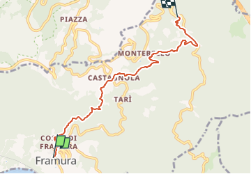
Trail On foot of 6.3 km to be discovered at Liguria, La Spezia, Framura. This trail is proposed by SityTrail - itinéraires balisés pédestres.
Description
relation mantained by AlfredoSP (CAI-SP)
Symbol: some old white red flag
Website: https://www.cailaspezia.it/
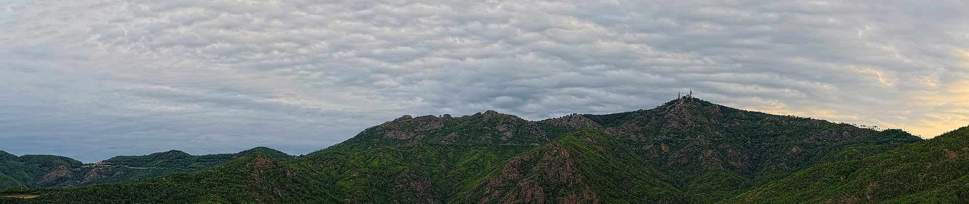
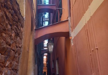
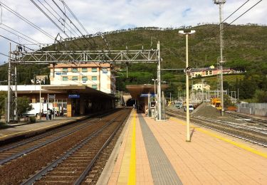
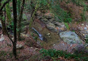
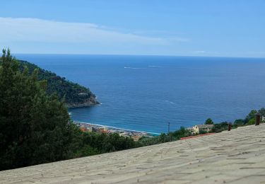
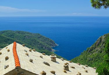
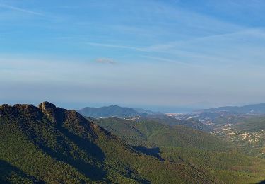
Positioning
Country:
Italy
Region :
Liguria
Department/Province :
La Spezia
Municipality :
Framura
Location:
Unknown
Start:(Dec)
Start:(UTM)
544259 ; 4895269 (32T) N.
Comments
Trails nearby
![Trail Walking Levanto - Levanto - Vernazza 6.5.23 - Photo](https://media.geolcdn.com/t/375/260/0287dcd3-7795-4c8b-8f35-962c00e797c3.jpg&format=jpg&maxdim=2)
![Walking Walking](https://static1.geolcdn.com/sitytour/trail-icons/101.png)
Levanto - Vernazza 6.5.23
Walking
Difficult
Levanto,
Liguria,
La Spezia,
Italy
![](/images/other/stat-length.png)
14.1 km | 23 km-effort
5h 0min
![](https://static1.geolcdn.com/siteimages/upload/files/16400158638029165_repeat_loop_refresh_sync_direction_icon.png)
No
![Trail On foot Levanto - Vallesanta - Monte delle Streghe - Colletto - Photo](https://media.geolcdn.com/t/375/260/efa63fd2-8e4e-4cf6-bbf2-2f4e4541a575.jpeg&format=jpg&maxdim=2)
![On foot On foot](https://static1.geolcdn.com/sitytour/trail-icons/100.png)
Vallesanta - Monte delle Streghe - Colletto
On foot
Easy
Levanto,
Liguria,
La Spezia,
Italy
![](/images/other/stat-length.png)
4.6 km | 9.5 km-effort
2h 9min
![](https://static1.geolcdn.com/siteimages/upload/files/16400158638029165_repeat_loop_refresh_sync_direction_icon.png)
No
![Trail On foot Bonassola - Reggimonti - Monte Gaggi - S.P. 64 - Monte Grumo - Photo](https://media.geolcdn.com/t/375/260/53b7c24f-114d-496d-8324-7d9132d796d3.jpeg&format=jpg&maxdim=2)
![On foot On foot](https://static1.geolcdn.com/sitytour/trail-icons/100.png)
Reggimonti - Monte Gaggi - S.P. 64 - Monte Grumo
On foot
Easy
Bonassola,
Liguria,
La Spezia,
Italy
![](/images/other/stat-length.png)
3.7 km | 7 km-effort
1h 34min
![](https://static1.geolcdn.com/siteimages/upload/files/16400158638029165_repeat_loop_refresh_sync_direction_icon.png)
No
![Trail On foot Bonassola - Bonassola - Salto della Lepre - Pastorelli - Montaretto - Photo](https://media.geolcdn.com/t/375/260/a7cea6e7-bc07-4258-9020-ad0c6abe0784.jpeg&format=jpg&maxdim=2)
![On foot On foot](https://static1.geolcdn.com/sitytour/trail-icons/100.png)
Bonassola - Salto della Lepre - Pastorelli - Montaretto
On foot
Easy
Bonassola,
Liguria,
La Spezia,
Italy
![](/images/other/stat-length.png)
3 km | 4.2 km-effort
57min
![](https://static1.geolcdn.com/siteimages/upload/files/16400158638029165_repeat_loop_refresh_sync_direction_icon.png)
No
![Trail On foot Framura - Vandarecca - Montaretto - Reggimonti – Bivio AV5T - Photo](https://media.geolcdn.com/t/375/260/433b5181-ce40-4552-b8f8-d309475f0ca2.jpeg&format=jpg&maxdim=2)
![On foot On foot](https://static1.geolcdn.com/sitytour/trail-icons/100.png)
Vandarecca - Montaretto - Reggimonti – Bivio AV5T
On foot
Easy
Framura,
Liguria,
La Spezia,
Italy
![](/images/other/stat-length.png)
6 km | 11.9 km-effort
2h 42min
![](https://static1.geolcdn.com/siteimages/upload/files/16400158638029165_repeat_loop_refresh_sync_direction_icon.png)
No
![Trail On foot Moneglia - Sella Crocetta (Bivio SVA) – Salto del Cavallo – Baracchino – Monte San Nicolao - Photo](https://media.geolcdn.com/t/375/260/5ff27ab8-192d-41d8-9ca3-8d68829dd71b.jpeg&format=jpg&maxdim=2)
![On foot On foot](https://static1.geolcdn.com/sitytour/trail-icons/100.png)
Sella Crocetta (Bivio SVA) – Salto del Cavallo – Baracchino – Monte San Nicolao
On foot
Easy
Moneglia,
Liguria,
Genoa,
Italy
![](/images/other/stat-length.png)
7.9 km | 14.2 km-effort
3h 14min
![](https://static1.geolcdn.com/siteimages/upload/files/16400158638029165_repeat_loop_refresh_sync_direction_icon.png)
No
![Trail On foot Carrodano - Colle Gruzze (Quattro Strade) - Canegreca - Foce di Vaggi - Photo](https://media.geolcdn.com/t/375/260/f43187b3-05f0-4e1d-ad74-3d495779203d.jpeg&format=jpg&maxdim=2)
![On foot On foot](https://static1.geolcdn.com/sitytour/trail-icons/100.png)
Colle Gruzze (Quattro Strade) - Canegreca - Foce di Vaggi
On foot
Easy
Carrodano,
Liguria,
La Spezia,
Italy
![](/images/other/stat-length.png)
4.7 km | 8.5 km-effort
1h 56min
![](https://static1.geolcdn.com/siteimages/upload/files/16400158638029165_repeat_loop_refresh_sync_direction_icon.png)
No
![Trail On foot Levanto - sejour-cinque-terre-journee-2-levanto-vernazza - Photo](https://media.geolcdn.com/t/375/260/3f2e0a3d-9aaf-4a9d-8677-4481d4ba0aac.jpg&format=jpg&maxdim=2)
![On foot On foot](https://static1.geolcdn.com/sitytour/trail-icons/100.png)
sejour-cinque-terre-journee-2-levanto-vernazza
On foot
Medium
Levanto,
Liguria,
La Spezia,
Italy
![](/images/other/stat-length.png)
27 km | 39 km-effort
Unknown
![](https://static1.geolcdn.com/siteimages/upload/files/16400158638029165_repeat_loop_refresh_sync_direction_icon.png)
No
![Trail Walking Deiva Marina - Séjour Cinque Terre - Journée 1 - Deiva Marina - Bonassola - Photo](https://media.geolcdn.com/t/375/260/b24c6297-dd4b-4ed9-b39c-778da18fcabf.jpg&format=jpg&maxdim=2)
![Walking Walking](https://static1.geolcdn.com/sitytour/trail-icons/101.png)
Séjour Cinque Terre - Journée 1 - Deiva Marina - Bonassola
Walking
Medium
Deiva Marina,
Liguria,
La Spezia,
Italy
![](/images/other/stat-length.png)
23 km | 34 km-effort
Unknown
![](https://static1.geolcdn.com/siteimages/upload/files/16400158638029165_repeat_loop_refresh_sync_direction_icon.png)
No