![](/images/other/stat-length.png)
![Trail On foot San Martino Canavese - Alta Via dell’Anfiteatro Morenico di Ivrea - Itinerario di Collegamento di San Martino Canavese, Direzione Sud - Photo](https://media.geolcdn.com/t/1900/400/ext.pjpeg?maxdim=2&url=https%3A%2F%2Fstatic1.geolcdn.com%2Fsiteimages%2Fupload%2Ffiles%2F1545311037marcheuse_200dpi.jpg)
Alta Via dell’Anfiteatro Morenico di Ivrea - Itinerario di Collegamento di San Martino Canavese, Direzione Sud
SityTrail - itinéraires balisés pédestres
Tous les sentiers balisés d’Europe GUIDE+
![Length](/images/other/stat-length.png)
Length
3.3 km
![Max alt](https://static1.geolcdn.com/siteimages/upload/files/1508320355ic_sort_altitude_max_24dp.png)
Max alt
442 m
![Uphill gradient](https://static1.geolcdn.com/siteimages/upload/files/1508320355ic_sort_den_pos_24dp.png)
Uphill gradient
105 m
![Km-Effort](/images/other/stat-length.png)
Km-Effort
4.5 km
![Min alt](https://static1.geolcdn.com/siteimages/upload/files/1508320355ic_sort_altitude_min_24dp.png)
Min alt
342 m
![Downhill gradient](https://static1.geolcdn.com/siteimages/upload/files/1508320355ic_sort_den_neg_24dp.png)
Downhill gradient
63 m
![Boucle](https://static1.geolcdn.com/siteimages/upload/files/16400158638029165_repeat_loop_refresh_sync_direction_icon.png)
Boucle
No
Signpost
Creation date :
2022-02-15 02:38:52.836
Updated on :
2022-02-28 23:29:19.282
![On foot](https://static1.geolcdn.com/sitytour/trail-icons/100.png)
1h01
Difficulty : Easy
![Scan this QR Code to open this trail in the SityTrail application](https://capi.geolives.com/qq0zvz2zws4bq2lad0pu/sitytour/trails/3114196/qr.png?size=200)
FREE GPS app for hiking
About
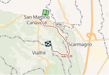
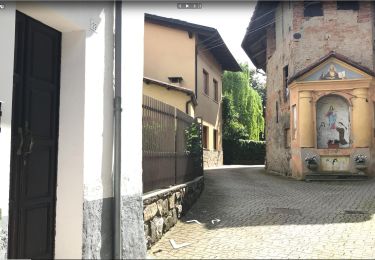
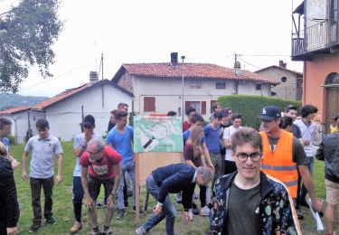
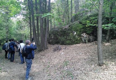
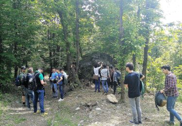
Trail On foot of 3.3 km to be discovered at Piemont, Torino, San Martino Canavese. This trail is proposed by SityTrail - itinéraires balisés pédestres.
Description
Trail created by Ecomuseo dell’Anfiteatro Morenico di Ivrea ( AMI ).
Symbol: two white triangles vertically opposed on a red background
Positioning
Country:
Italy
Region :
Piemont
Department/Province :
Torino
Municipality :
San Martino Canavese
Location:
Unknown
Start:(Dec)
Start:(UTM)
407586 ; 5027447 (32T) N.
Comments
Trails nearby
![Trail On foot Castellamonte - ETOP103000A - Photo](https://media.geolcdn.com/t/375/260/63015f0a-04a9-4a7e-8c85-e40af8987184.jpeg&format=jpg&maxdim=2)
![On foot On foot](https://static1.geolcdn.com/sitytour/trail-icons/100.png)
![Trail On foot Strambinello - ETON7220000 - Photo](https://media.geolcdn.com/t/375/260/944a6ebd-2aa3-4d72-b65e-653d7de80922.jpeg&format=jpg&maxdim=2)
![On foot On foot](https://static1.geolcdn.com/sitytour/trail-icons/100.png)
![Trail On foot Vialfrè - Sentiero dei massi erratici - Photo](https://media.geolcdn.com/t/375/260/e0da5e0e-7d06-433f-bc29-5bd71ec1ac14.jpeg&format=jpg&maxdim=2)
![On foot On foot](https://static1.geolcdn.com/sitytour/trail-icons/100.png)
Sentiero dei massi erratici
On foot
Easy
Vialfrè,
Piemont,
Torino,
Italy
![](/images/other/stat-length.png)
7.2 km | 8.8 km-effort
2h 0min
![](https://static1.geolcdn.com/siteimages/upload/files/16400158638029165_repeat_loop_refresh_sync_direction_icon.png)
Yes
![Trail On foot Vialfrè - Castellamonte fraz. Pricco, bivio TOP100 - Vialfre', bivio TOP100-TOP101 - Photo](https://media.geolcdn.com/t/375/260/9208ca07-9281-4e8f-abb2-762b7048c1d1.jpeg&format=jpg&maxdim=2)
![On foot On foot](https://static1.geolcdn.com/sitytour/trail-icons/100.png)
Castellamonte fraz. Pricco, bivio TOP100 - Vialfre', bivio TOP100-TOP101
On foot
Easy
Vialfrè,
Piemont,
Torino,
Italy
![](/images/other/stat-length.png)
6.2 km | 7.2 km-effort
1h 38min
![](https://static1.geolcdn.com/siteimages/upload/files/16400158638029165_repeat_loop_refresh_sync_direction_icon.png)
No
![Trail On foot Vialfrè - Strambinello -Vialfrè - Photo](https://media.geolcdn.com/t/375/260/430909ee-a21e-4ca5-9086-77cc105a86a8.jpeg&format=jpg&maxdim=2)
![On foot On foot](https://static1.geolcdn.com/sitytour/trail-icons/100.png)
Strambinello -Vialfrè
On foot
Medium
Vialfrè,
Piemont,
Torino,
Italy
![](/images/other/stat-length.png)
16.5 km | 22 km-effort
4h 55min
![](https://static1.geolcdn.com/siteimages/upload/files/16400158638029165_repeat_loop_refresh_sync_direction_icon.png)
No
![Trail On foot Vialfrè - Candia Canavese, bivio102-Vialfre', bivio103 - Photo](https://media.geolcdn.com/t/375/260/ac389d80-78e4-4588-9c36-72769b9c2fc4.jpeg&format=jpg&maxdim=2)
![On foot On foot](https://static1.geolcdn.com/sitytour/trail-icons/100.png)
Candia Canavese, bivio102-Vialfre', bivio103
On foot
Easy
Vialfrè,
Piemont,
Torino,
Italy
![](/images/other/stat-length.png)
11.6 km | 14.3 km-effort
3h 14min
![](https://static1.geolcdn.com/siteimages/upload/files/16400158638029165_repeat_loop_refresh_sync_direction_icon.png)
No
![Trail On foot Agliè - Alta Via dell’Anfiteatro Morenico di Ivrea - Itinerario di Collegamento di Agliè - Photo](https://media.geolcdn.com/t/375/260/0ec7e7cc-74f3-4dcc-b809-34a0f0219c58.jpeg&format=jpg&maxdim=2)
![On foot On foot](https://static1.geolcdn.com/sitytour/trail-icons/100.png)
Alta Via dell’Anfiteatro Morenico di Ivrea - Itinerario di Collegamento di Agliè
On foot
Easy
Agliè,
Piemont,
Torino,
Italy
![](/images/other/stat-length.png)
4.1 km | 5.7 km-effort
1h 17min
![](https://static1.geolcdn.com/siteimages/upload/files/16400158638029165_repeat_loop_refresh_sync_direction_icon.png)
No
![Trail On foot Torre Canavese - Alta Via dell'Anfiteatro Morenico di Ivrea - Photo](https://media.geolcdn.com/t/375/260/aab52108-3181-4f7d-8729-387e20b6d5a2.jpeg&format=jpg&maxdim=2)
![On foot On foot](https://static1.geolcdn.com/sitytour/trail-icons/100.png)
Alta Via dell'Anfiteatro Morenico di Ivrea
On foot
Medium
Torre Canavese,
Piemont,
Torino,
Italy
![](/images/other/stat-length.png)
17.1 km | 22 km-effort
5h 0min
![](https://static1.geolcdn.com/siteimages/upload/files/16400158638029165_repeat_loop_refresh_sync_direction_icon.png)
No
![Trail On foot Romano Canavese - Alta Via dell’Anfiteatro Morenico di Ivrea - Itinerario di Collegamento di Romano Canavese - Photo](https://media.geolcdn.com/t/375/260/3ce438cc-8215-4b72-b955-b9ab23fef254.jpeg&format=jpg&maxdim=2)
![On foot On foot](https://static1.geolcdn.com/sitytour/trail-icons/100.png)
Alta Via dell’Anfiteatro Morenico di Ivrea - Itinerario di Collegamento di Ro...
On foot
Easy
Romano Canavese,
Piemont,
Torino,
Italy
![](/images/other/stat-length.png)
9.4 km | 12 km-effort
2h 43min
![](https://static1.geolcdn.com/siteimages/upload/files/16400158638029165_repeat_loop_refresh_sync_direction_icon.png)
No