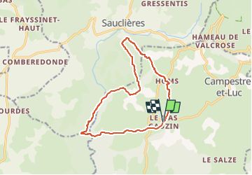
![](/images/other/stat-length.png)
![Trail On foot Campestre-et-Luc - Le Causse de Campestre - Photo](https://media.geolcdn.com/t/1900/400/ext.pjpeg?maxdim=2&url=https%3A%2F%2Fstatic1.geolcdn.com%2Fsiteimages%2Fupload%2Ffiles%2F1545311037marcheuse_200dpi.jpg)
Le Causse de Campestre
SityTrail - itinéraires balisés pédestres
Tous les sentiers balisés d’Europe GUIDE+
![Length](/images/other/stat-length.png)
Length
14.3 km
![Max alt](https://static1.geolcdn.com/siteimages/upload/files/1508320355ic_sort_altitude_max_24dp.png)
Max alt
854 m
![Uphill gradient](https://static1.geolcdn.com/siteimages/upload/files/1508320355ic_sort_den_pos_24dp.png)
Uphill gradient
349 m
![Km-Effort](/images/other/stat-length.png)
Km-Effort
18.9 km
![Min alt](https://static1.geolcdn.com/siteimages/upload/files/1508320355ic_sort_altitude_min_24dp.png)
Min alt
684 m
![Downhill gradient](https://static1.geolcdn.com/siteimages/upload/files/1508320355ic_sort_den_neg_24dp.png)
Downhill gradient
348 m
![Boucle](https://static1.geolcdn.com/siteimages/upload/files/16400158638029165_repeat_loop_refresh_sync_direction_icon.png)
Boucle
Yes
Signpost
Creation date :
2022-02-15 02:38:27.644
Updated on :
2022-03-02 11:28:50.502
![On foot](https://static1.geolcdn.com/sitytour/trail-icons/100.png)
4h17
Difficulty : Easy
![Scan this QR Code to open this trail in the SityTrail application](https://capi.geolives.com/qq0zvz2zws4bq2lad0pu/sitytour/trails/3114169/qr.png?size=200)
FREE GPS app for hiking
About
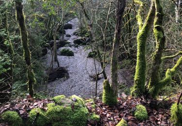
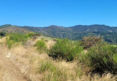
Trail On foot of 14.3 km to be discovered at Occitania, Gard, Campestre-et-Luc. This trail is proposed by SityTrail - itinéraires balisés pédestres.
Description
Website: http://randonnee.cevenole.free.fr/index.php5?modele=Campestre&vue=topo
Positioning
Country:
France
Region :
Occitania
Department/Province :
Gard
Municipality :
Campestre-et-Luc
Location:
Unknown
Start:(Dec)
Start:(UTM)
531090 ; 4865390 (31T) N.
Comments
Trails nearby
![Trail Walking Alzon - Alzon - Photo](https://media.geolcdn.com/t/375/260/bed55352-0ab2-4a5d-b760-65258f414d00.jpg&format=jpg&maxdim=2)
![Walking Walking](https://static1.geolcdn.com/sitytour/trail-icons/101.png)
![Trail Walking Campestre-et-Luc - Campestre - Photo](https://media.geolcdn.com/t/375/260/efbf11fd-a04d-4fac-a4bc-0e49cb208a80.jpg&format=jpg&maxdim=2)
![Walking Walking](https://static1.geolcdn.com/sitytour/trail-icons/101.png)
Campestre
Walking
Medium
Campestre-et-Luc,
Occitania,
Gard,
France
![](/images/other/stat-length.png)
7.3 km | 8.7 km-effort
1h 55min
![](https://static1.geolcdn.com/siteimages/upload/files/16400158638029165_repeat_loop_refresh_sync_direction_icon.png)
Yes
![Trail Walking Alzon - vers le St guiral puis le rocher de l'aigle - Photo](https://media.geolcdn.com/t/375/260/f78318b9-9f52-40d1-b483-cd5ef15a47bd.jpg&format=jpg&maxdim=2)
![Walking Walking](https://static1.geolcdn.com/sitytour/trail-icons/101.png)
vers le St guiral puis le rocher de l'aigle
Walking
Difficult
(1)
Alzon,
Occitania,
Gard,
France
![](/images/other/stat-length.png)
17.7 km | 29 km-effort
6h 51min
![](https://static1.geolcdn.com/siteimages/upload/files/16400158638029165_repeat_loop_refresh_sync_direction_icon.png)
Yes
![Trail Walking Sauclières - Sauciers le causse de campestre - Photo](https://media.geolcdn.com/t/375/260/170fd80e-d069-4c7a-bb3a-db5683ae9d39.jpg&format=jpg&maxdim=2)
![Walking Walking](https://static1.geolcdn.com/sitytour/trail-icons/101.png)
Sauciers le causse de campestre
Walking
Difficult
Sauclières,
Occitania,
Aveyron,
France
![](/images/other/stat-length.png)
16.9 km | 22 km-effort
5h 37min
![](https://static1.geolcdn.com/siteimages/upload/files/16400158638029165_repeat_loop_refresh_sync_direction_icon.png)
No
![Trail Walking Alzon - mont guiral - Photo](https://media.geolcdn.com/t/375/260/bcfc8b55-a7b6-45a0-94f3-6dc53536727d.jpg&format=jpg&maxdim=2)
![Walking Walking](https://static1.geolcdn.com/sitytour/trail-icons/101.png)
![Trail Walking Sauclières - Sauclières, passage à la perte de la Virenque, le Pouget, retour Sauclières - Photo](https://media.geolcdn.com/t/375/260/ext.jpg?maxdim=2&url=https%3A%2F%2Fstatic1.geolcdn.com%2Fsiteimages%2Fupload%2Ffiles%2F1553511878bg_sport_marche.png)
![Walking Walking](https://static1.geolcdn.com/sitytour/trail-icons/101.png)
Sauclières, passage à la perte de la Virenque, le Pouget, retour Sauclières
Walking
Medium
Sauclières,
Occitania,
Aveyron,
France
![](/images/other/stat-length.png)
11.8 km | 16.5 km-effort
1h 53min
![](https://static1.geolcdn.com/siteimages/upload/files/16400158638029165_repeat_loop_refresh_sync_direction_icon.png)
Yes
![Trail Mountain bike Sauclières - Sauclières Algues Le liquier Sauclières - Photo](https://media.geolcdn.com/t/375/260/ext.jpg?maxdim=2&url=https%3A%2F%2Fstatic1.geolcdn.com%2Fsiteimages%2Fupload%2Ffiles%2F1524743154velo.jpg)
![Mountain bike Mountain bike](https://static1.geolcdn.com/sitytour/trail-icons/202.png)
Sauclières Algues Le liquier Sauclières
Mountain bike
Medium
Sauclières,
Occitania,
Aveyron,
France
![](/images/other/stat-length.png)
25 km | 34 km-effort
2h 19min
![](https://static1.geolcdn.com/siteimages/upload/files/16400158638029165_repeat_loop_refresh_sync_direction_icon.png)
Yes
![Trail Walking Sauclières - Sauclières (causse de Campestre) - Photo](https://media.geolcdn.com/t/375/260/ext.jpg?maxdim=2&url=https%3A%2F%2Fstatic1.geolcdn.com%2Fsiteimages%2Fupload%2Ffiles%2F1553511878bg_sport_marche.png)
![Walking Walking](https://static1.geolcdn.com/sitytour/trail-icons/101.png)
Sauclières (causse de Campestre)
Walking
Easy
Sauclières,
Occitania,
Aveyron,
France
![](/images/other/stat-length.png)
16.9 km | 23 km-effort
5h 25min
![](https://static1.geolcdn.com/siteimages/upload/files/16400158638029165_repeat_loop_refresh_sync_direction_icon.png)
Yes
![Trail Walking Alzon - Gard - Alzon Le col de la Barriere Truc de Jaoul 13km 418m - Photo](https://media.geolcdn.com/t/375/260/ext.jpg?maxdim=2&url=https%3A%2F%2Fstatic1.geolcdn.com%2Fsiteimages%2Fupload%2Ffiles%2F1553511878bg_sport_marche.png)
![Walking Walking](https://static1.geolcdn.com/sitytour/trail-icons/101.png)
Gard - Alzon Le col de la Barriere Truc de Jaoul 13km 418m
Walking
Very easy
Alzon,
Occitania,
Gard,
France
![](/images/other/stat-length.png)
12.8 km | 18.6 km-effort
Unknown
![](https://static1.geolcdn.com/siteimages/upload/files/16400158638029165_repeat_loop_refresh_sync_direction_icon.png)
Yes