Trail On foot Valbondione - Sentiero delle Orobie Orientali - Tappa 6 - Photo

Sentiero delle Orobie Orientali - Tappa 6

Tous les sentiers balisés d’Europe PRO

© OpenStreetMap contributors
Length
Length
5.7 km
Max alt
Max alt
2346 m
Uphill gradient
Uphill gradient
589 m
Km-Effort
Km-Effort  
13.5 km
Min alt
Min alt
1798 m
Downhill gradient
Downhill gradient
569 m
Boucle
Boucle
No
Signpost
Signpost
Creation date :
2022-02-15 00:55:45.119
Updated on :
2022-02-28 19:53:20.468

(0 Reviews)

On foot
On foot
3h03
Difficulty : Easy

Scan this QR Code to open this trail in the SityTrail application

FREE GPS app for hiking

Logo SityTrail SityTrail

IGN / Geographical institutes

Download SityTrail from the App Store Download SityTrail from Google Play

Logo SityTrail SityTrail World

The world is yours!

Download SityTrail from the App Store Download SityTrail from Google Play Download SityTrail on Huawei AppGallery

About

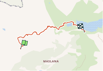
Trail On foot of 5.7 km to be discovered at Lombardy, Bergamo, Valbondione. This trail is proposed by SityTrail - itinéraires balisés pédestres.

Description

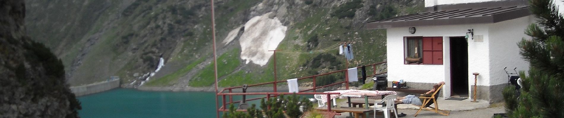
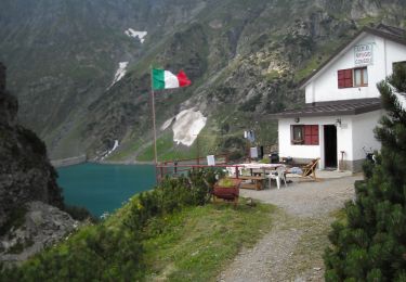
SENTIERO DELLE OROBIE (orientali)NB: Il tempo di percorrenza per questo sentiero è quello mediamente impiegato da un escursionista allenato (escluse le soste). Visto il tipo di fondo spesso "delicato" ove bisogna procedere con attenzione, questo tempo potrà variare anche di molto in base alle capacità ed allenamento del singolo escursionista.

Website: http://geoportale.caibergamo.it/sentiero/303

Photos

Positioning

Country:
Italy
Region :
Lombardy
Department/Province :
Bergamo
Municipality :
Valbondione
Location:
Unknown
Start:(UTM)
578101 ; 5100622 (32T) N.

Trails nearby

Trail On foot Vilminore di Scalve - IT-407 - Photo
On foot
PRO

On foot

Easy
Vilminore di Scalve, Lombardy, Bergamo, Italy
3 km | 5.4 km-effort
1h 13min
No
Trail On foot Valbondione - (SI D21S) Rifugio Mario Merelli al Coca - Rifugio Antonio Curò - Photo
On foot
PRO

On foot

Easy
Valbondione, Lombardy, Bergamo, Italy
5.7 km | 13.5 km-effort
3h 3min
No
Trail On foot Valbondione - (SI D22S) Rifugio Antonio Curò - Rifugio Nani Tagliaferri al Passo di Venano - Photo
On foot
PRO

On foot

Medium
Valbondione, Lombardy, Bergamo, Italy
8 km | 20 km-effort
4h 32min
No
Trail On foot Valbondione - 227: Fiumenero - Rifugio Baroni al Brunone - Photo
On foot
PRO

On foot

Medium
Valbondione, Lombardy, Bergamo, Italy
7 km | 21 km-effort
4h 52min
No
Trail On foot Valbondione - 323: Rifugio Coca - Bocchetta del Camoscio - Rifugio Curò - Photo
On foot
PRO

On foot

Easy
Valbondione, Lombardy, Bergamo, Italy
7.4 km | 19.8 km-effort
4h 30min
No
Trail On foot Valbondione - Sentiero delle Orobie Orientali - Tappa 7 - Photo
On foot
PRO

On foot

Difficult
Valbondione, Lombardy, Bergamo, Italy
17.7 km | 33 km-effort
7h 32min
No
Trail On foot Valbondione - 321: Rifugio Curò - Rifugio Tagliaferri - Photo
On foot
PRO

On foot

Easy
Valbondione, Lombardy, Bergamo, Italy
7.8 km | 18.7 km-effort
4h 15min
No
Trail On foot Valbondione - 305: Valbondione - Rifugio Curò - Photo
On foot
PRO

On foot

Easy
Valbondione, Lombardy, Bergamo, Italy
6.3 km | 9.7 km-effort
2h 12min
No
Trail On foot Valbondione - Sentiero Basso Brunone-Coca - Photo
On foot
PRO

On foot

Medium
Valbondione, Lombardy, Bergamo, Italy
9.6 km | 22 km-effort
5h 6min
No


Close
My subscriptions