Trail On foot Panicale - Mongiovino - Buca Calcinaro - Photo

Mongiovino - Buca Calcinaro

Tous les sentiers balisés d’Europe PRO

© OpenStreetMap contributors
Length
Length
10.8 km
Max alt
Max alt
524 m
Uphill gradient
Uphill gradient
418 m
Km-Effort
Km-Effort  
16.3 km
Min alt
Min alt
288 m
Downhill gradient
Downhill gradient
415 m
Boucle
Boucle
Yes
Signpost
Signpost
Creation date :
2022-02-15 00:35:13.235
Updated on :
2022-02-28 19:26:58.717

(0 Reviews)

On foot
On foot
3h42
Difficulty : Easy

Scan this QR Code to open this trail in the SityTrail application

FREE GPS app for hiking

Logo SityTrail SityTrail

IGN / Geographical institutes

Download SityTrail from the App Store Download SityTrail from Google Play

Logo SityTrail SityTrail World

The world is yours!

Download SityTrail from the App Store Download SityTrail from Google Play Download SityTrail on Huawei AppGallery

About

Trail On foot of 10.8 km to be discovered at Umbria, Perugia, Panicale. This trail is proposed by SityTrail - itinéraires balisés pédestres.

Description

Trail created by Parco regionale del Lago Trasimeno.

number of itinerary being updated Umbria Excursion Network

Photos

Positioning

Country:
Italy
Region :
Umbria
Department/Province :
Perugia
Municipality :
Panicale
Location:
Unknown
Start:(UTM)
267532 ; 4766185 (33T) N.

Trails nearby

Trail On foot Perugia - Fontignano - Montali - M. Solare - Photo
On foot
PRO

On foot

Medium
Perugia, Umbria, Perugia, Italy
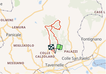
14.3 km | 20 km-effort
4h 36min
Yes
Trail On foot Panicale - Missiano - Monte Petrarvella - Panicale - Photo
On foot
PRO

On foot

Easy
Panicale, Umbria, Perugia, Italy
8.3 km | 13 km-effort
2h 57min
Yes


Close
My subscriptions