Trail On foot Tuoro sul Trasimeno - Sanguineto - Monte Gualandro - Photo

Sanguineto - Monte Gualandro

Tous les sentiers balisés d’Europe PRO

© OpenStreetMap contributors
Length
Length
11.3 km
Max alt
Max alt
555 m
Uphill gradient
Uphill gradient
351 m
Km-Effort
Km-Effort  
16 km
Min alt
Min alt
272 m
Downhill gradient
Downhill gradient
347 m
Boucle
Boucle
Yes
Signpost
Signpost
Creation date :
2022-02-15 00:31:51.279
Updated on :
2022-02-28 19:18:12.781

(0 Reviews)

On foot
On foot
3h37
Difficulty : Easy

Scan this QR Code to open this trail in the SityTrail application

FREE GPS app for hiking

Logo SityTrail SityTrail

IGN / Geographical institutes

Download SityTrail from the App Store Download SityTrail from Google Play

Logo SityTrail SityTrail World

The world is yours!

Download SityTrail from the App Store Download SityTrail from Google Play Download SityTrail on Huawei AppGallery

About

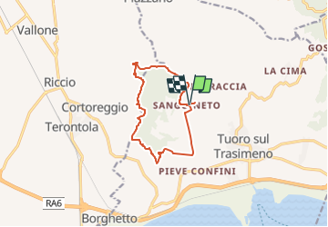
Trail On foot of 11.3 km to be discovered at Umbria, Perugia, Tuoro sul Trasimeno. This trail is proposed by SityTrail - itinéraires balisés pédestres.

Description

Trail created by Parco regionale del Lago Trasimeno.

number of itinerary being updated Umbria Excursion Network


Website: http://www.caiperugia.it/

Photos

Positioning

Country:
Italy
Region :
Umbria
Department/Province :
Perugia
Municipality :
Tuoro sul Trasimeno
Location:
Unknown
Start:(UTM)
260753 ; 4789269 (33T) N.

Trails nearby

Trail On foot Tuoro sul Trasimeno - Sentiero Frassati - Photo
On foot
PRO

On foot

Easy
Tuoro sul Trasimeno, Umbria, Perugia, Italy
10.1 km | 15.2 km-effort
3h 27min
Yes
Trail On foot Tuoro sul Trasimeno - Borgo Torale-Pischiello-Poggio Bandito-Convento Cappuccini - Photo
On foot
PRO

On foot

Easy
Tuoro sul Trasimeno, Umbria, Perugia, Italy
14 km | 19.8 km-effort
4h 30min
Yes
Trail Walking Cortona - w-italie-terontola-het-lago-trasimeno - Photo
Walking
gpstracks

Walking

Very easy
Cortona, Tuscany, Arezzo, Italy
18.2 km | 23 km-effort
Unknown
No


Close
My subscriptions