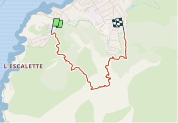
![](/images/other/stat-length.png)
![Trail On foot Marseille - FR-1 - Photo](https://media.geolcdn.com/t/1900/400/bc3bf1c1-4e6d-4ecd-b741-b7754447ebb3.jpeg&format=pjpeg&maxdim=2)
FR-1
SityTrail - itinéraires balisés pédestres
Tous les sentiers balisés d’Europe GUIDE+
![Length](/images/other/stat-length.png)
![Max alt](https://static1.geolcdn.com/siteimages/upload/files/1508320355ic_sort_altitude_max_24dp.png)
![Uphill gradient](https://static1.geolcdn.com/siteimages/upload/files/1508320355ic_sort_den_pos_24dp.png)
![Km-Effort](/images/other/stat-length.png)
![Min alt](https://static1.geolcdn.com/siteimages/upload/files/1508320355ic_sort_altitude_min_24dp.png)
![Downhill gradient](https://static1.geolcdn.com/siteimages/upload/files/1508320355ic_sort_den_neg_24dp.png)
![Boucle](https://static1.geolcdn.com/siteimages/upload/files/16400158638029165_repeat_loop_refresh_sync_direction_icon.png)
![On foot](https://static1.geolcdn.com/sitytour/trail-icons/100.png)
1h37
Difficulty : Easy
![Scan this QR Code to open this trail in the SityTrail application](https://capi.geolives.com/qq0zvz2zws4bq2lad0pu/sitytour/trails/3112627/qr.png?size=200)
FREE GPS app for hiking
About
Trail On foot of 3 km to be discovered at Provence-Alpes-Côte d'Azur, Bouches-du-Rhône, Marseille. This trail is proposed by SityTrail - itinéraires balisés pédestres.
Description
Trail created by CG13.
Début de l'itinéraire vu au début de la piste entre la Madrague et Saména. Fin de l'itinéraire vue en haut du Bd de la grotte Rolland.
Symbol: Brown bar
Positioning
Comments
Trails nearby
![Trail Mountain bike Marseille - OR-6270829--Marseille:Trilogie des Calanques - Photo](https://media.geolcdn.com/t/375/260/37b85b5c-5918-4ab9-a017-9d4bcff1fa49.jpg&format=jpg&maxdim=2)
![Mountain bike Mountain bike](https://static1.geolcdn.com/sitytour/trail-icons/202.png)
Mountain bike
![](/images/other/stat-length.png)
![](https://static1.geolcdn.com/siteimages/upload/files/16400158638029165_repeat_loop_refresh_sync_direction_icon.png)
![Trail Walking Marseille - Marseilleveyre - Photo](https://media.geolcdn.com/t/375/260/1c6dd8e4-fc3d-455d-ab0a-aecb3f4e28f3.jpg&format=jpg&maxdim=2)
![Walking Walking](https://static1.geolcdn.com/sitytour/trail-icons/101.png)
Walking
![](/images/other/stat-length.png)
![](https://static1.geolcdn.com/siteimages/upload/files/16400158638029165_repeat_loop_refresh_sync_direction_icon.png)
![Trail On foot Marseille - FR-4 - Photo](https://media.geolcdn.com/t/375/260/95b4ab9b-15fa-4206-9283-bece755bce28.jpeg&format=jpg&maxdim=2)
![On foot On foot](https://static1.geolcdn.com/sitytour/trail-icons/100.png)
On foot
![](/images/other/stat-length.png)
![](https://static1.geolcdn.com/siteimages/upload/files/16400158638029165_repeat_loop_refresh_sync_direction_icon.png)
![Trail On foot Marseille - FR-1 - Photo](https://media.geolcdn.com/t/375/260/bc3bf1c1-4e6d-4ecd-b741-b7754447ebb3.jpeg&format=jpg&maxdim=2)
![On foot On foot](https://static1.geolcdn.com/sitytour/trail-icons/100.png)
On foot
![](/images/other/stat-length.png)
![](https://static1.geolcdn.com/siteimages/upload/files/16400158638029165_repeat_loop_refresh_sync_direction_icon.png)
![Trail On foot Marseille - FR-1 - Photo](https://media.geolcdn.com/t/375/260/99184d8a-cb78-4a50-b5ed-c50326639dce.jpeg&format=jpg&maxdim=2)
![On foot On foot](https://static1.geolcdn.com/sitytour/trail-icons/100.png)
On foot
![](/images/other/stat-length.png)
![](https://static1.geolcdn.com/siteimages/upload/files/16400158638029165_repeat_loop_refresh_sync_direction_icon.png)
![Trail On foot Marseille - FR-1 - Photo](https://media.geolcdn.com/t/375/260/4cd62a7f-c9ca-4a0b-a61b-53cee5136735.jpeg&format=jpg&maxdim=2)
![On foot On foot](https://static1.geolcdn.com/sitytour/trail-icons/100.png)
On foot
![](/images/other/stat-length.png)
![](https://static1.geolcdn.com/siteimages/upload/files/16400158638029165_repeat_loop_refresh_sync_direction_icon.png)
![Trail On foot Marseille - FR-2 - Photo](https://media.geolcdn.com/t/375/260/4e6398b1-8b18-413e-9aa3-3eda435bcb35.jpeg&format=jpg&maxdim=2)
![On foot On foot](https://static1.geolcdn.com/sitytour/trail-icons/100.png)
On foot
![](/images/other/stat-length.png)
![](https://static1.geolcdn.com/siteimages/upload/files/16400158638029165_repeat_loop_refresh_sync_direction_icon.png)
![Trail On foot Marseille - FR-2 - Photo](https://media.geolcdn.com/t/375/260/95b4ab9b-15fa-4206-9283-bece755bce28.jpeg&format=jpg&maxdim=2)
![On foot On foot](https://static1.geolcdn.com/sitytour/trail-icons/100.png)
On foot
![](/images/other/stat-length.png)
![](https://static1.geolcdn.com/siteimages/upload/files/16400158638029165_repeat_loop_refresh_sync_direction_icon.png)
![Trail Walking Marseille - calanques podestal, escut, melette - Photo](https://media.geolcdn.com/t/375/260/4d67cbe8-0d55-4785-a440-6b8de3e2da42.jpg&format=jpg&maxdim=2)
![Walking Walking](https://static1.geolcdn.com/sitytour/trail-icons/101.png)
Walking
![](/images/other/stat-length.png)
![](https://static1.geolcdn.com/siteimages/upload/files/16400158638029165_repeat_loop_refresh_sync_direction_icon.png)