![](/images/other/stat-length.png)
![Trail On foot Marville - Boucle de promenade à Marville 1, France - Photo](https://media.geolcdn.com/t/1900/400/82662dfa-5ed4-497c-b6e9-2a99211995f6.jpeg&format=pjpeg&maxdim=2)
Boucle de promenade à Marville 1, France
SityTrail - itinéraires balisés pédestres
Tous les sentiers balisés d’Europe GUIDE+
![Length](/images/other/stat-length.png)
Length
4.1 km
![Max alt](https://static1.geolcdn.com/siteimages/upload/files/1508320355ic_sort_altitude_max_24dp.png)
Max alt
238 m
![Uphill gradient](https://static1.geolcdn.com/siteimages/upload/files/1508320355ic_sort_den_pos_24dp.png)
Uphill gradient
87 m
![Km-Effort](/images/other/stat-length.png)
Km-Effort
5.2 km
![Min alt](https://static1.geolcdn.com/siteimages/upload/files/1508320355ic_sort_altitude_min_24dp.png)
Min alt
202 m
![Downhill gradient](https://static1.geolcdn.com/siteimages/upload/files/1508320355ic_sort_den_neg_24dp.png)
Downhill gradient
85 m
![Boucle](https://static1.geolcdn.com/siteimages/upload/files/16400158638029165_repeat_loop_refresh_sync_direction_icon.png)
Boucle
Yes
Signpost
Creation date :
2022-02-14 23:18:51.433
Updated on :
2022-03-02 09:14:38.422
![On foot](https://static1.geolcdn.com/sitytour/trail-icons/100.png)
1h11
Difficulty : Easy
![Scan this QR Code to open this trail in the SityTrail application](https://capi.geolives.com/qq0zvz2zws4bq2lad0pu/sitytour/trails/3112429/qr.png?size=200)
FREE GPS app for hiking
About
Trail On foot of 4.1 km to be discovered at Grand Est, Meuse, Marville. This trail is proposed by SityTrail - itinéraires balisés pédestres.
Description
Trail created by Office de tourisme transfrontalier du Pays de Montmédy, France.
Positioning
Country:
France
Region :
Grand Est
Department/Province :
Meuse
Municipality :
Marville
Location:
Unknown
Start:(Dec)
Start:(UTM)
678142 ; 5481816 (31U) N.
Comments
Trails nearby
![Trail On foot Marville - Boucle de promenade à Marville 2, France - Photo](https://media.geolcdn.com/t/375/260/d37c04d0-3614-4808-84ea-fa5eb0031e7a.jpeg&format=jpg&maxdim=2)
![On foot On foot](https://static1.geolcdn.com/sitytour/trail-icons/100.png)
Boucle de promenade à Marville 2, France
On foot
Easy
Marville,
Grand Est,
Meuse,
France
![](/images/other/stat-length.png)
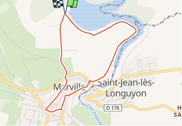
4.7 km | 6.1 km-effort
1h 23min
![](https://static1.geolcdn.com/siteimages/upload/files/16400158638029165_repeat_loop_refresh_sync_direction_icon.png)
No
![Walking Walking](https://static1.geolcdn.com/sitytour/trail-icons/101.png)
RB-Lu-18_Torgny
Walking
Very easy
Rouvroy,
Wallonia,
Luxembourg,
Belgium
![](/images/other/stat-length.png)
21 km | 28 km-effort
5h 54min
![](https://static1.geolcdn.com/siteimages/upload/files/16400158638029165_repeat_loop_refresh_sync_direction_icon.png)
Yes
![Trail Horseback riding Charency-Vezin - 2ème jour chez Juliette - Photo](https://media.geolcdn.com/t/375/260/9453c4a6-4d7a-49a5-95f3-427c78a3db79.jpg&format=jpg&maxdim=2)
![Horseback riding Horseback riding](https://static1.geolcdn.com/sitytour/trail-icons/301.png)
2ème jour chez Juliette
Horseback riding
Easy
Charency-Vezin,
Grand Est,
Meurthe-et-Moselle,
France
![](/images/other/stat-length.png)
9 km | 11.9 km-effort
1h 34min
![](https://static1.geolcdn.com/siteimages/upload/files/16400158638029165_repeat_loop_refresh_sync_direction_icon.png)
Yes
![Trail Walking Marville - Marville étang 14 km - Photo](https://media.geolcdn.com/t/375/260/103e8bcd-3886-413d-bcbd-c7abe01f9e01.jpg&format=jpg&maxdim=2)
![Walking Walking](https://static1.geolcdn.com/sitytour/trail-icons/101.png)
Marville étang 14 km
Walking
Easy
Marville,
Grand Est,
Meuse,
France
![](/images/other/stat-length.png)
14.1 km | 17.8 km-effort
4h 53min
![](https://static1.geolcdn.com/siteimages/upload/files/16400158638029165_repeat_loop_refresh_sync_direction_icon.png)
Yes
![Trail Walking Marville - Marville 17 km - Photo](https://media.geolcdn.com/t/375/260/50893f0f-10d5-476b-a0df-2030a890c462.jpg&format=jpg&maxdim=2)
![Walking Walking](https://static1.geolcdn.com/sitytour/trail-icons/101.png)
![Trail Walking Marville - Marville 18 km - Photo](https://media.geolcdn.com/t/375/260/ext.jpg?maxdim=2&url=https%3A%2F%2Fservices.sitytrail.com%2FGeolivesWS%2FDownloadMedia.ashx%3FTrailID%3D987549%26Media%3D20180616151046.jpg)
![Walking Walking](https://static1.geolcdn.com/sitytour/trail-icons/101.png)
RB-Lu-18_Torgny_via-racc-1
Walking
Very easy
Rouvroy,
Wallonia,
Luxembourg,
Belgium
![](/images/other/stat-length.png)
12.8 km | 17.2 km-effort
3h 33min
![](https://static1.geolcdn.com/siteimages/upload/files/16400158638029165_repeat_loop_refresh_sync_direction_icon.png)
Yes
![Trail Horseback riding Charency-Vezin - Charency Vezin chez Juliette pour ses 30 ans - Photo](https://media.geolcdn.com/t/375/260/f6d7a271-9a1e-44eb-8ed3-61209ec48f19.jpg&format=jpg&maxdim=2)
![Horseback riding Horseback riding](https://static1.geolcdn.com/sitytour/trail-icons/301.png)
Charency Vezin chez Juliette pour ses 30 ans
Horseback riding
Difficult
Charency-Vezin,
Grand Est,
Meurthe-et-Moselle,
France
![](/images/other/stat-length.png)
26 km | 33 km-effort
4h 21min
![](https://static1.geolcdn.com/siteimages/upload/files/16400158638029165_repeat_loop_refresh_sync_direction_icon.png)
Yes
![Trail Walking Othe - Othe - Photo](https://media.geolcdn.com/t/375/260/e3818b24-08f2-4632-a7a2-2a69d2499827.jpg&format=jpg&maxdim=2)
![Walking Walking](https://static1.geolcdn.com/sitytour/trail-icons/101.png)
Othe
Walking
Very difficult
Othe,
Grand Est,
Meurthe-et-Moselle,
France
![](/images/other/stat-length.png)
19.4 km | 24 km-effort
5h 52min
![](https://static1.geolcdn.com/siteimages/upload/files/16400158638029165_repeat_loop_refresh_sync_direction_icon.png)
Yes