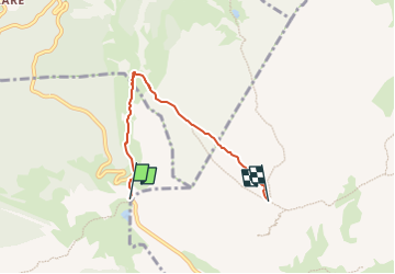
![](/images/other/stat-length.png)
![Trail On foot Livinallongo del Col di Lana - IT-20A - Photo](https://media.geolcdn.com/t/1900/400/23df5b89-0f3a-4afd-96e1-8bde0ea35087.jpeg&format=pjpeg&maxdim=2)
IT-20A
SityTrail - itinéraires balisés pédestres
Tous les sentiers balisés d’Europe GUIDE+
![Length](/images/other/stat-length.png)
Length
4.2 km
![Max alt](https://static1.geolcdn.com/siteimages/upload/files/1508320355ic_sort_altitude_max_24dp.png)
Max alt
2552 m
![Uphill gradient](https://static1.geolcdn.com/siteimages/upload/files/1508320355ic_sort_den_pos_24dp.png)
Uphill gradient
448 m
![Km-Effort](/images/other/stat-length.png)
Km-Effort
8.9 km
![Min alt](https://static1.geolcdn.com/siteimages/upload/files/1508320355ic_sort_altitude_min_24dp.png)
Min alt
2100 m
![Downhill gradient](https://static1.geolcdn.com/siteimages/upload/files/1508320355ic_sort_den_neg_24dp.png)
Downhill gradient
65 m
![Boucle](https://static1.geolcdn.com/siteimages/upload/files/16400158638029165_repeat_loop_refresh_sync_direction_icon.png)
Boucle
No
Signpost
Creation date :
2022-02-14 23:02:49.737
Updated on :
2022-02-28 17:01:55.036
![On foot](https://static1.geolcdn.com/sitytour/trail-icons/100.png)
2h01
Difficulty : Easy
![Scan this QR Code to open this trail in the SityTrail application](https://capi.geolives.com/qq0zvz2zws4bq2lad0pu/sitytour/trails/3112314/qr.png?size=200)
FREE GPS app for hiking
About
Trail On foot of 4.2 km to be discovered at Veneto, Belluno, Livinallongo del Col di Lana. This trail is proposed by SityTrail - itinéraires balisés pédestres.
Description
Trail created by C.A.I..
Positioning
Country:
Italy
Region :
Veneto
Department/Province :
Belluno
Municipality :
Livinallongo del Col di Lana
Location:
Unknown
Start:(Dec)
Start:(UTM)
729181 ; 5157471 (32T) N.
Comments
Trails nearby
![Trail On foot Cortina d'Ampezzo - 403 - Photo](https://media.geolcdn.com/t/375/260/e7a83c3c-599b-4c26-80e4-b96ec23a2e5a.jpeg&format=jpg&maxdim=2)
![On foot On foot](https://static1.geolcdn.com/sitytour/trail-icons/100.png)
![Trail On foot Cortina d'Ampezzo - (SI B04) Forcella Travenanzes (Bivio Lagazuoi) - Albergo Rifugio Ospitale - Photo](https://media.geolcdn.com/t/375/260/807c89f7-3651-49c4-a169-3e5c5dabc61a.jpeg&format=jpg&maxdim=2)
![On foot On foot](https://static1.geolcdn.com/sitytour/trail-icons/100.png)
(SI B04) Forcella Travenanzes (Bivio Lagazuoi) - Albergo Rifugio Ospitale
On foot
Medium
Cortina d'Ampezzo,
Veneto,
Belluno,
Italy
![](/images/other/stat-length.png)
16 km | 23 km-effort
5h 13min
![](https://static1.geolcdn.com/siteimages/upload/files/16400158638029165_repeat_loop_refresh_sync_direction_icon.png)
No
![Trail On foot Livinallongo del Col di Lana - IT-24 - Photo](https://media.geolcdn.com/t/375/260/cbccd70f-0a82-410f-9410-491e2acdf170.jpeg&format=jpg&maxdim=2)
![On foot On foot](https://static1.geolcdn.com/sitytour/trail-icons/100.png)
IT-24
On foot
Easy
Livinallongo del Col di Lana,
Veneto,
Belluno,
Italy
![](/images/other/stat-length.png)
5.7 km | 11.2 km-effort
2h 32min
![](https://static1.geolcdn.com/siteimages/upload/files/16400158638029165_repeat_loop_refresh_sync_direction_icon.png)
No
![Trail On foot Cortina d'Ampezzo - IT-424 - Photo](https://media.geolcdn.com/t/375/260/3ac0fb9f-8001-4b96-b838-ad9c3c46c7d5.jpeg&format=jpg&maxdim=2)
![On foot On foot](https://static1.geolcdn.com/sitytour/trail-icons/100.png)
![Trail On foot Cortina d'Ampezzo - IT-441 - Photo](https://media.geolcdn.com/t/375/260/801a35dc-07c8-497e-9fca-c5a6b78bfc3e.jpeg&format=jpg&maxdim=2)
![On foot On foot](https://static1.geolcdn.com/sitytour/trail-icons/100.png)
![Trail On foot Cortina d'Ampezzo - IT-412 - Photo](https://media.geolcdn.com/t/375/260/a25f4ac4-41bc-4fef-8c1c-419f6d0ff615.jpeg&format=jpg&maxdim=2)
![On foot On foot](https://static1.geolcdn.com/sitytour/trail-icons/100.png)
![Trail On foot Badia - Abtei - IT-20 - Photo](https://media.geolcdn.com/t/375/260/d0d67ee4-763d-459f-a010-81b4594b5a94.jpeg&format=jpg&maxdim=2)
![On foot On foot](https://static1.geolcdn.com/sitytour/trail-icons/100.png)
IT-20
On foot
Easy
Badia - Abtei,
Trentino-Alto Adige/Südtirol,
South Tyrol,
Italy
![](/images/other/stat-length.png)
6.2 km | 16.4 km-effort
3h 44min
![](https://static1.geolcdn.com/siteimages/upload/files/16400158638029165_repeat_loop_refresh_sync_direction_icon.png)
No
![Trail On foot Cortina d'Ampezzo - IT-401 - Photo](https://media.geolcdn.com/t/375/260/72f179c1-0f91-40b3-89ed-82a2331b9ecc.jpeg&format=jpg&maxdim=2)
![On foot On foot](https://static1.geolcdn.com/sitytour/trail-icons/100.png)
![Trail On foot Cortina d'Ampezzo - IT-402 - Photo](https://media.geolcdn.com/t/375/260/9be3dbca-1e98-441d-84ee-4f19b9e96f84.jpeg&format=jpg&maxdim=2)
![On foot On foot](https://static1.geolcdn.com/sitytour/trail-icons/100.png)