![](/images/other/stat-length.png)
![Trail On foot Duino Aurisina / Devin - Nabrežina - IT-33 - Photo](https://media.geolcdn.com/t/1900/400/2d34aeb8-5efc-45f7-8854-f85fa01accb4.jpeg&format=pjpeg&maxdim=2)
IT-33
SityTrail - itinéraires balisés pédestres
Tous les sentiers balisés d’Europe GUIDE+
![Length](/images/other/stat-length.png)
![Max alt](https://static1.geolcdn.com/siteimages/upload/files/1508320355ic_sort_altitude_max_24dp.png)
![Uphill gradient](https://static1.geolcdn.com/siteimages/upload/files/1508320355ic_sort_den_pos_24dp.png)
![Km-Effort](/images/other/stat-length.png)
![Min alt](https://static1.geolcdn.com/siteimages/upload/files/1508320355ic_sort_altitude_min_24dp.png)
![Downhill gradient](https://static1.geolcdn.com/siteimages/upload/files/1508320355ic_sort_den_neg_24dp.png)
![Boucle](https://static1.geolcdn.com/siteimages/upload/files/16400158638029165_repeat_loop_refresh_sync_direction_icon.png)
![On foot](https://static1.geolcdn.com/sitytour/trail-icons/100.png)
2h28
Difficulty : Easy
![Scan this QR Code to open this trail in the SityTrail application](https://capi.geolives.com/qq0zvz2zws4bq2lad0pu/sitytour/trails/3112205/qr.png?size=200)
FREE GPS app for hiking
About
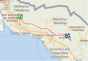
Trail On foot of 8 km to be discovered at Friuli Venezia Giulia, Unknown, Duino Aurisina / Devin - Nabrežina. This trail is proposed by SityTrail - itinéraires balisés pédestres.
Description
Trail created by Commissione Giulio Carnica Sentieri, Rifugi e Opere Alpine.
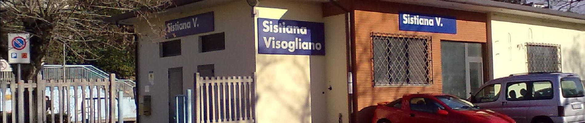
Grotta del Mitreo (bivio sentiero n. 1A) - Visogliano - Slivia - Grotta Lindner (bivio sentiero n. 32)
Symbol: 33 on white red flag
Website: http://www.cai-fvg.it/sentieri-cai-fvg/sentieri-cai-fvg-settore-0-carso/
Positioning
Comments
Trails nearby
![Trail On foot Monfalcone - Sentiero CAI n. 83 - Photo](https://media.geolcdn.com/t/375/260/557de7c4-69bc-42ad-b0e2-c4cabedb9143.jpeg&format=jpg&maxdim=2)
![On foot On foot](https://static1.geolcdn.com/sitytour/trail-icons/100.png)
On foot
![](/images/other/stat-length.png)
![](https://static1.geolcdn.com/siteimages/upload/files/16400158638029165_repeat_loop_refresh_sync_direction_icon.png)
![Trail On foot Duino Aurisina / Devin - Nabrežina - IT-8 - Photo](https://media.geolcdn.com/t/375/260/f4b67a2d-0528-49d6-bb22-fdab9bcf8f38.jpeg&format=jpg&maxdim=2)
![On foot On foot](https://static1.geolcdn.com/sitytour/trail-icons/100.png)
On foot
![](/images/other/stat-length.png)
![](https://static1.geolcdn.com/siteimages/upload/files/16400158638029165_repeat_loop_refresh_sync_direction_icon.png)
![Trail On foot Doberdò del Lago / Doberdob - Sentiero CAI n. 72 - Photo](https://media.geolcdn.com/t/375/260/49432fad-513b-42f1-bd91-4760c9c7cc82.jpeg&format=jpg&maxdim=2)
![On foot On foot](https://static1.geolcdn.com/sitytour/trail-icons/100.png)
On foot
![](/images/other/stat-length.png)
![](https://static1.geolcdn.com/siteimages/upload/files/16400158638029165_repeat_loop_refresh_sync_direction_icon.png)
![Trail On foot Duino Aurisina / Devin - Nabrežina - Gemina - Karst Countryside Ways - Photo](https://media.geolcdn.com/t/375/260/a10631fd-0b10-4193-a87a-cf1380683084.jpeg&format=jpg&maxdim=2)
![On foot On foot](https://static1.geolcdn.com/sitytour/trail-icons/100.png)
On foot
![](/images/other/stat-length.png)
![](https://static1.geolcdn.com/siteimages/upload/files/16400158638029165_repeat_loop_refresh_sync_direction_icon.png)
![Trail On foot Duino Aurisina / Devin - Nabrežina - Učna pot Nabrežina / Percorso didattico Aurisina - Photo](https://media.geolcdn.com/t/375/260/c59f5fd2-1bda-4cac-ad99-20a79c07a567.jpeg&format=jpg&maxdim=2)
![On foot On foot](https://static1.geolcdn.com/sitytour/trail-icons/100.png)
On foot
![](/images/other/stat-length.png)
![](https://static1.geolcdn.com/siteimages/upload/files/16400158638029165_repeat_loop_refresh_sync_direction_icon.png)
![Trail On foot Duino Aurisina / Devin - Nabrežina - (SI A24) Malchina - Repen - Photo](https://media.geolcdn.com/t/375/260/ext.jpg?maxdim=2&url=https%3A%2F%2Fstatic1.geolcdn.com%2Fsiteimages%2Fupload%2Ffiles%2F1545311037marcheuse_200dpi.jpg)
![On foot On foot](https://static1.geolcdn.com/sitytour/trail-icons/100.png)
On foot
![](/images/other/stat-length.png)
![](https://static1.geolcdn.com/siteimages/upload/files/16400158638029165_repeat_loop_refresh_sync_direction_icon.png)