![](/images/other/stat-length.png)
![Trail On foot Trento - Sentiero Trento Nostra - Photo](https://media.geolcdn.com/t/1900/400/7fcb14f3-7acc-448c-a395-d53747198239.jpeg&format=pjpeg&maxdim=2)
Sentiero Trento Nostra
SityTrail - itinéraires balisés pédestres
Tous les sentiers balisés d’Europe GUIDE+
![Length](/images/other/stat-length.png)
Length
6.1 km
![Max alt](https://static1.geolcdn.com/siteimages/upload/files/1508320355ic_sort_altitude_max_24dp.png)
Max alt
1279 m
![Uphill gradient](https://static1.geolcdn.com/siteimages/upload/files/1508320355ic_sort_den_pos_24dp.png)
Uphill gradient
1060 m
![Km-Effort](/images/other/stat-length.png)
Km-Effort
16.7 km
![Min alt](https://static1.geolcdn.com/siteimages/upload/files/1508320355ic_sort_altitude_min_24dp.png)
Min alt
208 m
![Downhill gradient](https://static1.geolcdn.com/siteimages/upload/files/1508320355ic_sort_den_neg_24dp.png)
Downhill gradient
1 m
![Boucle](https://static1.geolcdn.com/siteimages/upload/files/16400158638029165_repeat_loop_refresh_sync_direction_icon.png)
Boucle
No
Signpost
Creation date :
2022-02-14 21:57:50.435
Updated on :
2022-02-28 14:26:43.718
![On foot](https://static1.geolcdn.com/sitytour/trail-icons/100.png)
3h47
Difficulty : Easy
![Scan this QR Code to open this trail in the SityTrail application](https://capi.geolives.com/qq0zvz2zws4bq2lad0pu/sitytour/trails/3111788/qr.png?size=200)
FREE GPS app for hiking
About
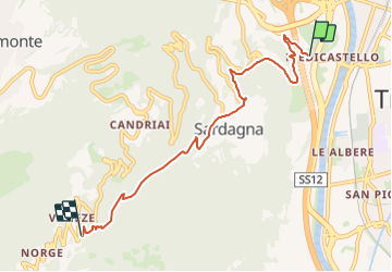
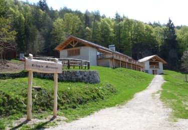
Trail On foot of 6.1 km to be discovered at Trentino-Alto Adige/Südtirol, Provincia di Trento, Trento. This trail is proposed by SityTrail - itinéraires balisés pédestres.
Description
Trail created by Società degli Alpinisti Tridentini.
Website: http://www.sat.tn.it/
Positioning
Country:
Italy
Region :
Trentino-Alto Adige/Südtirol
Department/Province :
Provincia di Trento
Municipality :
Trento
Location:
Unknown
Start:(Dec)
Start:(UTM)
663132 ; 5104108 (32T) N.
Comments
Trails nearby
![Trail On foot Trento - IT-O625 - Photo](https://media.geolcdn.com/t/375/260/eb769a9f-392e-48c5-a4df-c82e4dc5026a.jpeg&format=jpg&maxdim=2)
![On foot On foot](https://static1.geolcdn.com/sitytour/trail-icons/100.png)
IT-O625
On foot
Easy
Trento,
Trentino-Alto Adige/Südtirol,
Provincia di Trento,
Italy
![](/images/other/stat-length.png)
3.1 km | 5.2 km-effort
1h 10min
![](https://static1.geolcdn.com/siteimages/upload/files/16400158638029165_repeat_loop_refresh_sync_direction_icon.png)
No
![Trail On foot Trento - IT-O621 - Photo](https://media.geolcdn.com/t/375/260/a16b9625-ca76-4fdd-864d-341b3e23f7bd.jpeg&format=jpg&maxdim=2)
![On foot On foot](https://static1.geolcdn.com/sitytour/trail-icons/100.png)
IT-O621
On foot
Easy
Trento,
Trentino-Alto Adige/Südtirol,
Provincia di Trento,
Italy
![](/images/other/stat-length.png)
7.8 km | 17.3 km-effort
3h 56min
![](https://static1.geolcdn.com/siteimages/upload/files/16400158638029165_repeat_loop_refresh_sync_direction_icon.png)
No
![Trail On foot Vallelaghi - IT-O611 - Photo](https://media.geolcdn.com/t/375/260/d54ab7e1-0720-450b-8f77-e904900776ad.jpeg&format=jpg&maxdim=2)
![On foot On foot](https://static1.geolcdn.com/sitytour/trail-icons/100.png)
IT-O611
On foot
Easy
Vallelaghi,
Trentino-Alto Adige/Südtirol,
Provincia di Trento,
Italy
![](/images/other/stat-length.png)
4.5 km | 8.2 km-effort
1h 52min
![](https://static1.geolcdn.com/siteimages/upload/files/16400158638029165_repeat_loop_refresh_sync_direction_icon.png)
No
![Trail On foot Civezzano - IT-15 - Photo](https://media.geolcdn.com/t/375/260/b378030a-901e-4b4a-b3a9-13ae7cd89dfc.jpeg&format=jpg&maxdim=2)
![On foot On foot](https://static1.geolcdn.com/sitytour/trail-icons/100.png)
IT-15
On foot
Easy
Civezzano,
Trentino-Alto Adige/Südtirol,
Provincia di Trento,
Italy
![](/images/other/stat-length.png)
5.4 km | 8.5 km-effort
1h 56min
![](https://static1.geolcdn.com/siteimages/upload/files/16400158638029165_repeat_loop_refresh_sync_direction_icon.png)
No
![Trail On foot Trento - IT-2 - Photo](https://media.geolcdn.com/t/375/260/971eb05b-e3b2-4d87-9b31-c56c26e1ac62.jpeg&format=jpg&maxdim=2)
![On foot On foot](https://static1.geolcdn.com/sitytour/trail-icons/100.png)
IT-2
On foot
Easy
Trento,
Trentino-Alto Adige/Südtirol,
Provincia di Trento,
Italy
![](/images/other/stat-length.png)
9.2 km | 16.7 km-effort
3h 47min
![](https://static1.geolcdn.com/siteimages/upload/files/16400158638029165_repeat_loop_refresh_sync_direction_icon.png)
No
![Trail On foot Trento - IT-E429 - Photo](https://media.geolcdn.com/t/375/260/27647e1e-e7d2-40f3-a4e1-245b1c15c33e.jpeg&format=jpg&maxdim=2)
![On foot On foot](https://static1.geolcdn.com/sitytour/trail-icons/100.png)
IT-E429
On foot
Easy
Trento,
Trentino-Alto Adige/Südtirol,
Provincia di Trento,
Italy
![](/images/other/stat-length.png)
4.7 km | 6 km-effort
1h 21min
![](https://static1.geolcdn.com/siteimages/upload/files/16400158638029165_repeat_loop_refresh_sync_direction_icon.png)
No
![Trail On foot Trento - Senter delle pegore - Photo](https://media.geolcdn.com/t/375/260/63c5f835-fa81-4c46-bac0-6d85c7cf55c7.jpeg&format=jpg&maxdim=2)
![On foot On foot](https://static1.geolcdn.com/sitytour/trail-icons/100.png)
Senter delle pegore
On foot
Easy
Trento,
Trentino-Alto Adige/Südtirol,
Provincia di Trento,
Italy
![](/images/other/stat-length.png)
3.2 km | 5.9 km-effort
1h 20min
![](https://static1.geolcdn.com/siteimages/upload/files/16400158638029165_repeat_loop_refresh_sync_direction_icon.png)
No
![Trail On foot Trento - IT-E411 - Photo](https://media.geolcdn.com/t/375/260/d978ba94-d05b-4372-9695-3d9f35e54646.jpeg&format=jpg&maxdim=2)
![On foot On foot](https://static1.geolcdn.com/sitytour/trail-icons/100.png)
IT-E411
On foot
Medium
Trento,
Trentino-Alto Adige/Südtirol,
Provincia di Trento,
Italy
![](/images/other/stat-length.png)
7.7 km | 20 km-effort
4h 37min
![](https://static1.geolcdn.com/siteimages/upload/files/16400158638029165_repeat_loop_refresh_sync_direction_icon.png)
No
![Trail On foot Trento - Sentiero di San Vili - Photo](https://media.geolcdn.com/t/375/260/85008208-58eb-4a3c-bc59-b9eb49eba440.jpeg&format=jpg&maxdim=2)
![On foot On foot](https://static1.geolcdn.com/sitytour/trail-icons/100.png)
Sentiero di San Vili
On foot
Medium
Trento,
Trentino-Alto Adige/Südtirol,
Provincia di Trento,
Italy
![](/images/other/stat-length.png)
18.1 km | 30 km-effort
6h 52min
![](https://static1.geolcdn.com/siteimages/upload/files/16400158638029165_repeat_loop_refresh_sync_direction_icon.png)
No