![](/images/other/stat-length.png)
![Trail On foot Lecco - Sentiero 21: Erna - Artavaggio - Photo](https://media.geolcdn.com/t/1900/400/316d5b51-7c63-49ef-b75b-c49157a4c054.jpeg&format=pjpeg&maxdim=2)
Sentiero 21: Erna - Artavaggio
SityTrail - itinéraires balisés pédestres
Tous les sentiers balisés d’Europe GUIDE+
![Length](/images/other/stat-length.png)
![Max alt](https://static1.geolcdn.com/siteimages/upload/files/1508320355ic_sort_altitude_max_24dp.png)
![Uphill gradient](https://static1.geolcdn.com/siteimages/upload/files/1508320355ic_sort_den_pos_24dp.png)
![Km-Effort](/images/other/stat-length.png)
![Min alt](https://static1.geolcdn.com/siteimages/upload/files/1508320355ic_sort_altitude_min_24dp.png)
![Downhill gradient](https://static1.geolcdn.com/siteimages/upload/files/1508320355ic_sort_den_neg_24dp.png)
![Boucle](https://static1.geolcdn.com/siteimages/upload/files/16400158638029165_repeat_loop_refresh_sync_direction_icon.png)
![On foot](https://static1.geolcdn.com/sitytour/trail-icons/100.png)
6h05
Difficulty : Medium
![Scan this QR Code to open this trail in the SityTrail application](https://capi.geolives.com/qq0zvz2zws4bq2lad0pu/sitytour/trails/3111671/qr.png?size=200)
FREE GPS app for hiking
About
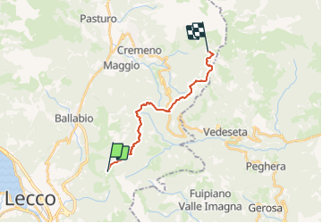
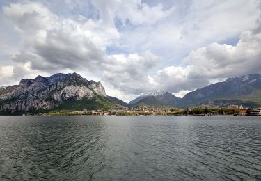
Trail On foot of 14.9 km to be discovered at Lombardy, Lecco, Lecco. This trail is proposed by SityTrail - itinéraires balisés pédestres.
Description
Trail created by Società Escursionisti Lecchesi.
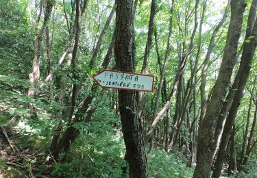
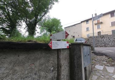
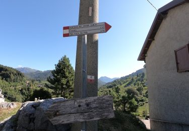
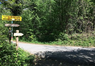
Symbol: depends on trail section: blazes red-white-yellow vertical stripes with black text "21" (Forcella di Olino-Artavatggio); wooden markers (white text "21") or reddish square paint blazes (sometimes with black text "21") on trees ( Erna - Forcella di Olino)
Website: https://rifugiomarchett.webnode.it/escursioni/
Positioning
Comments
Trails nearby
![Trail On foot Brumano - Sentiero 587: Brumano - Colletto di Brumano - Photo](https://media.geolcdn.com/t/375/260/d5220cad-47dc-402e-9f38-155ebf4f6518.jpeg&format=jpg&maxdim=2)
![On foot On foot](https://static1.geolcdn.com/sitytour/trail-icons/100.png)
On foot
![](/images/other/stat-length.png)
![](https://static1.geolcdn.com/siteimages/upload/files/16400158638029165_repeat_loop_refresh_sync_direction_icon.png)
![Trail On foot Rota d'Imagna - Sentiero 586: Rota d'Imagna - La Passata - Photo](https://media.geolcdn.com/t/375/260/6d394a27-a7f0-49ed-aec2-91bbd9475b1b.jpeg&format=jpg&maxdim=2)
![On foot On foot](https://static1.geolcdn.com/sitytour/trail-icons/100.png)
On foot
![](/images/other/stat-length.png)
![](https://static1.geolcdn.com/siteimages/upload/files/16400158638029165_repeat_loop_refresh_sync_direction_icon.png)
![Trail On foot Brumano - Sentiero 576: Brumano - Passo La Porta - La Passata - Photo](https://media.geolcdn.com/t/375/260/4eeb1c59-5b44-4f1b-a83f-dd9e672cf940.jpeg&format=jpg&maxdim=2)
![On foot On foot](https://static1.geolcdn.com/sitytour/trail-icons/100.png)
On foot
![](/images/other/stat-length.png)
![](https://static1.geolcdn.com/siteimages/upload/files/16400158638029165_repeat_loop_refresh_sync_direction_icon.png)
![Trail On foot Erve - Variante per Prá di Rat - Photo](https://media.geolcdn.com/t/375/260/b3ff494c-2581-4b0a-a6cd-25ad3d352528.jpeg&format=jpg&maxdim=2)
![On foot On foot](https://static1.geolcdn.com/sitytour/trail-icons/100.png)
On foot
![](/images/other/stat-length.png)
![](https://static1.geolcdn.com/siteimages/upload/files/16400158638029165_repeat_loop_refresh_sync_direction_icon.png)
![Trail On foot Morterone - Sentiero dei Grandi Alberi - anello principale - Photo](https://media.geolcdn.com/t/375/260/b0ae6341-4f3f-457a-9fa7-59eb2b1b7750.jpeg&format=jpg&maxdim=2)
![On foot On foot](https://static1.geolcdn.com/sitytour/trail-icons/100.png)
On foot
![](/images/other/stat-length.png)
![](https://static1.geolcdn.com/siteimages/upload/files/16400158638029165_repeat_loop_refresh_sync_direction_icon.png)
![Trail On foot Morterone - Sentiero dei Grandi Alberi - Photo](https://media.geolcdn.com/t/375/260/b0ae6341-4f3f-457a-9fa7-59eb2b1b7750.jpeg&format=jpg&maxdim=2)
![On foot On foot](https://static1.geolcdn.com/sitytour/trail-icons/100.png)
On foot
![](/images/other/stat-length.png)
![](https://static1.geolcdn.com/siteimages/upload/files/16400158638029165_repeat_loop_refresh_sync_direction_icon.png)
![Trail On foot Lecco - Sentiero 2 della Val Calolden - Photo](https://media.geolcdn.com/t/375/260/6a9d73e2-be77-4099-a255-f8b347ac14ac.jpeg&format=jpg&maxdim=2)
![On foot On foot](https://static1.geolcdn.com/sitytour/trail-icons/100.png)
On foot
![](/images/other/stat-length.png)
![](https://static1.geolcdn.com/siteimages/upload/files/16400158638029165_repeat_loop_refresh_sync_direction_icon.png)
![Trail On foot Lecco - Percorso Giorgio Combi - Photo](https://media.geolcdn.com/t/375/260/48ecfc1f-868d-4b17-879f-6b7b4f7605e2.jpeg&format=jpg&maxdim=2)
![On foot On foot](https://static1.geolcdn.com/sitytour/trail-icons/100.png)
![Trail On foot Lecco - Sentiero 18 (della Corna Cammello): Versasio - Piani d'Erna - Photo](https://media.geolcdn.com/t/375/260/8ce93a6f-64ae-432f-a2ee-6859572d3ed1.jpeg&format=jpg&maxdim=2)
![On foot On foot](https://static1.geolcdn.com/sitytour/trail-icons/100.png)
On foot
![](/images/other/stat-length.png)
![](https://static1.geolcdn.com/siteimages/upload/files/16400158638029165_repeat_loop_refresh_sync_direction_icon.png)
text