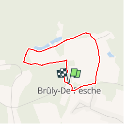
![](/images/other/stat-length.png)
![Trail Walking Couvin - (Couvin) 12 - Bas Brûly- Brûly-de-Pesche Walk - Photo](https://media.geolcdn.com/t/1900/400/ext.pjpeg?maxdim=2&url=https%3A%2F%2Fservices.sitytrail.com%2FGeolivesWS%2FDownloadMedia.ashx%3FTrailID%3D311124%26Media%3D445d3b7a-379f-42df-83f7-8b637f6974b0.jpg)
(Couvin) 12 - Bas Brûly- Brûly-de-Pesche Walk
La Forêt du Pays de Chimay
Randonnées au coeur d'une nature préservée GUIDE+
![Length](/images/other/stat-length.png)
![Max alt](https://static1.geolcdn.com/siteimages/upload/files/1508320355ic_sort_altitude_max_24dp.png)
![Uphill gradient](https://static1.geolcdn.com/siteimages/upload/files/1508320355ic_sort_den_pos_24dp.png)
![Km-Effort](/images/other/stat-length.png)
![Min alt](https://static1.geolcdn.com/siteimages/upload/files/1508320355ic_sort_altitude_min_24dp.png)
![Downhill gradient](https://static1.geolcdn.com/siteimages/upload/files/1508320355ic_sort_den_neg_24dp.png)
![Boucle](https://static1.geolcdn.com/siteimages/upload/files/16400158638029165_repeat_loop_refresh_sync_direction_icon.png)
![Walking](https://static1.geolcdn.com/sitytour/trail-icons/101.png)
49m
Difficulty : Medium
![Scan this QR Code to open this trail in the SityTrail application](https://capi.geolives.com/qq0zvz2zws4bq2lad0pu/sitytour/trails/311124/qr.png?size=200)
FREE GPS app for hiking
About
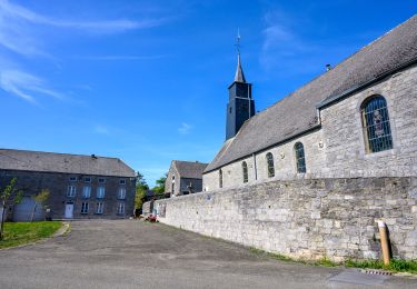
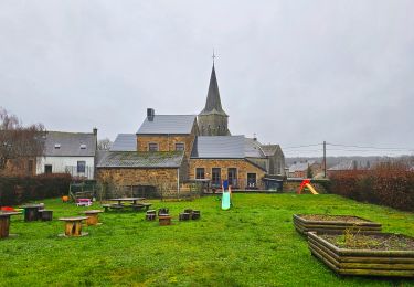
Trail Walking of 3 km to be discovered at Wallonia, Namur, Couvin. This trail is proposed by La Forêt du Pays de Chimay.
Description
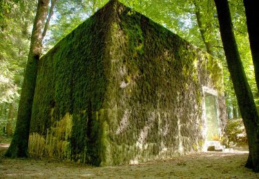
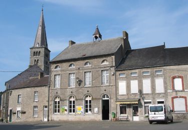
The starting point of the walk is a few metres from the site of Hitler's Bunker.
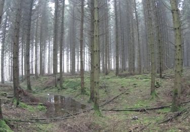
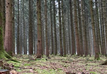
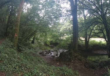
This itinerary will take you through woods and fields.
Trees and flora: many remarkable trees (beech, chestnut, large-leaved lime). Place Saint-Méen and Hitler's Bunker
Fauna: colony of jackdaws on the towers of Brûly-de-Pesche church screech owl in the bell towers
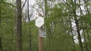
Positioning
Comments
Trails nearby
![Trail Walking Couvin - RB-Na-27_Entre Eau Blanche et Eau Noire - Photo](https://media.geolcdn.com/t/375/260/31d58e74-eca9-4391-a48f-1c05f2d409c1.jpg&format=jpg&maxdim=2)
![Walking Walking](https://static1.geolcdn.com/sitytour/trail-icons/101.png)
Walking
![](/images/other/stat-length.png)
![](https://static1.geolcdn.com/siteimages/upload/files/16400158638029165_repeat_loop_refresh_sync_direction_icon.png)
![Trail Walking Couvin - De Presgaux à Brûly-de-Pesche - Photo](https://media.geolcdn.com/t/375/260/ext.jpg?maxdim=2&url=https%3A%2F%2Fservices.sitytrail.com%2FGeolivesWS%2FDownloadMedia.ashx%3FTrailID%3D898028%26Media%3D6e8bfb5c-e225-4bdb-a6f3-69d09b53e823.jpg)
![Walking Walking](https://static1.geolcdn.com/sitytour/trail-icons/101.png)
Walking
![](/images/other/stat-length.png)
![](https://static1.geolcdn.com/siteimages/upload/files/16400158638029165_repeat_loop_refresh_sync_direction_icon.png)
![Trail Walking Couvin - (Couvin) 22 Promenade de l'Eau Noire - Photo](https://media.geolcdn.com/t/375/260/ext.jpg?maxdim=2&url=https%3A%2F%2Fstatic1.geolcdn.com%2Fsiteimages%2Fupload%2Ffiles%2F1553511878bg_sport_marche.png)
![Walking Walking](https://static1.geolcdn.com/sitytour/trail-icons/101.png)
Walking
![](/images/other/stat-length.png)
![](https://static1.geolcdn.com/siteimages/upload/files/16400158638029165_repeat_loop_refresh_sync_direction_icon.png)
![Trail Walking Couvin - (Couvin) 10 - Bois de Gonrieux (Gonrieux Wood) Walk - Photo](https://media.geolcdn.com/t/375/260/ext.jpg?maxdim=2&url=https%3A%2F%2Fservices.sitytrail.com%2FGeolivesWS%2FDownloadMedia.ashx%3FTrailID%3D311123%26Media%3Dbf57e957-32ed-48b8-b728-86a89c9c1927.jpg)
![Walking Walking](https://static1.geolcdn.com/sitytour/trail-icons/101.png)
Walking
![](/images/other/stat-length.png)
![](https://static1.geolcdn.com/siteimages/upload/files/16400158638029165_repeat_loop_refresh_sync_direction_icon.png)
![Trail Walking Couvin - Brûlures de peches - Photo](https://media.geolcdn.com/t/375/260/62dec7d8-1d84-4759-af77-767dca47913f.jpg&format=jpg&maxdim=2)
![Walking Walking](https://static1.geolcdn.com/sitytour/trail-icons/101.png)
![Trail Walking Couvin - Balade de Gonrieux à Presgaux - Photo](https://media.geolcdn.com/t/375/260/d101f14c-b0e3-40d3-986f-4fa86f2d65ee.jpeg&format=jpg&maxdim=2)
![Walking Walking](https://static1.geolcdn.com/sitytour/trail-icons/101.png)
Walking
![](/images/other/stat-length.png)
![](https://static1.geolcdn.com/siteimages/upload/files/16400158638029165_repeat_loop_refresh_sync_direction_icon.png)
![Trail On foot Couvin - Promenade d'Efer - Photo](https://media.geolcdn.com/t/375/260/65ce7672-d62e-4a99-8a50-e2bb7ccce2f9.jpeg&format=jpg&maxdim=2)
![On foot On foot](https://static1.geolcdn.com/sitytour/trail-icons/100.png)
![Mountain bike Mountain bike](https://static1.geolcdn.com/sitytour/trail-icons/202.png)
Mountain bike
![](/images/other/stat-length.png)
![](https://static1.geolcdn.com/siteimages/upload/files/16400158638029165_repeat_loop_refresh_sync_direction_icon.png)
![Trail Walking Couvin - Pesche - Presgaux - Gonrieux - Photo](https://media.geolcdn.com/t/375/260/ext.jpg?maxdim=2&url=https%3A%2F%2Fstatic1.geolcdn.com%2Fsiteimages%2Fupload%2Ffiles%2F1553511878bg_sport_marche.png)
![Walking Walking](https://static1.geolcdn.com/sitytour/trail-icons/101.png)
Walking
![](/images/other/stat-length.png)
![](https://static1.geolcdn.com/siteimages/upload/files/16400158638029165_repeat_loop_refresh_sync_direction_icon.png)