


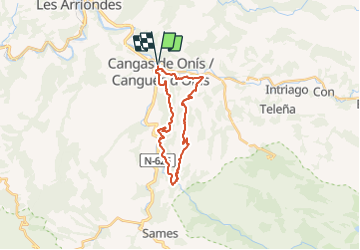

17.3 km | 26 km-effort
![Trail On foot Cangas de Onís - [TRC-002 R3] Ruta del Rey Pelayo - Photo](https://media.geolcdn.com/t/1900/400/f65b4fbb-0b71-47f6-9620-4d57c9854fa2.jpeg&format=pjpeg&maxdim=2)

Tous les sentiers balisés d’Europe GUIDE+


FREE GPS app for hiking
 SityTrail
IGN / Geographical institutes
SityTrail World
The world is yours!
Trail On foot of 24 km to be discovered at Asturias, Asturias, Cangas de Onís. This trail is proposed by SityTrail - itinéraires balisés pédestres.
Website: https://www.cangasdeonis.es/centro-permanente-de-trail-running
![Trail On foot Cangas de Onís - [TRC-002 R3] Ruta del Rey Pelayo - Photo 1](https://media.geolcdn.com/t/2048/auto/db355e92-a59c-4074-acfa-fbbd7c2bd915.jpeg&format=jpg&maxdim=0 "Trail On foot Cangas de Onís - [TRC-002 R3] Ruta del Rey Pelayo - Photo 1")
![Trail On foot Cangas de Onís - [TRC-002 R3] Ruta del Rey Pelayo - Photo 2](https://media.geolcdn.com/t/2048/auto/dc6bf941-2f5e-4aec-ba94-8cb431410e75.jpeg&format=jpg&maxdim=0 "Trail On foot Cangas de Onís - [TRC-002 R3] Ruta del Rey Pelayo - Photo 2")
![Trail On foot Cangas de Onís - [TRC-002 R3] Ruta del Rey Pelayo - Photo 3](https://media.geolcdn.com/t/2048/auto/3061ec99-469f-4168-8036-9b016ce9e33d.jpeg&format=jpg&maxdim=0 "Trail On foot Cangas de Onís - [TRC-002 R3] Ruta del Rey Pelayo - Photo 3")
![Trail On foot Cangas de Onís - [TRC-002 R3] Ruta del Rey Pelayo - Photo 4](https://media.geolcdn.com/t/2048/auto/1f0fd472-7a6b-4c8c-8c36-b5bd5597f427.jpeg&format=jpg&maxdim=0 "Trail On foot Cangas de Onís - [TRC-002 R3] Ruta del Rey Pelayo - Photo 4")
![Trail On foot Cangas de Onís - [TRC-002 R3] Ruta del Rey Pelayo - Photo 5](https://media.geolcdn.com/t/2048/auto/f0bd09c6-5931-4474-a6a1-3d8aee9ffc6c.jpeg&format=jpg&maxdim=0 "Trail On foot Cangas de Onís - [TRC-002 R3] Ruta del Rey Pelayo - Photo 5")
![Trail On foot Cangas de Onís - [TRC-002 R3] Ruta del Rey Pelayo - Photo 6](https://media.geolcdn.com/t/2048/auto/59dcaa65-3c41-4580-ab3f-648f69eecbd0.jpeg&format=jpg&maxdim=0 "Trail On foot Cangas de Onís - [TRC-002 R3] Ruta del Rey Pelayo - Photo 6")
![Trail On foot Cangas de Onís - [TRC-002 R3] Ruta del Rey Pelayo - Photo 7](https://media.geolcdn.com/t/2048/auto/fe4f4fa9-1180-4cee-b460-fccf4dcdaf00.jpeg&format=jpg&maxdim=0 "Trail On foot Cangas de Onís - [TRC-002 R3] Ruta del Rey Pelayo - Photo 7")
![Trail On foot Cangas de Onís - [TRC-002 R3] Ruta del Rey Pelayo - Photo 8](https://media.geolcdn.com/t/2048/auto/92e20d5d-462a-425d-aa1c-75c8be01e2e4.jpeg&format=jpg&maxdim=0 "Trail On foot Cangas de Onís - [TRC-002 R3] Ruta del Rey Pelayo - Photo 8")
![Trail On foot Cangas de Onís - [TRC-002 R3] Ruta del Rey Pelayo - Photo 9](https://media.geolcdn.com/t/2048/auto/0ebdad59-fbdf-4f29-9a19-03b092f881e7.jpeg&format=jpg&maxdim=0 "Trail On foot Cangas de Onís - [TRC-002 R3] Ruta del Rey Pelayo - Photo 9")
![Trail On foot Cangas de Onís - [TRC-002 R3] Ruta del Rey Pelayo - Photo 10](https://media.geolcdn.com/t/2048/auto/f65b4fbb-0b71-47f6-9620-4d57c9854fa2.jpeg&format=jpg&maxdim=0 "Trail On foot Cangas de Onís - [TRC-002 R3] Ruta del Rey Pelayo - Photo 10")
![Trail On foot Cangas de Onís - [TRC-002 R2] Ruta del Rey Favila - Photo](https://media.geolcdn.com/t/375/260/ba158dcb-dfe0-4b5b-a168-1a9b2d3f986a.jpeg&format=jpg&maxdim=2)
On foot
![Trail On foot Cangas de Onís - [TRC-002 R1] Ruta del Puentón - Photo](https://media.geolcdn.com/t/375/260/1f0fd472-7a6b-4c8c-8c36-b5bd5597f427.jpeg&format=jpg&maxdim=2)
On foot

Walking