


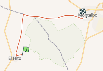
SL-CU 01 Laguna del Hito

SityTrail - itinéraires balisés pédestres
Tous les sentiers balisés d’Europe GUIDE+

Length
5.9 km

Max alt
891 m

Uphill gradient
92 m
Km-Effort
7 km

Min alt
829 m

Downhill gradient
57 m
Boucle
No

Signpost
Creation date :
2022-02-14 15:50:26.817
Updated on :
2022-02-14 15:50:26.817
1h35
Difficulty : Easy

FREE GPS app for hiking
 SityTrail
IGN / Geographical institutes
SityTrail World
The world is yours!
About
Trail On foot of 5.9 km to be discovered at Castile-La Mancha, Cuenca, El Hito. This trail is proposed by SityTrail - itinéraires balisés pédestres.
Positioning
Country:
Spain
Region :
Castile-La Mancha
Department/Province :
Cuenca
Municipality :
El Hito
Location:
Unknown
Start:(Dec)
Start:(UTM)
524769 ; 4412278 (30S) N.
Comments
Trails nearby