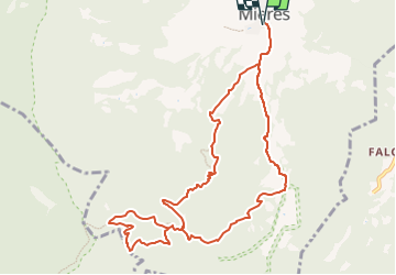
![](/images/other/stat-length.png)
![Trail On foot Mieres - Ruta dels carboners i el bac - Photo](https://media.geolcdn.com/t/1900/400/290ea93a-3def-4142-b339-4b864a71c8d5.jpeg&format=pjpeg&maxdim=2)
Ruta dels carboners i el bac
SityTrail - itinéraires balisés pédestres
Tous les sentiers balisés d’Europe GUIDE+
![Length](/images/other/stat-length.png)
![Max alt](https://static1.geolcdn.com/siteimages/upload/files/1508320355ic_sort_altitude_max_24dp.png)
![Uphill gradient](https://static1.geolcdn.com/siteimages/upload/files/1508320355ic_sort_den_pos_24dp.png)
![Km-Effort](/images/other/stat-length.png)
![Min alt](https://static1.geolcdn.com/siteimages/upload/files/1508320355ic_sort_altitude_min_24dp.png)
![Downhill gradient](https://static1.geolcdn.com/siteimages/upload/files/1508320355ic_sort_den_neg_24dp.png)
![Boucle](https://static1.geolcdn.com/siteimages/upload/files/16400158638029165_repeat_loop_refresh_sync_direction_icon.png)
![On foot](https://static1.geolcdn.com/sitytour/trail-icons/100.png)
4h21
Difficulty : Easy
![Scan this QR Code to open this trail in the SityTrail application](https://capi.geolives.com/qq0zvz2zws4bq2lad0pu/sitytour/trails/3110566/qr.png?size=200)
FREE GPS app for hiking
About
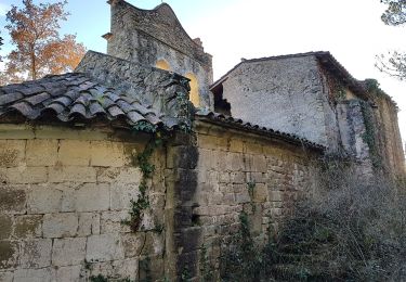
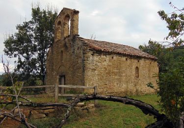
Trail On foot of 11.7 km to be discovered at Catalonia, Girona, Mieres. This trail is proposed by SityTrail - itinéraires balisés pédestres.
Description
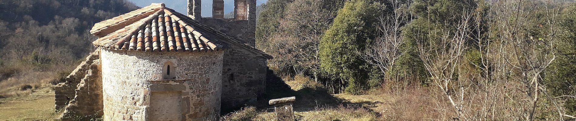
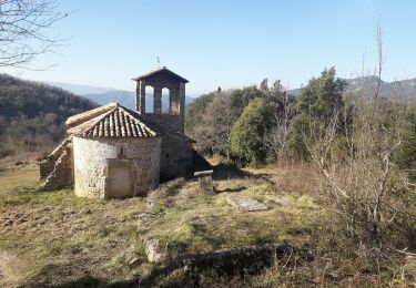
La ruta és un passeig molt agradable per les obagues de Clot Mal, el torrent que drena els caients de l’ermita del Freixe. Es camina pel mig de dues boixedes, es creua dues vegades Clot Mal i es pot beure aigua de l’arranjada font de Ca l’Espardenya
Website: https://www.itinerannia.net/ca/itineraris/ruta-dels-carboners-i-el-bac-ruta-3-mieres/
Positioning
Comments
Trails nearby
![Trail On foot Sant Ferriol - El Santuari del Collell: Presó de Guerra - Photo](https://media.geolcdn.com/t/375/260/d99155fb-0b90-41f2-88f0-967efb98deaf.jpeg&format=jpg&maxdim=2)
![On foot On foot](https://static1.geolcdn.com/sitytour/trail-icons/100.png)
On foot
![](/images/other/stat-length.png)
![](https://static1.geolcdn.com/siteimages/upload/files/16400158638029165_repeat_loop_refresh_sync_direction_icon.png)
![Trail On foot Mieres - Ruta dels carboners. Mieres - Photo](https://media.geolcdn.com/t/375/260/290ea93a-3def-4142-b339-4b864a71c8d5.jpeg&format=jpg&maxdim=2)
![On foot On foot](https://static1.geolcdn.com/sitytour/trail-icons/100.png)
On foot
![](/images/other/stat-length.png)
![](https://static1.geolcdn.com/siteimages/upload/files/16400158638029165_repeat_loop_refresh_sync_direction_icon.png)
![Trail On foot Mieres - El Balcó de Mieres - Photo](https://media.geolcdn.com/t/375/260/290ea93a-3def-4142-b339-4b864a71c8d5.jpeg&format=jpg&maxdim=2)
![On foot On foot](https://static1.geolcdn.com/sitytour/trail-icons/100.png)
On foot
![](/images/other/stat-length.png)
![](https://static1.geolcdn.com/siteimages/upload/files/16400158638029165_repeat_loop_refresh_sync_direction_icon.png)
![Trail On foot Sant Miquel de Campmajor - Ruta del veïnat de Roca i Briolf - Photo](https://media.geolcdn.com/t/375/260/ed1b8fda-1021-494f-a063-91a6cfa060a2.jpeg&format=jpg&maxdim=2)
![On foot On foot](https://static1.geolcdn.com/sitytour/trail-icons/100.png)
On foot
![](/images/other/stat-length.png)
![](https://static1.geolcdn.com/siteimages/upload/files/16400158638029165_repeat_loop_refresh_sync_direction_icon.png)
![Trail On foot Sant Aniol de Finestres - Finestres-Sant Aniol pel coll de Palomera - Photo](https://media.geolcdn.com/t/375/260/22fe7fa2-68fb-4d87-b3c5-e05cc3b80534.jpeg&format=jpg&maxdim=2)
![On foot On foot](https://static1.geolcdn.com/sitytour/trail-icons/100.png)
On foot
![](/images/other/stat-length.png)
![](https://static1.geolcdn.com/siteimages/upload/files/16400158638029165_repeat_loop_refresh_sync_direction_icon.png)
![Trail On foot Sant Miquel de Campmajor - El Refugi dels emboscats - Photo](https://media.geolcdn.com/t/375/260/ext.jpg?maxdim=2&url=https%3A%2F%2Fstatic1.geolcdn.com%2Fsiteimages%2Fupload%2Ffiles%2F1545311037marcheuse_200dpi.jpg)
![On foot On foot](https://static1.geolcdn.com/sitytour/trail-icons/100.png)
On foot
![](/images/other/stat-length.png)
![](https://static1.geolcdn.com/siteimages/upload/files/16400158638029165_repeat_loop_refresh_sync_direction_icon.png)