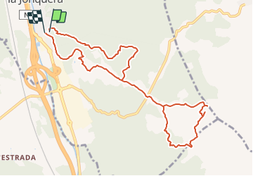
![](/images/other/stat-length.png)
![Trail On foot la Jonquera - Marxa dels dòlmens i ruta dels estanys - Photo](https://media.geolcdn.com/t/1900/400/fedcbff4-20db-4413-b792-cfa0f34dafa2.jpeg&format=pjpeg&maxdim=2)
Marxa dels dòlmens i ruta dels estanys
SityTrail - itinéraires balisés pédestres
Tous les sentiers balisés d’Europe GUIDE+
![Length](/images/other/stat-length.png)
![Max alt](https://static1.geolcdn.com/siteimages/upload/files/1508320355ic_sort_altitude_max_24dp.png)
![Uphill gradient](https://static1.geolcdn.com/siteimages/upload/files/1508320355ic_sort_den_pos_24dp.png)
![Km-Effort](/images/other/stat-length.png)
![Min alt](https://static1.geolcdn.com/siteimages/upload/files/1508320355ic_sort_altitude_min_24dp.png)
![Downhill gradient](https://static1.geolcdn.com/siteimages/upload/files/1508320355ic_sort_den_neg_24dp.png)
![Boucle](https://static1.geolcdn.com/siteimages/upload/files/16400158638029165_repeat_loop_refresh_sync_direction_icon.png)
![On foot](https://static1.geolcdn.com/sitytour/trail-icons/100.png)
3h17
Difficulty : Easy
![Scan this QR Code to open this trail in the SityTrail application](https://capi.geolives.com/qq0zvz2zws4bq2lad0pu/sitytour/trails/3110493/qr.png?size=200)
FREE GPS app for hiking
About
Trail On foot of 11.5 km to be discovered at Catalonia, Girona, la Jonquera. This trail is proposed by SityTrail - itinéraires balisés pédestres.
Description
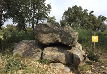
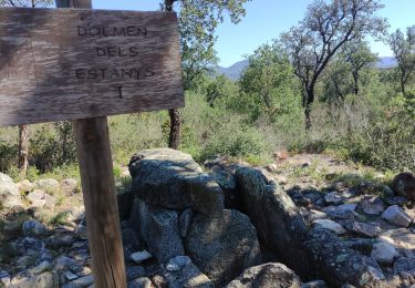
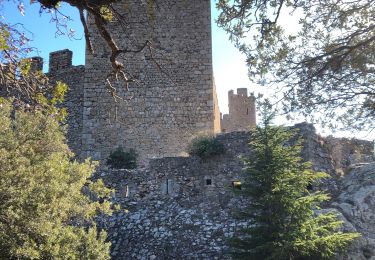
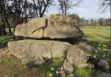
El Centre Excursionista Jonquerenc, organitza des de l’any 1983 la popular Marxa dels Dòlmens, senyalitzada en aquesta ruta. La zona humida dels estanys està inclosa dins el PEIN “Estanys de la Jonquera” i englobat dins els espais de la Xarxa Natura 2000
Website: https://www.itinerannia.net/ca/itineraris/marxa-dels-dolmens-i-ruta-dels-estanys-ruta-15-alt-emporda/
Positioning
Comments
Trails nearby
![Trail On foot Capmany - Itinerari megalític de Campmany - Photo](https://media.geolcdn.com/t/375/260/869eddc9-99f0-4850-9d15-c9f49ca84b69.jpeg&format=jpg&maxdim=2)
![On foot On foot](https://static1.geolcdn.com/sitytour/trail-icons/100.png)
On foot
![](/images/other/stat-length.png)
![](https://static1.geolcdn.com/siteimages/upload/files/16400158638029165_repeat_loop_refresh_sync_direction_icon.png)
![Trail On foot la Jonquera - PR-C 71 La Jonquera-Portbou - Photo](https://media.geolcdn.com/t/375/260/5e6d3380-2250-4b33-97db-8f0c01794288.jpeg&format=jpg&maxdim=2)
![On foot On foot](https://static1.geolcdn.com/sitytour/trail-icons/100.png)
On foot
![](/images/other/stat-length.png)
![](https://static1.geolcdn.com/siteimages/upload/files/16400158638029165_repeat_loop_refresh_sync_direction_icon.png)
![Trail Walking Le Perthus - penissar - Photo](https://media.geolcdn.com/t/375/260/db553a64-848c-49b3-ac51-caf4a414d04b.jpg&format=jpg&maxdim=2)
![Walking Walking](https://static1.geolcdn.com/sitytour/trail-icons/101.png)
Walking
![](/images/other/stat-length.png)
![](https://static1.geolcdn.com/siteimages/upload/files/16400158638029165_repeat_loop_refresh_sync_direction_icon.png)
![Trail Walking la Jonquera - CIRCUIT DES MÉGALITHES depuis EL FOGON - Photo](https://media.geolcdn.com/t/375/260/7a6e5bb6-23f5-4b50-857a-537a11402d8b.jpg&format=jpg&maxdim=2)
![Walking Walking](https://static1.geolcdn.com/sitytour/trail-icons/101.png)
Walking
![](/images/other/stat-length.png)
![](https://static1.geolcdn.com/siteimages/upload/files/16400158638029165_repeat_loop_refresh_sync_direction_icon.png)
![Trail Walking la Jonquera - 20230112 Site mégalithique- château Requesens - Photo](https://media.geolcdn.com/t/375/260/434ae223-eff4-4144-bd74-a07ff9e915d6.jpg&format=jpg&maxdim=2)
![Walking Walking](https://static1.geolcdn.com/sitytour/trail-icons/101.png)
Walking
![](/images/other/stat-length.png)
![](https://static1.geolcdn.com/siteimages/upload/files/16400158638029165_repeat_loop_refresh_sync_direction_icon.png)
![Trail Walking Le Perthus - palissades. la carboniere . fort de bellegrade . panissars - Photo](https://media.geolcdn.com/t/375/260/ed24b436-d9f9-4bce-9f3c-0eb2cbedcc4f.jpg&format=jpg&maxdim=2)
![Walking Walking](https://static1.geolcdn.com/sitytour/trail-icons/101.png)
Walking
![](/images/other/stat-length.png)
![](https://static1.geolcdn.com/siteimages/upload/files/16400158638029165_repeat_loop_refresh_sync_direction_icon.png)
![Trail Walking Le Perthus - Panissars_Fort-Belgarde - Photo](https://media.geolcdn.com/t/375/260/ext.jpg?maxdim=2&url=https%3A%2F%2Fservices.sitytrail.com%2FGeolivesWS%2FDownloadMedia.ashx%3FTrailID%3D572198%26Media%3Dfix__20160520173218.jpg)
![Walking Walking](https://static1.geolcdn.com/sitytour/trail-icons/101.png)
Walking
![](/images/other/stat-length.png)
![](https://static1.geolcdn.com/siteimages/upload/files/16400158638029165_repeat_loop_refresh_sync_direction_icon.png)
![Trail Walking Le Perthus - 66 LE PERTHUS - col de Panissars - GR10 - pistes - fort de Bellegarde - Photo](https://media.geolcdn.com/t/375/260/ext.jpg?maxdim=2&url=https%3A%2F%2Fservices.sitytrail.com%2FGeolivesWS%2FDownloadMedia.ashx%3FTrailID%3D473083%26Media%3D20150918174636.jpg)
![Walking Walking](https://static1.geolcdn.com/sitytour/trail-icons/101.png)
Walking
![](/images/other/stat-length.png)
![](https://static1.geolcdn.com/siteimages/upload/files/16400158638029165_repeat_loop_refresh_sync_direction_icon.png)
![Trail Walking Capmany - Capmany Mégalithique_2 - Photo](https://media.geolcdn.com/t/375/260/ext.jpg?maxdim=2&url=https%3A%2F%2Fservices.sitytrail.com%2FGeolivesWS%2FDownloadMedia.ashx%3FTrailID%3D304677%26Media%3D70129613-bd6d-4e80-a4c3-608884f2ea29.jpeg)
![Walking Walking](https://static1.geolcdn.com/sitytour/trail-icons/101.png)
Walking
![](/images/other/stat-length.png)
![](https://static1.geolcdn.com/siteimages/upload/files/16400158638029165_repeat_loop_refresh_sync_direction_icon.png)