![](/images/other/stat-length.png)
![Trail On foot Montagut i Oix - Montagut-Ermita de la Devesa-Baumes de la Caxurma - Photo](https://media.geolcdn.com/t/1900/400/1fea31c6-a1f7-4cd5-9fb2-91cc07d26e9e.jpeg&format=pjpeg&maxdim=2)
Montagut-Ermita de la Devesa-Baumes de la Caxurma
SityTrail - itinéraires balisés pédestres
Tous les sentiers balisés d’Europe GUIDE+
![Length](/images/other/stat-length.png)
![Max alt](https://static1.geolcdn.com/siteimages/upload/files/1508320355ic_sort_altitude_max_24dp.png)
![Uphill gradient](https://static1.geolcdn.com/siteimages/upload/files/1508320355ic_sort_den_pos_24dp.png)
![Km-Effort](/images/other/stat-length.png)
![Min alt](https://static1.geolcdn.com/siteimages/upload/files/1508320355ic_sort_altitude_min_24dp.png)
![Downhill gradient](https://static1.geolcdn.com/siteimages/upload/files/1508320355ic_sort_den_neg_24dp.png)
![Boucle](https://static1.geolcdn.com/siteimages/upload/files/16400158638029165_repeat_loop_refresh_sync_direction_icon.png)
![On foot](https://static1.geolcdn.com/sitytour/trail-icons/100.png)
4h22
Difficulty : Easy
![Scan this QR Code to open this trail in the SityTrail application](https://capi.geolives.com/qq0zvz2zws4bq2lad0pu/sitytour/trails/3110434/qr.png?size=200)
FREE GPS app for hiking
About
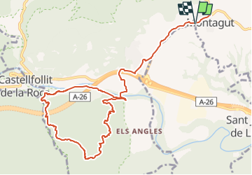
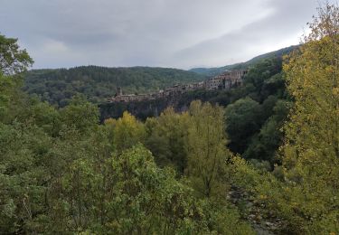
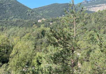
Trail On foot of 13.1 km to be discovered at Catalonia, Girona, Montagut i Oix. This trail is proposed by SityTrail - itinéraires balisés pédestres.
Description
Les Baumes de Caxurma són un conjunt de cavitats ubicades en els materials sedimentaris del sud de la cinglera basàltica de Castellfollit de la Roca, la cavitat més important té uns 400 metres de recorregut
Website: https://www.itinerannia.net/ca/itineraris/ruta-la-devesa-i-les-baumes-de-caxurma-ruta-1-montagut-i-oix/
Positioning
Comments
Trails nearby
![Trail On foot Tortellà - Els Comuns. Tortellà - Photo](https://media.geolcdn.com/t/375/260/77e3f571-f015-4fa3-9216-7388ce4a3e2a.jpeg&format=jpg&maxdim=2)
![On foot On foot](https://static1.geolcdn.com/sitytour/trail-icons/100.png)
On foot
![](/images/other/stat-length.png)
![](https://static1.geolcdn.com/siteimages/upload/files/16400158638029165_repeat_loop_refresh_sync_direction_icon.png)
![Trail On foot Sales de Llierca - L'Alta Garrotxa de Vayreda - Photo](https://media.geolcdn.com/t/375/260/f52cff0d-f5c0-40bd-a266-b7fc01d75938.jpeg&format=jpg&maxdim=2)
![On foot On foot](https://static1.geolcdn.com/sitytour/trail-icons/100.png)
On foot
![](/images/other/stat-length.png)
![](https://static1.geolcdn.com/siteimages/upload/files/16400158638029165_repeat_loop_refresh_sync_direction_icon.png)
![Trail Walking Montagut i Oix - CASTELLFOLLIT DE LA ROCA - Photo](https://media.geolcdn.com/t/375/260/ea60c58d-17d7-42f2-85ca-a29d0fa72faa.jpg&format=jpg&maxdim=2)
![Walking Walking](https://static1.geolcdn.com/sitytour/trail-icons/101.png)
Walking
![](/images/other/stat-length.png)
![](https://static1.geolcdn.com/siteimages/upload/files/16400158638029165_repeat_loop_refresh_sync_direction_icon.png)
![Trail Walking Sales de Llierca - Sadernes Sant Aniol - Photo](https://media.geolcdn.com/t/375/260/db335b61-6ee0-4b21-a956-4377b2f8d2ee.jpg&format=jpg&maxdim=2)
![Walking Walking](https://static1.geolcdn.com/sitytour/trail-icons/101.png)
Walking
![](/images/other/stat-length.png)
![](https://static1.geolcdn.com/siteimages/upload/files/16400158638029165_repeat_loop_refresh_sync_direction_icon.png)
![Trail Walking Tortellà - Llercat Saderne - Photo](https://media.geolcdn.com/t/375/260/6cdc333b-3a4b-4d4a-a55a-45043c793942.jpg&format=jpg&maxdim=2)
![Walking Walking](https://static1.geolcdn.com/sitytour/trail-icons/101.png)
Walking
![](/images/other/stat-length.png)
![](https://static1.geolcdn.com/siteimages/upload/files/16400158638029165_repeat_loop_refresh_sync_direction_icon.png)
![Trail Walking Sales de Llierca - Gorges de St Aniol Sadernes - Photo](https://media.geolcdn.com/t/375/260/ext.jpg?maxdim=2&url=https%3A%2F%2Fservices.sitytrail.com%2FGeolivesWS%2FDownloadMedia.ashx%3FTrailID%3D419570%26Media%3Dfix__20150510175851.jpg)
![Walking Walking](https://static1.geolcdn.com/sitytour/trail-icons/101.png)
Walking
![](/images/other/stat-length.png)
![](https://static1.geolcdn.com/siteimages/upload/files/16400158638029165_repeat_loop_refresh_sync_direction_icon.png)
![Trail Walking Castellfollit de la Roca - j3 - Photo](https://media.geolcdn.com/t/375/260/ext.jpg?maxdim=2&url=https%3A%2F%2Fstatic1.geolcdn.com%2Fsiteimages%2Fupload%2Ffiles%2F1553511878bg_sport_marche.png)
![Walking Walking](https://static1.geolcdn.com/sitytour/trail-icons/101.png)
Walking
![](/images/other/stat-length.png)
![](https://static1.geolcdn.com/siteimages/upload/files/16400158638029165_repeat_loop_refresh_sync_direction_icon.png)
![Trail Walking Sales de Llierca - Pont de Llerca Saderne variante à compléter - Photo](https://media.geolcdn.com/t/375/260/fb165c9a-bd67-49ad-93ac-789b57a6b3b3.jpg&format=jpg&maxdim=2)
![Walking Walking](https://static1.geolcdn.com/sitytour/trail-icons/101.png)
Walking
![](/images/other/stat-length.png)
![](https://static1.geolcdn.com/siteimages/upload/files/16400158638029165_repeat_loop_refresh_sync_direction_icon.png)
![Trail Walking Castellfollit de la Roca - Castellfolit de la Roca vers San Juan de Fonts - Photo](https://media.geolcdn.com/t/375/260/ext.jpg?maxdim=2&url=https%3A%2F%2Fstatic1.geolcdn.com%2Fsiteimages%2Fupload%2Ffiles%2F1553511878bg_sport_marche.png)
![Walking Walking](https://static1.geolcdn.com/sitytour/trail-icons/101.png)
Walking
![](/images/other/stat-length.png)
![](https://static1.geolcdn.com/siteimages/upload/files/16400158638029165_repeat_loop_refresh_sync_direction_icon.png)