![](/images/other/stat-length.png)
![Trail On foot San Andrés y Sauces - Sendero Autoguiado - Un balcón atravesado entre las brumas - Photo](https://media.geolcdn.com/t/1900/400/1118cbb1-886d-4dc6-a0ac-82615554addb.jpeg&format=pjpeg&maxdim=2)
Sendero Autoguiado - Un balcón atravesado entre las brumas
SityTrail - itinéraires balisés pédestres
Tous les sentiers balisés d’Europe GUIDE+
![Length](/images/other/stat-length.png)
Length
5.2 km
![Max alt](https://static1.geolcdn.com/siteimages/upload/files/1508320355ic_sort_altitude_max_24dp.png)
Max alt
752 m
![Uphill gradient](https://static1.geolcdn.com/siteimages/upload/files/1508320355ic_sort_den_pos_24dp.png)
Uphill gradient
386 m
![Km-Effort](/images/other/stat-length.png)
Km-Effort
10.4 km
![Min alt](https://static1.geolcdn.com/siteimages/upload/files/1508320355ic_sort_altitude_min_24dp.png)
Min alt
464 m
![Downhill gradient](https://static1.geolcdn.com/siteimages/upload/files/1508320355ic_sort_den_neg_24dp.png)
Downhill gradient
408 m
![Boucle](https://static1.geolcdn.com/siteimages/upload/files/16400158638029165_repeat_loop_refresh_sync_direction_icon.png)
Boucle
Yes
Signpost
Creation date :
2022-02-14 15:28:32.071
Updated on :
2022-02-14 15:28:32.071
![On foot](https://static1.geolcdn.com/sitytour/trail-icons/100.png)
2h21
Difficulty : Easy
![Scan this QR Code to open this trail in the SityTrail application](https://capi.geolives.com/qq0zvz2zws4bq2lad0pu/sitytour/trails/3110202/qr.png?size=200)
FREE GPS app for hiking
About
Trail On foot of 5.2 km to be discovered at Canary Islands, Santa Cruz de Tenerife, San Andrés y Sauces. This trail is proposed by SityTrail - itinéraires balisés pédestres.
Description
Website: http://www.senderosdelapalma.es/senderos/lista-de-senderos/senderos-autoguiados/
Positioning
Country:
Spain
Region :
Canary Islands
Department/Province :
Santa Cruz de Tenerife
Municipality :
San Andrés y Sauces
Location:
Unknown
Start:(Dec)
Start:(UTM)
226609 ; 3187917 (28R) N.
Comments
Trails nearby
![Trail On foot Barlovento - SL LP 40 Barlovento-La Palmita - Photo](https://media.geolcdn.com/t/375/260/82ebbd9a-b84a-4fc5-830c-865d1d44e856.jpeg&format=jpg&maxdim=2)
![On foot On foot](https://static1.geolcdn.com/sitytour/trail-icons/100.png)
SL LP 40 Barlovento-La Palmita
On foot
Easy
Barlovento,
Canary Islands,
Santa Cruz de Tenerife,
Spain
![](/images/other/stat-length.png)
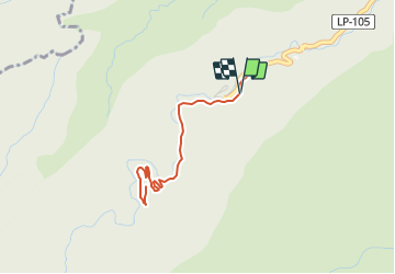
4.3 km | 5.9 km-effort
1h 20min
![](https://static1.geolcdn.com/siteimages/upload/files/16400158638029165_repeat_loop_refresh_sync_direction_icon.png)
No
![Walking Walking](https://static1.geolcdn.com/sitytour/trail-icons/101.png)
Wikiloc - La Palma Los Tillos 50%
Walking
Difficult
San Andrés y Sauces,
Canary Islands,
Santa Cruz de Tenerife,
Spain
![](/images/other/stat-length.png)
6.3 km | 12.9 km-effort
3h 57min
![](https://static1.geolcdn.com/siteimages/upload/files/16400158638029165_repeat_loop_refresh_sync_direction_icon.png)
Yes
![Trail Walking Puntallana - La Palma-La Galga-PR2 - Photo](https://media.geolcdn.com/t/375/260/ext.jpg?maxdim=2&url=https%3A%2F%2Fstatic1.geolcdn.com%2Fsiteimages%2Fupload%2Ffiles%2F1553511878bg_sport_marche.png)
![Walking Walking](https://static1.geolcdn.com/sitytour/trail-icons/101.png)
La Palma-La Galga-PR2
Walking
Easy
Puntallana,
Canary Islands,
Santa Cruz de Tenerife,
Spain
![](/images/other/stat-length.png)
4.4 km | 7.6 km-effort
1h 20min
![](https://static1.geolcdn.com/siteimages/upload/files/16400158638029165_repeat_loop_refresh_sync_direction_icon.png)
Yes
![Trail Walking San Andrés y Sauces - La Palma - San Andres - Photo](https://media.geolcdn.com/t/375/260/ext.jpg?maxdim=2&url=https%3A%2F%2Fstatic1.geolcdn.com%2Fsiteimages%2Fupload%2Ffiles%2F1553511878bg_sport_marche.png)
![Walking Walking](https://static1.geolcdn.com/sitytour/trail-icons/101.png)
La Palma - San Andres
Walking
Easy
San Andrés y Sauces,
Canary Islands,
Santa Cruz de Tenerife,
Spain
![](/images/other/stat-length.png)
7.7 km | 13.9 km-effort
2h 41min
![](https://static1.geolcdn.com/siteimages/upload/files/16400158638029165_repeat_loop_refresh_sync_direction_icon.png)
No
![Trail Walking San Andrés y Sauces - La Palma - Los Tilos - Photo](https://media.geolcdn.com/t/375/260/ext.jpg?maxdim=2&url=https%3A%2F%2Fstatic1.geolcdn.com%2Fsiteimages%2Fupload%2Ffiles%2F1553511878bg_sport_marche.png)
![Walking Walking](https://static1.geolcdn.com/sitytour/trail-icons/101.png)
La Palma - Los Tilos
Walking
Difficult
San Andrés y Sauces,
Canary Islands,
Santa Cruz de Tenerife,
Spain
![](/images/other/stat-length.png)
21 km | 45 km-effort
6h 37min
![](https://static1.geolcdn.com/siteimages/upload/files/16400158638029165_repeat_loop_refresh_sync_direction_icon.png)
No