![](/images/other/stat-length.png)
![Trail On foot Brummen - NL-Extension of NS-Wandeltocht Uiterwaarden van Cortenoever - Photo](https://media.geolcdn.com/t/1900/400/93a9c4c6-7c78-4551-a6c2-3d1579e46df8.jpeg&format=pjpeg&maxdim=2)
NL-Extension of NS-Wandeltocht Uiterwaarden van Cortenoever
SityTrail - itinéraires balisés pédestres
Tous les sentiers balisés d’Europe GUIDE+
![Length](/images/other/stat-length.png)
Length
3.1 km
![Max alt](https://static1.geolcdn.com/siteimages/upload/files/1508320355ic_sort_altitude_max_24dp.png)
Max alt
11 m
![Uphill gradient](https://static1.geolcdn.com/siteimages/upload/files/1508320355ic_sort_den_pos_24dp.png)
Uphill gradient
11 m
![Km-Effort](/images/other/stat-length.png)
Km-Effort
3.2 km
![Min alt](https://static1.geolcdn.com/siteimages/upload/files/1508320355ic_sort_altitude_min_24dp.png)
Min alt
5 m
![Downhill gradient](https://static1.geolcdn.com/siteimages/upload/files/1508320355ic_sort_den_neg_24dp.png)
Downhill gradient
11 m
![Boucle](https://static1.geolcdn.com/siteimages/upload/files/16400158638029165_repeat_loop_refresh_sync_direction_icon.png)
Boucle
No
Signpost
Creation date :
2022-02-14 15:23:20.886
Updated on :
2022-02-14 15:23:20.886
![On foot](https://static1.geolcdn.com/sitytour/trail-icons/100.png)
44m
Difficulty : Easy
![Scan this QR Code to open this trail in the SityTrail application](https://capi.geolives.com/qq0zvz2zws4bq2lad0pu/sitytour/trails/3110110/qr.png?size=200)
FREE GPS app for hiking
About
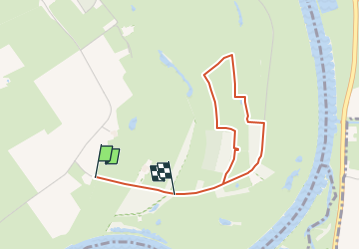
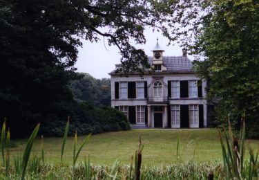
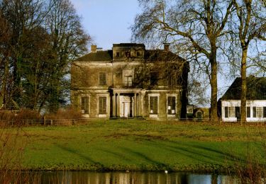
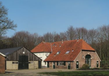
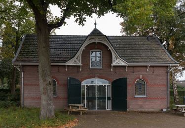
Trail On foot of 3.1 km to be discovered at Gelderland, Unknown, Brummen. This trail is proposed by SityTrail - itinéraires balisés pédestres.
Description
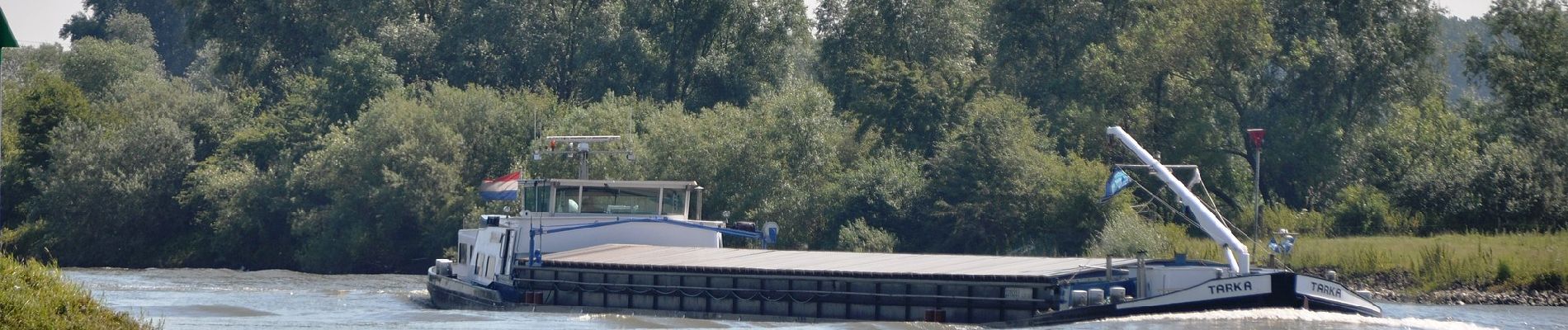
Wandel vanaf de oude dijk naar het Laarzenpad, dwars door een natuurreservaat.
Website: https://www.ns.nl/dagje-uit/wandelen/uiterwaarden-van-cortenoever.html
Positioning
Country:
Netherlands
Region :
Gelderland
Department/Province :
Unknown
Municipality :
Brummen
Location:
Unknown
Start:(Dec)
Start:(UTM)
308111 ; 5775553 (32U) N.
Comments
Trails nearby
![Trail On foot Brummen - Leuvenschepad (Klompenpad) - Photo](https://media.geolcdn.com/t/375/260/561621ce-c6fc-40bc-90d0-4401b38aeb2f.jpeg&format=jpg&maxdim=2)
![On foot On foot](https://static1.geolcdn.com/sitytour/trail-icons/100.png)
Leuvenschepad (Klompenpad)
On foot
Easy
Brummen,
Gelderland,
Unknown,
Netherlands
![](/images/other/stat-length.png)
9.3 km | 10 km-effort
2h 16min
![](https://static1.geolcdn.com/siteimages/upload/files/16400158638029165_repeat_loop_refresh_sync_direction_icon.png)
No
![Trail On foot Brummen - NS-Wandeltocht Uiterwaarden van Cortenoever - Photo](https://media.geolcdn.com/t/375/260/a4ca8298-8925-41e7-a093-709cdef1b170.jpeg&format=jpg&maxdim=2)
![On foot On foot](https://static1.geolcdn.com/sitytour/trail-icons/100.png)
NS-Wandeltocht Uiterwaarden van Cortenoever
On foot
Easy
Brummen,
Gelderland,
Unknown,
Netherlands
![](/images/other/stat-length.png)
12 km | 12.8 km-effort
2h 54min
![](https://static1.geolcdn.com/siteimages/upload/files/16400158638029165_repeat_loop_refresh_sync_direction_icon.png)
No
![Trail On foot Zutphen - Leestensche Broekpad (Klompenpad) - Photo](https://media.geolcdn.com/t/375/260/44e3f8db-a211-4e70-b435-60081fcd3243.jpeg&format=jpg&maxdim=2)
![On foot On foot](https://static1.geolcdn.com/sitytour/trail-icons/100.png)
Leestensche Broekpad (Klompenpad)
On foot
Easy
Zutphen,
Gelderland,
Unknown,
Netherlands
![](/images/other/stat-length.png)
11.7 km | 12.6 km-effort
2h 51min
![](https://static1.geolcdn.com/siteimages/upload/files/16400158638029165_repeat_loop_refresh_sync_direction_icon.png)
Yes
![Trail On foot Brummen - rode wandelroute Voorstonden 7 km - Photo](https://media.geolcdn.com/t/375/260/428d914c-4f41-4732-9114-8e7261a736a9.jpeg&format=jpg&maxdim=2)
![On foot On foot](https://static1.geolcdn.com/sitytour/trail-icons/100.png)
rode wandelroute Voorstonden 7 km
On foot
Easy
Brummen,
Gelderland,
Unknown,
Netherlands
![](/images/other/stat-length.png)
6.3 km | 7.3 km-effort
1h 39min
![](https://static1.geolcdn.com/siteimages/upload/files/16400158638029165_repeat_loop_refresh_sync_direction_icon.png)
Yes
![Trail On foot Brummen - Dwars door Gelderland (18) - Photo](https://media.geolcdn.com/t/375/260/10c78f16-8829-4f8a-8baa-3d107f22012b.jpeg&format=jpg&maxdim=2)
![On foot On foot](https://static1.geolcdn.com/sitytour/trail-icons/100.png)
Dwars door Gelderland (18)
On foot
Easy
Brummen,
Gelderland,
Unknown,
Netherlands
![](/images/other/stat-length.png)
7.6 km | 8.3 km-effort
1h 52min
![](https://static1.geolcdn.com/siteimages/upload/files/16400158638029165_repeat_loop_refresh_sync_direction_icon.png)
No
![Trail Cycle Bronckhorst - f-gelderland-landgoedroute - Photo](https://media.geolcdn.com/t/375/260/ext.jpg?maxdim=2&url=https%3A%2F%2Fstatic1.geolcdn.com%2Fsiteimages%2Fupload%2Ffiles%2F1524743154velo.jpg)
![Cycle Cycle](https://static1.geolcdn.com/sitytour/trail-icons/200.png)
f-gelderland-landgoedroute
Cycle
Very easy
Bronckhorst,
Gelderland,
Unknown,
Netherlands
![](/images/other/stat-length.png)
42 km | 46 km-effort
Unknown
![](https://static1.geolcdn.com/siteimages/upload/files/16400158638029165_repeat_loop_refresh_sync_direction_icon.png)
Yes
![Trail Cycle Bronckhorst - f-gelderland-bronckhorst-z-w - Photo](https://media.geolcdn.com/t/375/260/ext.jpg?maxdim=2&url=https%3A%2F%2Fstatic1.geolcdn.com%2Fsiteimages%2Fupload%2Ffiles%2F1524743154velo.jpg)
![Cycle Cycle](https://static1.geolcdn.com/sitytour/trail-icons/200.png)
f-gelderland-bronckhorst-z-w
Cycle
Very easy
Bronckhorst,
Gelderland,
Unknown,
Netherlands
![](/images/other/stat-length.png)
46 km | 49 km-effort
Unknown
![](https://static1.geolcdn.com/siteimages/upload/files/16400158638029165_repeat_loop_refresh_sync_direction_icon.png)
Yes
![Trail Walking Bronckhorst - w-gelderland-ockhorstroute - Photo](https://media.geolcdn.com/t/375/260/ext.jpg?maxdim=2&url=https%3A%2F%2Fstatic1.geolcdn.com%2Fsiteimages%2Fupload%2Ffiles%2F1553511878bg_sport_marche.png)
![Walking Walking](https://static1.geolcdn.com/sitytour/trail-icons/101.png)
w-gelderland-ockhorstroute
Walking
Very easy
Bronckhorst,
Gelderland,
Unknown,
Netherlands
![](/images/other/stat-length.png)
7.6 km | 8.3 km-effort
Unknown
![](https://static1.geolcdn.com/siteimages/upload/files/16400158638029165_repeat_loop_refresh_sync_direction_icon.png)
Yes
![Trail Walking Bronckhorst - w-gelderland-hsl-struinroute - Photo](https://media.geolcdn.com/t/375/260/ext.jpg?maxdim=2&url=https%3A%2F%2Fstatic1.geolcdn.com%2Fsiteimages%2Fupload%2Ffiles%2F1553511878bg_sport_marche.png)
![Walking Walking](https://static1.geolcdn.com/sitytour/trail-icons/101.png)
w-gelderland-hsl-struinroute
Walking
Very easy
Bronckhorst,
Gelderland,
Unknown,
Netherlands
![](/images/other/stat-length.png)
8.8 km | 9.3 km-effort
Unknown
![](https://static1.geolcdn.com/siteimages/upload/files/16400158638029165_repeat_loop_refresh_sync_direction_icon.png)
Yes