![](/images/other/stat-length.png)
![Trail On foot Lochem - De Boschheurne Route - Photo](https://media.geolcdn.com/t/1900/400/7fc336cf-e104-491e-940c-7899e0be83de.jpeg&format=pjpeg&maxdim=2)
De Boschheurne Route
SityTrail - itinéraires balisés pédestres
Tous les sentiers balisés d’Europe GUIDE+
![Length](/images/other/stat-length.png)
Length
11.4 km
![Max alt](https://static1.geolcdn.com/siteimages/upload/files/1508320355ic_sort_altitude_max_24dp.png)
Max alt
26 m
![Uphill gradient](https://static1.geolcdn.com/siteimages/upload/files/1508320355ic_sort_den_pos_24dp.png)
Uphill gradient
60 m
![Km-Effort](/images/other/stat-length.png)
Km-Effort
12.2 km
![Min alt](https://static1.geolcdn.com/siteimages/upload/files/1508320355ic_sort_altitude_min_24dp.png)
Min alt
11 m
![Downhill gradient](https://static1.geolcdn.com/siteimages/upload/files/1508320355ic_sort_den_neg_24dp.png)
Downhill gradient
60 m
![Boucle](https://static1.geolcdn.com/siteimages/upload/files/16400158638029165_repeat_loop_refresh_sync_direction_icon.png)
Boucle
Yes
Signpost
Creation date :
2022-02-14 15:16:22.108
Updated on :
2022-02-14 15:16:22.108
![On foot](https://static1.geolcdn.com/sitytour/trail-icons/100.png)
2h45
Difficulty : Easy
![Scan this QR Code to open this trail in the SityTrail application](https://capi.geolives.com/qq0zvz2zws4bq2lad0pu/sitytour/trails/3109922/qr.png?size=200)
FREE GPS app for hiking
About
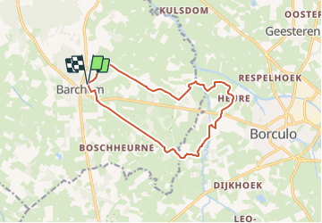
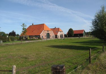
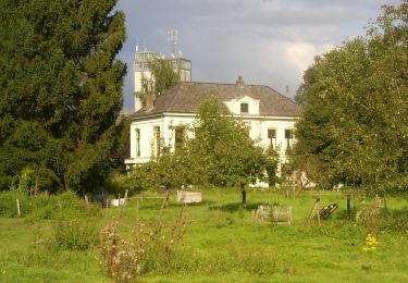
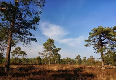
Trail On foot of 11.4 km to be discovered at Gelderland, Unknown, Lochem. This trail is proposed by SityTrail - itinéraires balisés pédestres.
Description
Trail created by Stichting Achterhoek Toerisme.
Website: https://achterhoek.nl/Boscheurne-Galgenkamproute
Positioning
Country:
Netherlands
Region :
Gelderland
Department/Province :
Unknown
Municipality :
Lochem
Location:
Unknown
Start:(Dec)
Start:(UTM)
325236 ; 5778194 (32U) N.
Comments
Trails nearby
![Trail On foot Lochem - Lochemse Berg Route - Photo](https://media.geolcdn.com/t/375/260/0b3bf5ef-5885-40ac-820f-254b98fec905.jpeg&format=jpg&maxdim=2)
![On foot On foot](https://static1.geolcdn.com/sitytour/trail-icons/100.png)
Lochemse Berg Route
On foot
Easy
Lochem,
Gelderland,
Unknown,
Netherlands
![](/images/other/stat-length.png)
8.5 km | 10.1 km-effort
2h 18min
![](https://static1.geolcdn.com/siteimages/upload/files/16400158638029165_repeat_loop_refresh_sync_direction_icon.png)
Yes
![Trail On foot Berkelland - Heureroute - Photo](https://media.geolcdn.com/t/375/260/ec6c9ad2-fc8c-4dc6-9885-45083a89b555.jpeg&format=jpg&maxdim=2)
![On foot On foot](https://static1.geolcdn.com/sitytour/trail-icons/100.png)
Heureroute
On foot
Easy
Berkelland,
Gelderland,
Unknown,
Netherlands
![](/images/other/stat-length.png)
6 km | 6.4 km-effort
1h 27min
![](https://static1.geolcdn.com/siteimages/upload/files/16400158638029165_repeat_loop_refresh_sync_direction_icon.png)
Yes
![Trail On foot Lochem - Rondje Barchem - Photo](https://media.geolcdn.com/t/375/260/7fc336cf-e104-491e-940c-7899e0be83de.jpeg&format=jpg&maxdim=2)
![On foot On foot](https://static1.geolcdn.com/sitytour/trail-icons/100.png)
Rondje Barchem
On foot
Easy
Lochem,
Gelderland,
Unknown,
Netherlands
![](/images/other/stat-length.png)
12.6 km | 13.6 km-effort
3h 6min
![](https://static1.geolcdn.com/siteimages/upload/files/16400158638029165_repeat_loop_refresh_sync_direction_icon.png)
Yes
![Trail On foot Lochem - Barchems Wandel Ommetje - Photo](https://media.geolcdn.com/t/375/260/7fc336cf-e104-491e-940c-7899e0be83de.jpeg&format=jpg&maxdim=2)
![On foot On foot](https://static1.geolcdn.com/sitytour/trail-icons/100.png)
Barchems Wandel Ommetje
On foot
Easy
Lochem,
Gelderland,
Unknown,
Netherlands
![](/images/other/stat-length.png)
5.9 km | 6.3 km-effort
1h 26min
![](https://static1.geolcdn.com/siteimages/upload/files/16400158638029165_repeat_loop_refresh_sync_direction_icon.png)
Yes
![Trail On foot Bronckhorst - De Wildenborch Route - Photo](https://media.geolcdn.com/t/375/260/03237455-549e-486d-9ec0-9a1319ae6ede.jpeg&format=jpg&maxdim=2)
![On foot On foot](https://static1.geolcdn.com/sitytour/trail-icons/100.png)
De Wildenborch Route
On foot
Easy
Bronckhorst,
Gelderland,
Unknown,
Netherlands
![](/images/other/stat-length.png)
6.5 km | 7 km-effort
1h 35min
![](https://static1.geolcdn.com/siteimages/upload/files/16400158638029165_repeat_loop_refresh_sync_direction_icon.png)
Yes
![Trail On foot Lochem - Poort van Lochem - Photo](https://media.geolcdn.com/t/375/260/845ff6b2-8648-434a-929d-70c911bb0eaf.jpeg&format=jpg&maxdim=2)
![On foot On foot](https://static1.geolcdn.com/sitytour/trail-icons/100.png)
Poort van Lochem
On foot
Easy
Lochem,
Gelderland,
Unknown,
Netherlands
![](/images/other/stat-length.png)
11.8 km | 12.7 km-effort
2h 53min
![](https://static1.geolcdn.com/siteimages/upload/files/16400158638029165_repeat_loop_refresh_sync_direction_icon.png)
Yes
![Trail On foot Lochem - Hof van Gelre route - Photo](https://media.geolcdn.com/t/375/260/76046cee-7211-4169-ab7f-ed32bbd399f8.jpeg&format=jpg&maxdim=2)
![On foot On foot](https://static1.geolcdn.com/sitytour/trail-icons/100.png)
Hof van Gelre route
On foot
Easy
Lochem,
Gelderland,
Unknown,
Netherlands
![](/images/other/stat-length.png)
4.2 km | 4.4 km-effort
1h 0min
![](https://static1.geolcdn.com/siteimages/upload/files/16400158638029165_repeat_loop_refresh_sync_direction_icon.png)
Yes
![Trail On foot Lochem - Grote Veldroute - Photo](https://media.geolcdn.com/t/375/260/c3f659ef-52a0-470b-ae39-f1723f5a44e6.jpeg&format=jpg&maxdim=2)
![On foot On foot](https://static1.geolcdn.com/sitytour/trail-icons/100.png)
Grote Veldroute
On foot
Easy
Lochem,
Gelderland,
Unknown,
Netherlands
![](/images/other/stat-length.png)
15.6 km | 17.1 km-effort
3h 53min
![](https://static1.geolcdn.com/siteimages/upload/files/16400158638029165_repeat_loop_refresh_sync_direction_icon.png)
Yes
![Trail On foot Lochem - Kale Berg Route - Photo](https://media.geolcdn.com/t/375/260/7fc336cf-e104-491e-940c-7899e0be83de.jpeg&format=jpg&maxdim=2)
![On foot On foot](https://static1.geolcdn.com/sitytour/trail-icons/100.png)
Kale Berg Route
On foot
Easy
Lochem,
Gelderland,
Unknown,
Netherlands
![](/images/other/stat-length.png)
9.3 km | 10.6 km-effort
2h 24min
![](https://static1.geolcdn.com/siteimages/upload/files/16400158638029165_repeat_loop_refresh_sync_direction_icon.png)
Yes