![](/images/other/stat-length.png)
![Trail On foot A dos Cunhados e Maceira - Rota do Atlântico - Photo](https://media.geolcdn.com/t/1900/400/ext.pjpeg?maxdim=2&url=https%3A%2F%2Fmedia.geolcdn.com%2Ff%2F4c9a3719-f01b-44c7-9392-a1af5d775536.jpeg)
Rota do Atlântico
SityTrail - itinéraires balisés pédestres
Tous les sentiers balisés d’Europe PRO
![Length](/images/other/stat-length.png)
Length
3.4 km
![Max alt](https://static1.geolcdn.com/siteimages/upload/files/1508320355ic_sort_altitude_max_24dp.png)
Max alt
48 m
![Uphill gradient](https://static1.geolcdn.com/siteimages/upload/files/1508320355ic_sort_den_pos_24dp.png)
Uphill gradient
56 m
![Km-Effort](/images/other/stat-length.png)
Km-Effort
4.1 km
![Min alt](https://static1.geolcdn.com/siteimages/upload/files/1508320355ic_sort_altitude_min_24dp.png)
Min alt
4 m
![Downhill gradient](https://static1.geolcdn.com/siteimages/upload/files/1508320355ic_sort_den_neg_24dp.png)
Downhill gradient
42 m
![Boucle](https://static1.geolcdn.com/siteimages/upload/files/16400158638029165_repeat_loop_refresh_sync_direction_icon.png)
Boucle
No
Signpost
Creation date :
2022-02-14 15:07:16.503
Updated on :
2022-02-14 15:07:16.503
![On foot](https://static1.geolcdn.com/sitytour/trail-icons/100.png)
55m
Difficulty : Easy
![Scan this QR Code to open this trail in the SityTrail application](https://capi.geolives.com/qq0zvz2zws4bq2lad0pu/sitytour/trails/3109595/qr.png?size=200)
FREE GPS app for hiking
About
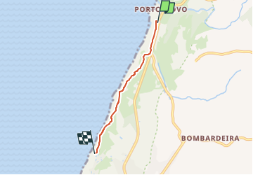
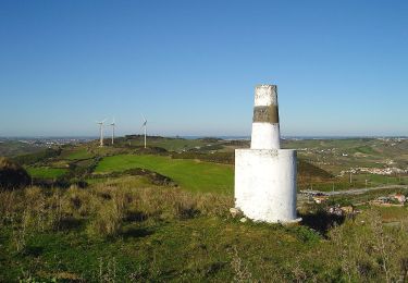
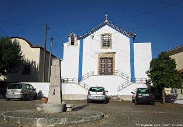
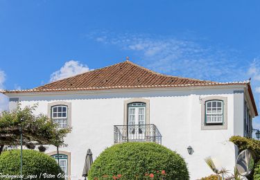
Trail On foot of 3.4 km to be discovered at Centro, Lisbon, A dos Cunhados e Maceira. This trail is proposed by SityTrail - itinéraires balisés pédestres.
Description
Trail created by Município de Torres Vedras.
Website: http://www.cm-tvedras.pt/atividade-fisica/percursos-pedestres/pr2-tvd/
Positioning
Country:
Portugal
Region :
Centro
Department/Province :
Lisbon
Municipality :
A dos Cunhados e Maceira
Location:
Maceira
Start:(Dec)
Start:(UTM)
469249 ; 4336221 (29S) N.
Comments
Trails nearby
![Trail On foot A dos Cunhados e Maceira - Pelos Caminhos da Batalha do Vimeiro - Photo](https://media.geolcdn.com/t/375/260/ext.jpg?maxdim=2&url=https%3A%2F%2Fmedia.geolcdn.com%2Ff%2F152a277d-7cdc-4c59-9d15-852398903aee.jpeg)
![On foot On foot](https://static1.geolcdn.com/sitytour/trail-icons/100.png)
Pelos Caminhos da Batalha do Vimeiro
On foot
Easy
A dos Cunhados e Maceira,
Centro,
Lisbon,
Portugal
![](/images/other/stat-length.png)
4.4 km | 5.4 km-effort
1h 13min
![](https://static1.geolcdn.com/siteimages/upload/files/16400158638029165_repeat_loop_refresh_sync_direction_icon.png)
No
![Trail On foot Lourinhã e Atalaia - Rota dos Dinossauros - Photo](https://media.geolcdn.com/t/375/260/ext.jpg?maxdim=2&url=https%3A%2F%2Fmedia.geolcdn.com%2Ff%2Fe4cdd5d0-9d97-4c20-8517-75e1b0e53b1a.jpeg)
![On foot On foot](https://static1.geolcdn.com/sitytour/trail-icons/100.png)
Rota dos Dinossauros
On foot
Easy
Lourinhã e Atalaia,
Centro,
Lisbon,
Portugal
![](/images/other/stat-length.png)
3 km | 4.1 km-effort
56min
![](https://static1.geolcdn.com/siteimages/upload/files/16400158638029165_repeat_loop_refresh_sync_direction_icon.png)
No
![Trail On foot Roliça - O Caminho da Roliça - Photo](https://media.geolcdn.com/t/375/260/ext.jpg?maxdim=2&url=https%3A%2F%2Fmedia.geolcdn.com%2Ff%2F9ffe6a88-ae89-435f-83c0-fb49a706944e.jpeg)
![On foot On foot](https://static1.geolcdn.com/sitytour/trail-icons/100.png)
O Caminho da Roliça
On foot
Easy
Roliça,
Centro,
Leiria,
Portugal
![](/images/other/stat-length.png)
5.7 km | 7.9 km-effort
1h 47min
![](https://static1.geolcdn.com/siteimages/upload/files/16400158638029165_repeat_loop_refresh_sync_direction_icon.png)
No
![Trail On foot Turcifal - Rota dos Encantos - Photo](https://media.geolcdn.com/t/375/260/ext.jpg?maxdim=2&url=https%3A%2F%2Fmedia.geolcdn.com%2Ff%2Fa5943450-f8cd-4c89-ac5d-d341e93a1473.jpeg)
![On foot On foot](https://static1.geolcdn.com/sitytour/trail-icons/100.png)
Rota dos Encantos
On foot
Difficult
Turcifal,
Centro,
Lisbon,
Portugal
![](/images/other/stat-length.png)
23 km | 32 km-effort
7h 16min
![](https://static1.geolcdn.com/siteimages/upload/files/16400158638029165_repeat_loop_refresh_sync_direction_icon.png)
Yes
![Trail On foot Dois Portos e Runa - Rota da Vinha e do Vinho - Photo](https://media.geolcdn.com/t/375/260/ext.jpg?maxdim=2&url=https%3A%2F%2Fmedia.geolcdn.com%2Ff%2F9988f08b-c8ba-47ca-9b96-728c199d91f7.jpeg)
![On foot On foot](https://static1.geolcdn.com/sitytour/trail-icons/100.png)
Rota da Vinha e do Vinho
On foot
Medium
Dois Portos e Runa,
Centro,
Lisbon,
Portugal
![](/images/other/stat-length.png)
15 km | 21 km-effort
4h 39min
![](https://static1.geolcdn.com/siteimages/upload/files/16400158638029165_repeat_loop_refresh_sync_direction_icon.png)
Yes
![Trail On foot Maxial e Monte Redondo - Rota das Lapas - Photo](https://media.geolcdn.com/t/375/260/ext.jpg?maxdim=2&url=https%3A%2F%2Fmedia.geolcdn.com%2Ff%2F0f74451f-f338-41a2-87ea-607f685e0dba.jpeg)
![On foot On foot](https://static1.geolcdn.com/sitytour/trail-icons/100.png)
Rota das Lapas
On foot
Easy
Maxial e Monte Redondo,
Centro,
Lisbon,
Portugal
![](/images/other/stat-length.png)
4.3 km | 5.8 km-effort
1h 18min
![](https://static1.geolcdn.com/siteimages/upload/files/16400158638029165_repeat_loop_refresh_sync_direction_icon.png)
No
![Trail On foot Santa Maria, São Pedro e Matacães - Rota do Castro do Zambujal - Photo](https://media.geolcdn.com/t/375/260/ext.jpg?maxdim=2&url=https%3A%2F%2Fmedia.geolcdn.com%2Ff%2Fb6196e00-b6e7-4ff7-a6d0-23b1a8a543a8.jpeg)
![On foot On foot](https://static1.geolcdn.com/sitytour/trail-icons/100.png)
Rota do Castro do Zambujal
On foot
Easy
Santa Maria, São Pedro e Matacães,
Centro,
Lisbon,
Portugal
![](/images/other/stat-length.png)
4.2 km | 5.3 km-effort
1h 11min
![](https://static1.geolcdn.com/siteimages/upload/files/16400158638029165_repeat_loop_refresh_sync_direction_icon.png)
No
![Trail On foot Freiria - Rota do Vento - Photo](https://media.geolcdn.com/t/375/260/ext.jpg?maxdim=2&url=https%3A%2F%2Fmedia.geolcdn.com%2Ff%2F8cf2d5be-142f-4564-9612-87bc1edddc2d.jpeg)
![On foot On foot](https://static1.geolcdn.com/sitytour/trail-icons/100.png)
![Trail On foot Carvoeira e Carmões - Rota das Quintas - Photo](https://media.geolcdn.com/t/375/260/ext.jpg?maxdim=2&url=https%3A%2F%2Fmedia.geolcdn.com%2Ff%2F06230ace-96f5-4094-a508-c85ca288b61f.jpeg)
![On foot On foot](https://static1.geolcdn.com/sitytour/trail-icons/100.png)
Rota das Quintas
On foot
Medium
Carvoeira e Carmões,
Centro,
Lisbon,
Portugal
![](/images/other/stat-length.png)
15 km | 21 km-effort
4h 51min
![](https://static1.geolcdn.com/siteimages/upload/files/16400158638029165_repeat_loop_refresh_sync_direction_icon.png)
Yes